Restaurant nearby Tűzhely étterem
Hungary
Restaurant nearby Tűzhely étterem
Tűzhely étterem
143/A, Balatoni út, 1112, Budapest, HU Hungary
contacts phone
:
+36 20 491 1411
Latitude:
47.447087
, Longitude:
19.0060458
larger map & directions
read more
nearest Restaurant
101 m
Tűzhely Café & Restaurant
Budapest, Kőérberek
Restaurant
read more
506 m
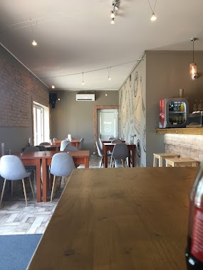
Solli Étterem
Budapest, Tippan utca 2
Restaurant
read more
528 m
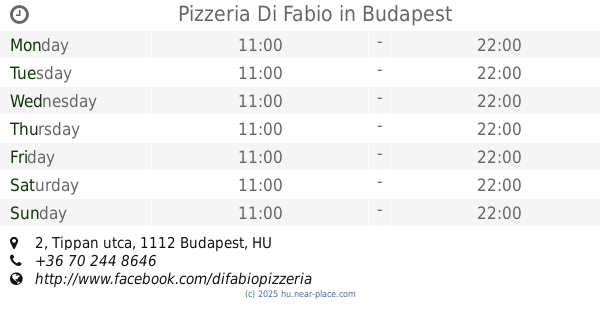
Pizzeria Di Fabio
Budapest, Tippan utca 2
Restaurant
read more
712 m
Kosi Falodája
Budapest, Vöröskúti határsor 35
Restaurant
read more
1.315 km
Sz.I. Kft
1116 Budapest, Ringló út 70
Restaurant
read more
1.451 km
Retisas Vendeglo
Budapest, Hunyadi Mátyás út 56
Restaurant
read more
1.459 km
Málnás Bisztró
Budapest, Hunyadi Mátyás út 56
Restaurant
read more
1.475 km
Pikoló Söröző-Étterem
Budapest, Igmándi utca 30
Restaurant
read more
1.578 km
Tutti Pizza
Budapest, Repülőtéri út 6.
Restaurant
read more
1.796 km
Don Pepe Menyecske
Budapest, Menyecske utca 15
Restaurant
read more
1.825 km
Mag Kert
Budapest, Kelenvölgyi határsor 3
Restaurant
read more
1.831 km
M4 Bisztró
Budapest, Andor utca 47-49
Restaurant
read more
1.834 km
Íz-é Faloda Roadhouse
Budapest, Neszmélyi köz 3
Restaurant
read more
2.07 km
McDonald's
Budapest, Budaörsi út 112
Restaurant
read more
2.142 km
Roxane Étterem
Budapest, Csorbai utca 3/c
Restaurant
read more
2.233 km
Majorvendéglő
Budapest, major utca 57
Restaurant
read more
2.233 km
Major Vendéglő
Budapest, major utca 57
Restaurant
read more
2.263 km
Park Büfé
Budapest, Etele tér 11a
Restaurant
read more
2.308 km
Resti Söröző
Budapest, Etele tér 6
Restaurant
read more
2.607 km
Főnökasszony Maga Főz
Budapest, Etele út 59-61
Restaurant
read more
2.658 km
Chil2Bistro
Budapest, Etele út 57
Restaurant
read more
2.718 km
Burger King
Budapest, Etele út 53
Restaurant
read more
2.723 km
Hugi Büfé
Budapest, Vahot utca 8
Restaurant
read more
2.732 km
Retro BÜFÉ
Budapest, Etele út 53
Restaurant
read more
2.765 km
Kézzel_húzott házi rétes
Budapest, Etele út 63
Restaurant
read more
📑
all categories
Accounting
Administrative area level 1
Administrative area level 2
Airport
Amusement park
Aquarium
Art gallery
Atm
Bakery
Bank
Bar
Beauty salon
Bicycle store
Book store
Bowling alley
Bus station
Cafe
Campground
Car dealer
Car rental
Car repair
Car wash
Casino
Cemetery
Church
City hall
Clothing store
Colloquial area
Convenience store
Country
Courthouse
Dentist
Department store
Doctor
Electrician
Electronics store
Embassy
Finance
Fire station
Florist
Food
Funeral home
Furniture store
Gas station
General contractor
Grocery or supermarket
Gym
Hair care
Hardware store
Health
Hindu Temple
Home goods store
Hospital
Insurance agency
Intersection
Jewelry store
Laundry
Lawyer
Library
Light rail station
Liquor store
Local government office
Locality
Locksmith
Lodging
Meal delivery
Meal takeaway
Mosque
Movie rental
Movie theater
Moving company
Museum
Natural feature
Neighborhood
Night club
Painter
Park
Parking
Pet store
Pharmacy
Physiotherapist
Place of worship
Plumber
Point of interest
Police
Political
Post office
Premise
Real estate agency
Restaurant
Roofing contractor
Route
Rv park, camping
School
Shoe store
Shopping mall
Spa
Stadium
Storage
Store
Subpremise
Subway station
Supermarket
Synagogue
Taxi stand
Train station
Transit station
Travel agency
University
Veterinary care
Zoo
administrative area level 3
sublocality level 1
↑