Restaurant nearby Maláta Söröző
Hungary
Restaurant nearby Maláta Söröző
Maláta Söröző
Tardos, Temető utca 3 Magyarország
contacts phone
:
+36
Latitude:
47.6627446
, Longitude:
18.4475416
read more
nearest Restaurant
61 m
Kemencés Fogadó
Tardos, Templom tér 14
Restaurant
read more
80 m
Retro Pizza & Café
Tardos, 15, Templom tér
Restaurant
read more
991 m
Malomvölgy Büfé
Tardos
Restaurant
read more
7.588 km
Vén Prés
Tarján, Szőlőhegy utca 39
Restaurant
read more
8.182 km
Szálka Bár
Tata
Restaurant
read more
8.457 km
Pikant Restaurant
Tata, Építők parkja 1
Restaurant
read more
8.521 km
Haluci
Tata, Tópart sétány 15
Restaurant
read more
8.696 km
Hilltop-Bor Kft. - Hilltop Borhotel és Étterem
2544 Neszmély, Melegeshegy
Restaurant
read more
9.021 km
Pizza & Gyros Bár
Tata, Ady Endre utca 55
Restaurant
read more
9.386 km
KFC Tata
Tata, M1 autópálya, Remeteségi pihenőhely, Tata mellett
Restaurant
read more
9.408 km
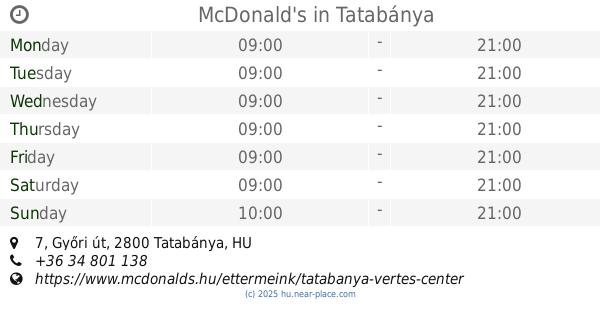
McDonald's
Tatabánya, 9, Győri út 7
Restaurant
read more
9.508 km
Istanbul Kebab Tatabánya
Tatabánya, Fő tér 16/b
Restaurant
read more
9.827 km
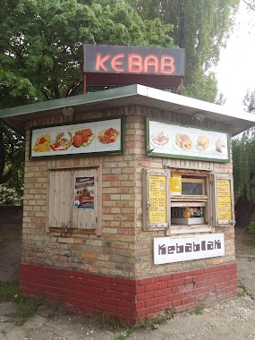
Kebablak
Tata, Váralja utca 4
Restaurant
read more
9.861 km
Bacon Burger
Tata, 4, Piac tér
Restaurant
read more
9.926 km
IL VILLAGGIO
Csabdi, Szabadsgá utc 67
Restaurant
read more
9.977 km
Gyros Pont
Tatabánya, Vadász utca 48
Restaurant
read more
10.192 km
Turul Kisvendéglő
Tatabánya, Bánhidai lakótelep 117
Restaurant
read more
10.541 km
Jankó Vendéglő
Süttő, Dunamocsi 1
Restaurant
read more
10.918 km
Paradicsom Vendéglő
Tatabánya, Dankó Pista utca 1
Restaurant
read more
12.101 km
Árkád Étkezde semmire nem való
Tatabánya, Ságvári Endre út 3
Restaurant
read more
12.305 km
Granárium Központ / Pánczél Szolgáltató Kft.
Nagysáp, Granárium domb 3
Restaurant
read more
13.407 km
Espi Söröző
Nyergesújfalu, Felszabadulás tér 60
Restaurant
read more
14.732 km
Hafner Vendéglő
Tatabánya
Restaurant
read more
15.356 km
Pizza Like
Környe, Alkotmány utca 41
Restaurant
read more
16.865 km
Öreghalász Hotel
Tát, Fő út 2
Restaurant
read more
📑
all categories
Accounting
Administrative area level 1
Administrative area level 2
Airport
Amusement park
Aquarium
Art gallery
Atm
Bakery
Bank
Bar
Beauty salon
Bicycle store
Book store
Bowling alley
Bus station
Cafe
Campground
Car dealer
Car rental
Car repair
Car wash
Casino
Cemetery
Church
City hall
Clothing store
Colloquial area
Convenience store
Country
Courthouse
Dentist
Department store
Doctor
Electrician
Electronics store
Embassy
Finance
Fire station
Florist
Food
Funeral home
Furniture store
Gas station
General contractor
Grocery or supermarket
Gym
Hair care
Hardware store
Health
Hindu Temple
Home goods store
Hospital
Insurance agency
Intersection
Jewelry store
Laundry
Lawyer
Library
Light rail station
Liquor store
Local government office
Locality
Locksmith
Lodging
Meal delivery
Meal takeaway
Mosque
Movie rental
Movie theater
Moving company
Museum
Natural feature
Neighborhood
Night club
Painter
Park
Parking
Pet store
Pharmacy
Physiotherapist
Place of worship
Plumber
Point of interest
Police
Political
Post office
Premise
Real estate agency
Restaurant
Roofing contractor
Route
Rv park, camping
School
Shoe store
Shopping mall
Spa
Stadium
Storage
Store
Subpremise
Subway station
Supermarket
Synagogue
Taxi stand
Train station
Transit station
Travel agency
University
Veterinary care
Zoo
administrative area level 3
sublocality level 1
↑