Pharmacy nearby Erdők-Mezők Patikája
Hungary
Pharmacy nearby Erdők-Mezők Patikája
Erdők-Mezők Patikája
Mohács, Szabadság utca 26 Magyarország
contacts phone
:
+36
Latitude:
45.9909668
, Longitude:
18.6887326
read more
nearest Pharmacy
291 m
Kernya István Dr. Magángyógyszertár
Mohács, Szentháromság utca 2
Pharmacy
read more
389 m
Tulipán Gyógyszertár
Mohács, Dózsa György utca 16
Pharmacy
read more
394 m
Tulipán Gyógyszertár
Mohács, Dózsa György utca 18
Pharmacy
read more
423 m
Szentháromság patika
Mohács, Szabadság utca 1
Pharmacy
read more
678 m
II. Lajos Király Gyógyszertár
7700 Mohács, Dózsa Gy. utca 44 .
Pharmacy
read more
1.012 km
Szent Ferenc Patika
Mohács, Kossuth Lajos út 66
Pharmacy
read more
2.335 km
PatikaPlus
Mohács, Pécsi út 61
Pharmacy
read more
4.697 km
Forrás Gyógyszertár
Lánycsók, Béke tér 29
Pharmacy
read more
10.329 km
Forrás Gyógyszertár
Somberek, Kossuth Lajos utca 109
Pharmacy
read more
10.926 km
Gyógyszertár
Babarc, Béke utca 35
Pharmacy
read more
11.846 km
Gyógyszertár
Dunaszekcső, Rév utca 1
Pharmacy
read more
12.002 km
Gyöngy Patika
Dunaszekcső, Rév utca 1
Pharmacy
read more
13.481 km
Panacea Gyógyszertár
Bóly, Ady Endre utca 8
Pharmacy
read more
13.567 km
Gyógyszertár
Himesháza, Hősök tere 8
Pharmacy
read more
16.908 km
Szent László Pharmacy
Báta, Fő utca 202
Pharmacy
read more
16.908 km
Szent László Patika
Báta, Fő utca 202
Pharmacy
read more
17.308 km
Szent Imre Gyógyszertár Bt.
Nagybaracska, Tulbanov utca 4
Pharmacy
read more
17.389 km
Medicinále Patika
Dávod, József Attila utca 36
Pharmacy
read more
22.254 km
Altus Gyógyszertár
Bátaszék, Budai utca 17
Pharmacy
read more
27.998 km
Szentháromság Patika
Pécsvárad, Szentháromság tér 7
Pharmacy
read more
28.262 km
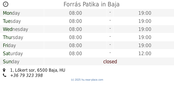
Forrás Patika
Baja, Lőkert sor 1
Pharmacy
read more
28.786 km
Pharmaurum Kfc.
Baja, Szabadság út 28
Pharmacy
read more
29.63 km
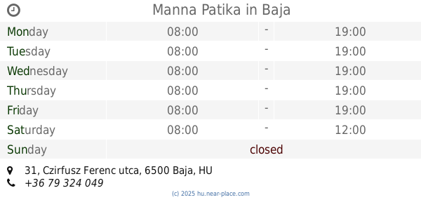
Manna Patika
Baja, Czirfusz Ferenc utca 31
Pharmacy
read more
30.768 km
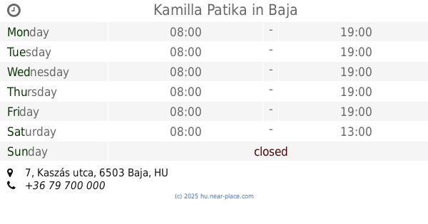
Kamilla Patika
Baja, Kaszás utca 7
Pharmacy
read more
31.726 km
Szent István Patika BT.
Baja, Dózsa György út 197
Pharmacy
read more
📑
all categories
Accounting
Administrative area level 1
Administrative area level 2
Airport
Amusement park
Aquarium
Art gallery
Atm
Bakery
Bank
Bar
Beauty salon
Bicycle store
Book store
Bowling alley
Bus station
Cafe
Campground
Car dealer
Car rental
Car repair
Car wash
Casino
Cemetery
Church
City hall
Clothing store
Colloquial area
Convenience store
Country
Courthouse
Dentist
Department store
Doctor
Electrician
Electronics store
Embassy
Finance
Fire station
Florist
Food
Funeral home
Furniture store
Gas station
General contractor
Grocery or supermarket
Gym
Hair care
Hardware store
Health
Hindu Temple
Home goods store
Hospital
Insurance agency
Intersection
Jewelry store
Laundry
Lawyer
Library
Light rail station
Liquor store
Local government office
Locality
Locksmith
Lodging
Meal delivery
Meal takeaway
Mosque
Movie rental
Movie theater
Moving company
Museum
Natural feature
Neighborhood
Night club
Painter
Park
Parking
Pet store
Pharmacy
Physiotherapist
Place of worship
Plumber
Point of interest
Police
Political
Post office
Premise
Real estate agency
Restaurant
Roofing contractor
Route
Rv park, camping
School
Shoe store
Shopping mall
Spa
Stadium
Storage
Store
Subpremise
Subway station
Supermarket
Synagogue
Taxi stand
Train station
Transit station
Travel agency
University
Veterinary care
Zoo
administrative area level 3
sublocality level 1
↑