Pharmacy nearby Pharmaurum Kfc.
Hungary
Pharmacy nearby Pharmaurum Kfc.
Pharmaurum Kfc.
28, Szabadság út, 6500, Baja, HU Hungary
contacts phone
:
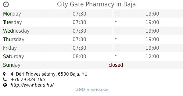
+36 79 321 627
Latitude:
46.1741016
, Longitude:
18.9525942
larger map & directions
read more
nearest Pharmacy
1 m
Aranykereszt Gyógyszertár
Baja, Szabadság út 28
Pharmacy
read more
616 m
City Gate Pharmacy
Baja, Déri Frigyes sétány 4
Pharmacy
read more
616 m
Városkapu Gyógyszertár
Baja, Déri Frigyes sétány 4
Pharmacy
read more
672 m
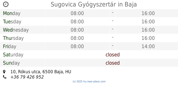
Sugovica Gyógyszertár
Baja, Rókus utca 10
Pharmacy
read more
722 m
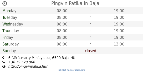
Pingvin Patika
Baja, Vörösmarty Mihály utca 6
Pharmacy
read more
797 m
Kígyó Gyógyszertár
Baja, Vörösmarty Mihály utca 14
Pharmacy
read more
875 m
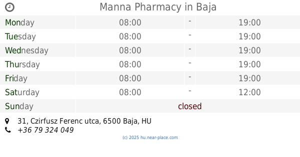
Manna Patika
Baja, Czirfusz Ferenc utca 31
Pharmacy
read more
875 m
Manna Pharmacy
Baja, Czirfusz Ferenc utca 31
Pharmacy
read more
971 m
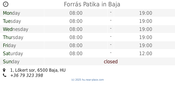
Forrás Patika
Baja, Lőkert sor 1
Pharmacy
read more
1.407 km
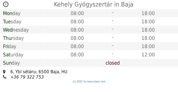
Kehely Gyógyszertár
Baja, Ybl sétány 6
Pharmacy
read more
2.398 km
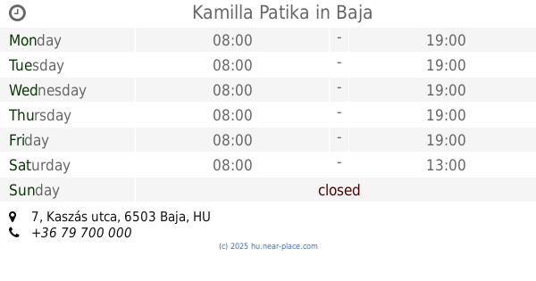
Kamilla Patika
Baja, Kaszás utca 7
Pharmacy
read more
3.522 km
Szent István Pharmacy
Baja, Dózsa György út 197
Pharmacy
read more
3.522 km
Szent István Patika BT.
Baja, Dózsa György út 197
Pharmacy
read more
8.099 km
Máriakönnye Fiókpatika
Bátmonostor, Zrínyi Miklós utca 7
Pharmacy
read more
9.041 km
Csanád-Patika
Érsekcsanád, Dózsa György út 78
Pharmacy
read more
14.284 km
Szent László Pharmacy
Báta, Fő utca 202
Pharmacy
read more
14.284 km
Szent László Patika
Báta, Fő utca 202
Pharmacy
read more
15.383 km
Szent Imre Gyógyszertár Bt.
Nagybaracska, Tulbanov utca 4
Pharmacy
read more
16.671 km
Majoranna Patika Kft.
Rém, Május 1. utca 19
Pharmacy
read more
17.767 km
Gyöngy Patika
Dunaszekcső, Rév utca 1
Pharmacy
read more
17.833 km
Gyógyszertár
Dunaszekcső, Rév utca 1
Pharmacy
read more
18.213 km
Védangyal Gyógyszertár
Bácsborsód, Rákóczi Ferenc utca 1
Pharmacy
read more
19.16 km
crown Pharmacy
Decs, Őcsényi utca 10/a
Pharmacy
read more
19.16 km
Korona Patika
Decs, Őcsényi utca 10/a
Pharmacy
read more
19.16 km
Korona Gyógyszertár
Decs, Őcsényi utca 10/a
Pharmacy
read more
📑
all categories
Accounting
Administrative area level 1
Administrative area level 2
Airport
Amusement park
Aquarium
Art gallery
Atm
Bakery
Bank
Bar
Beauty salon
Bicycle store
Book store
Bowling alley
Bus station
Cafe
Campground
Car dealer
Car rental
Car repair
Car wash
Casino
Cemetery
Church
City hall
Clothing store
Colloquial area
Convenience store
Country
Courthouse
Dentist
Department store
Doctor
Electrician
Electronics store
Embassy
Finance
Fire station
Florist
Food
Funeral home
Furniture store
Gas station
General contractor
Grocery or supermarket
Gym
Hair care
Hardware store
Health
Hindu Temple
Home goods store
Hospital
Insurance agency
Intersection
Jewelry store
Laundry
Lawyer
Library
Light rail station
Liquor store
Local government office
Locality
Locksmith
Lodging
Meal delivery
Meal takeaway
Mosque
Movie rental
Movie theater
Moving company
Museum
Natural feature
Neighborhood
Night club
Painter
Park
Parking
Pet store
Pharmacy
Physiotherapist
Place of worship
Plumber
Point of interest
Police
Political
Post office
Premise
Real estate agency
Restaurant
Roofing contractor
Route
Rv park, camping
School
Shoe store
Shopping mall
Spa
Stadium
Storage
Store
Subpremise
Subway station
Supermarket
Synagogue
Taxi stand
Train station
Transit station
Travel agency
University
Veterinary care
Zoo
administrative area level 3
sublocality level 1
↑