Park nearby Városkút
Hungary
Park nearby Városkút
Városkút
Devecseri Gábor park, 1125, Budapest, HU Magyarország
contacts phone
:
+36
Latitude:
47.5012796
, Longitude:
18.9878912
larger map & directions
read more
nearest Park
441 m
Eötvös József park
Budapest, Diana utca 1
Park
read more
748 m
Széchenyi emlékmű
Budapest, Széchenyi-emlék út 12
Park
read more
748 m
Széchenyi Monument
Budapest, Széchenyi-emlék út 12
Park
read more
1.713 km
Kiserdő
Budapest, Dániel út 66
Park
read more
1.756 km
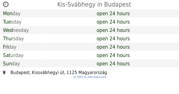
Kis-Svábhegy
Budapest, Kissvábhegyi út
Park
read more
1.763 km
Botanicon Kert Klub
Budapest, Kázmér út 51.
Park
read more
1.792 km
Szent Család park
XII. kerület
Park
read more
1.926 km
Torockó tér
II. kerület
Park
read more
1.93 km
Pasaréti Gyermekpark
Budapest, Torockó tér 1
Park
read more
2.038 km
Parque de Normafa
Budapest, 105039,, Jánoshegyi út
Park
read more
2.225 km
Városmajori kutyafuttató
Budapest, Temes utca
Park
read more
2.259 km
Rockerek.hu Találkozók Helyszíne
Budapest
Park
read more
2.322 km
Minden Szentek tere
Budapest, Németvölgyi út
Park
read more
2.374 km
Normafa Kutyaiskola és Életmód Központ
Budapest, Konkoly-Thege Miklós út 27
Park
read more
2.534 km
Varosmajori Elso Kutyafuttato
Budapest, Városmajor utca
Park
read more
2.713 km
Kiskertek.com
Budapest, Táska utca 5
Park
read more
3.08 km
Millenáris
Budapest, Kis Rókus utca
Park
read more
3.112 km
Bibó parki kutyafuttató
Budapest, Bimbó út 35
Park
read more
3.135 km
Brasov Komondor park and nature trail
Budapest, Brassó út 80a
Park
read more
3.207 km
Budai Sas-hegy Természetvédelmi terület
Budapest
Park
read more
3.534 km
Vérhalom téri park és játszótér
Budapest, Vérhalom tér
Park
read more
3.605 km
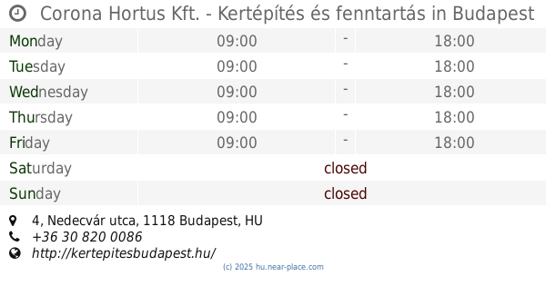
Corona Hortus Kft. - Kertépítés és fenntartás
Budapest, Nedecvár utca 4
Park
read more
3.727 km
Pilisi Parkerdő Zrt.
Budapest, Budakeszi út 91
Park
read more
3.843 km
József-hegyi-barlang
Budapest, Józsefhegyi utca 19a
Park
read more
3.981 km
Piktortégla park
Budaörs
Park
read more
📑
all categories
Accounting
Administrative area level 1
Administrative area level 2
Airport
Amusement park
Aquarium
Art gallery
Atm
Bakery
Bank
Bar
Beauty salon
Bicycle store
Book store
Bowling alley
Bus station
Cafe
Campground
Car dealer
Car rental
Car repair
Car wash
Casino
Cemetery
Church
City hall
Clothing store
Colloquial area
Convenience store
Country
Courthouse
Dentist
Department store
Doctor
Electrician
Electronics store
Embassy
Finance
Fire station
Florist
Food
Funeral home
Furniture store
Gas station
General contractor
Grocery or supermarket
Gym
Hair care
Hardware store
Health
Hindu Temple
Home goods store
Hospital
Insurance agency
Intersection
Jewelry store
Laundry
Lawyer
Library
Light rail station
Liquor store
Local government office
Locality
Locksmith
Lodging
Meal delivery
Meal takeaway
Mosque
Movie rental
Movie theater
Moving company
Museum
Natural feature
Neighborhood
Night club
Painter
Park
Parking
Pet store
Pharmacy
Physiotherapist
Place of worship
Plumber
Point of interest
Police
Political
Post office
Premise
Real estate agency
Restaurant
Roofing contractor
Route
Rv park, camping
School
Shoe store
Shopping mall
Spa
Stadium
Storage
Store
Subpremise
Subway station
Supermarket
Synagogue
Taxi stand
Train station
Transit station
Travel agency
University
Veterinary care
Zoo
administrative area level 3
sublocality level 1
↑