Park nearby Tulipán tér
Hungary
Park nearby Tulipán tér
Tulipán tér
Dunaharaszti, 2330 Węgry
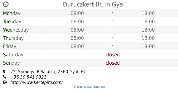
contacts phone
:
+36
Latitude:
47.3529079
, Longitude:
19.104137
larger map & directions
read more
nearest Park
919 m
Kecskeméti Arborétum
Dunaharaszti, Kandó Kálmán utca 25
Park
read more
953 m
Baktay Ervin szobra
Dunaharaszti, Baktay Ervin tér 5
Park
read more
1.095 km
Hősök tere
Dunaharaszti
Park
read more
1.349 km
Memorial Park Funeral
Dunaharaszti, Baktay Ervin utca 13
Park
read more
1.349 km
Kegyeleti emlékpark
Dunaharaszti, Baktay Ervin utca 13
Park
read more
4.446 km
Szigetszentmiklós Úszóláp
Szigetszentmiklós, Tanösvény
Park
read more
4.676 km
Tagi Bányató
Szigetszentmiklós, Unnamed Road
Park
read more
4.753 km
Kavicsos-tó
Szigetszentmiklós, IX. part 8
Park
read more
4.819 km
Kéktó Szabadidőközpont
Szigetszentmiklós, Diófa utca
Park
read more
4.894 km
Nemzeti Összetartozás parkja
Szigetszentmiklós
Park
read more
5.066 km
Illyés Gyula park
Szigetszentmiklós
Park
read more
5.393 km
Nagygödör
Alsónémedi
Park
read more
6.579 km
Halászy Károly utcai sporttelep
Alsónémedi
Park
read more
8.293 km
Magyarok Nagyasszonya tér
Budapest
Park
read more
9.213 km
Duruczkert Bt.
Gyál, Somogyi Béla utca 22
Park
read more
11.035 km
Cankó tér
XXII. kerület
Park
read more
11.88 km
vörös réteg
Érd
Park
read more
12.862 km
Kutyafuttató - Pöttyös
Budapest, Üllői út 173
Park
read more
13.959 km
Nyugdíjasok Kertje
Budapest, Fraknó utca 22
Park
read more
14.218 km
Levendulás Park
Budapest, Kanizsai utca 28
Park
read more
14.26 km
Feeling Rain pavilonshop
Budapest, 1104 Lavotta u 6
Park
read more
14.392 km
Orczy Garden
Budapest, Orczy út 1
Park
read more
14.476 km
KRESZ park
Budapest, Kőér utca 27
Park
read more
15.535 km
Brasov Komondor park and nature trail
Budapest, Brassó út 80a
Park
read more
16.94 km
Szantofold
13567/553, 1523 Helyrajzi szám utca
Park
read more
📑
all categories
Accounting
Administrative area level 1
Administrative area level 2
Airport
Amusement park
Aquarium
Art gallery
Atm
Bakery
Bank
Bar
Beauty salon
Bicycle store
Book store
Bowling alley
Bus station
Cafe
Campground
Car dealer
Car rental
Car repair
Car wash
Casino
Cemetery
Church
City hall
Clothing store
Colloquial area
Convenience store
Country
Courthouse
Dentist
Department store
Doctor
Electrician
Electronics store
Embassy
Finance
Fire station
Florist
Food
Funeral home
Furniture store
Gas station
General contractor
Grocery or supermarket
Gym
Hair care
Hardware store
Health
Hindu Temple
Home goods store
Hospital
Insurance agency
Intersection
Jewelry store
Laundry
Lawyer
Library
Light rail station
Liquor store
Local government office
Locality
Locksmith
Lodging
Meal delivery
Meal takeaway
Mosque
Movie rental
Movie theater
Moving company
Museum
Natural feature
Neighborhood
Night club
Painter
Park
Parking
Pet store
Pharmacy
Physiotherapist
Place of worship
Plumber
Point of interest
Police
Political
Post office
Premise
Real estate agency
Restaurant
Roofing contractor
Route
Rv park, camping
School
Shoe store
Shopping mall
Spa
Stadium
Storage
Store
Subpremise
Subway station
Supermarket
Synagogue
Taxi stand
Train station
Transit station
Travel agency
University
Veterinary care
Zoo
administrative area level 3
sublocality level 1
↑