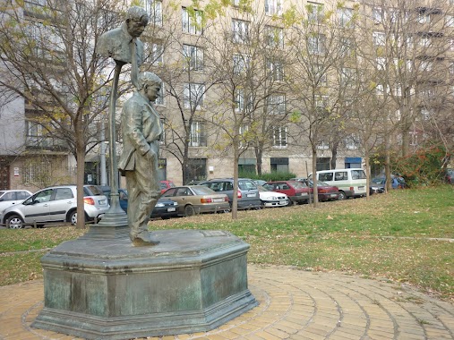
Park nearby Polgári áldozatok emlékműve
Hungary
Park nearby Polgári áldozatok emlékműve
Polgári áldozatok emlékműve
2-4, Máriássy utca, 1095, Budapest, HU Magyarország
contacts phone
:
+36
Latitude:
47.4689913
, Longitude:
19.0779412
larger map & directions
read more
nearest Park
499 m
Kertvilágítás Kft.
Budapest, Soroksári út 48
Park
read more
646 m
IX Kerület Kutyafuttatö
Budapest, Mester utca 67
Park
read more
666 m
Haller Park
Budapest, Mester utca 70
Park
read more
702 m
Bajor Gizi park
Budapest, Bajor Gizi park 1
Park
read more
1.196 km
Kerekerdő park
Budapest
Park
read more
1.202 km
Kerekerdő park
Budapest, Kerekerdő park
Park
read more
1.365 km
Fehér Marcell Emlékpark
XI. kerület
Park
read more
1.39 km
Ferenc tér
Budapest, Ferenc tér 1
Park
read more
1.497 km
Ludovika tér
Budapest
Park
read more
1.527 km
Salkaházi Sára park
IX. kerület
Park
read more
1.618 km
Orczy kert
Budapest, Orczy út 1
Park
read more
1.632 km
Orczy Garden
Budapest, Orczy út 1
Park
read more
1.654 km
Bogdánfy Parkoló Udvar
Budapest, Bogdánfy utca 10
Park
read more
1.729 km
Rezső tér
Budapest
Park
read more
1.729 km
Szenes Iván tér
Budapest
Park
read more
1.801 km
Bakáts Square
Budapeszt
Park
read more
1.821 km
Csillám Park
Budapest, Irinyi József utca 23
Park
read more
1.825 km
Füvészkert
Budapest, Illés utca 25
Park
read more
1.959 km
Csillám park
Budapest, Irinyi József utca 47
Park
read more
1.96 km
Telekom Park
Budapest, Prielle Kornélia utca 53
Park
read more
1.965 km
Park
Budapest, Molnár Ferenc tér
Park
read more
1.99 km
Aranyhíd játszótér
Budapest, Saru utca 11
Park
read more
2.032 km
Práter park
Budapest, Práter utca 58
Park
read more
2.132 km
Markusovszky tér
Budapeszt
Park
read more
2.136 km
Kutyafuttató - Markusovszky tér
Budapest, Markusovszky tér
Park
read more
📑
all categories
Accounting
Administrative area level 1
Administrative area level 2
Airport
Amusement park
Aquarium
Art gallery
Atm
Bakery
Bank
Bar
Beauty salon
Bicycle store
Book store
Bowling alley
Bus station
Cafe
Campground
Car dealer
Car rental
Car repair
Car wash
Casino
Cemetery
Church
City hall
Clothing store
Colloquial area
Convenience store
Country
Courthouse
Dentist
Department store
Doctor
Electrician
Electronics store
Embassy
Finance
Fire station
Florist
Food
Funeral home
Furniture store
Gas station
General contractor
Grocery or supermarket
Gym
Hair care
Hardware store
Health
Hindu Temple
Home goods store
Hospital
Insurance agency
Intersection
Jewelry store
Laundry
Lawyer
Library
Light rail station
Liquor store
Local government office
Locality
Locksmith
Lodging
Meal delivery
Meal takeaway
Mosque
Movie rental
Movie theater
Moving company
Museum
Natural feature
Neighborhood
Night club
Painter
Park
Parking
Pet store
Pharmacy
Physiotherapist
Place of worship
Plumber
Point of interest
Police
Political
Post office
Premise
Real estate agency
Restaurant
Roofing contractor
Route
Rv park, camping
School
Shoe store
Shopping mall
Spa
Stadium
Storage
Store
Subpremise
Subway station
Supermarket
Synagogue
Taxi stand
Train station
Transit station
Travel agency
University
Veterinary care
Zoo
administrative area level 3
sublocality level 1
↑