Park nearby Fehér Marcell Emlékpark
Hungary
Park nearby Fehér Marcell Emlékpark
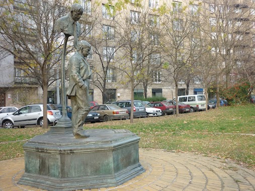
Fehér Marcell Emlékpark
Pázmány Péter sétány, 1117, Budapest, HU Magyarország
contacts phone
:
+36
Latitude:
47.4735283
, Longitude:
19.0610693
larger map & directions
read more
nearest Park
Fehér Marcell Emlékpark
Budapest, Fehér Marcell Emlékpark, Pázmány Péter sétány
Park
read more
313 m
Egyetemisták parkja
Budapest
Park
read more
324 m
Bogdánfy Parkoló Udvar
Budapest, Bogdánfy utca 10
Park
read more
461 m
Csillám Park
Budapest, Irinyi József utca 23
Park
read more
474 m
Goldmann György tér
Budapeszt
Park
read more
474 m
Goldmann György tér
Budapest
Park
read more
613 m
Csillám park
Budapest, Irinyi József utca 47
Park
read more
639 m
Aranyhíd játszótér
Budapest, Saru utca 11
Park
read more
684 m
Kopaszi gát
Budapest, Kelenföld
Park
read more
684 m
Kopaszi dike
Budapest, Kelenföld
Park
read more
688 m
Bajor Gizi park
Budapest, Bajor Gizi park 1
Park
read more
906 m
Kertvilágítás Kft.
Budapest, Soroksári út 48
Park
read more
912 m
Nehru coast
Budapest, Nehru part
Park
read more
945 m
Andergarden
Budapest, Erőmű utca 5
Park
read more
951 m
Majer Imre Park
Lágymányos
Park
read more
967 m
Tinódi park
Budapest, Tinódi utca 14
Park
read more
967 m
Telekom Park
Budapest, Prielle Kornélia utca 53
Park
read more
984 m
Gárdonyi tér
Budapest
Park
read more
984 m
Gárdonyi tér
Budapeszt
Park
read more
1.043 km
The Starting Point of 1956 Revolution
Budapest, Budafoki út 4
Park
read more
1.043 km
forradalom 1956 kiindulópontja
Budapest, Budafoki út 4
Park
read more
1.111 km
Open Air Design Tervező és Tanácsadó Kft.
Budapest, Móricz ZSigmond körtér 1. 1. emelet
Park
read more
1.257 km
Ferenc tér
Budapest, Ferenc tér 1
Park
read more
1.607 km
Levendulás Park
Budapest, Kanizsai utca 28
Park
read more
2.538 km
Kálvária tér
Budapest
Park
read more
📑
all categories
Accounting
Administrative area level 1
Administrative area level 2
Airport
Amusement park
Aquarium
Art gallery
Atm
Bakery
Bank
Bar
Beauty salon
Bicycle store
Book store
Bowling alley
Bus station
Cafe
Campground
Car dealer
Car rental
Car repair
Car wash
Casino
Cemetery
Church
City hall
Clothing store
Colloquial area
Convenience store
Country
Courthouse
Dentist
Department store
Doctor
Electrician
Electronics store
Embassy
Finance
Fire station
Florist
Food
Funeral home
Furniture store
Gas station
General contractor
Grocery or supermarket
Gym
Hair care
Hardware store
Health
Hindu Temple
Home goods store
Hospital
Insurance agency
Intersection
Jewelry store
Laundry
Lawyer
Library
Light rail station
Liquor store
Local government office
Locality
Locksmith
Lodging
Meal delivery
Meal takeaway
Mosque
Movie rental
Movie theater
Moving company
Museum
Natural feature
Neighborhood
Night club
Painter
Park
Parking
Pet store
Pharmacy
Physiotherapist
Place of worship
Plumber
Point of interest
Police
Political
Post office
Premise
Real estate agency
Restaurant
Roofing contractor
Route
Rv park, camping
School
Shoe store
Shopping mall
Spa
Stadium
Storage
Store
Subpremise
Subway station
Supermarket
Synagogue
Taxi stand
Train station
Transit station
Travel agency
University
Veterinary care
Zoo
administrative area level 3
sublocality level 1
↑