Park nearby Gesztenyés-kert
Hungary
Park nearby Gesztenyés-kert
Gesztenyés-kert
Budapest, Jagelló út, 1124 Ungarn
contacts phone
:
+36
website:
budaigesztenyes.hu
Latitude:
47.4894512
, Longitude:
19.0205928
larger map & directions
read more
nearest Park
57 m
Gróf Esterházy János emlékmű
Budapest, Jagelló út
Park
read more
444 m
Apor Vilmos Park
Németvölgy
Park
read more
515 m
Fejér Kert
Budapest, Breznó köz 11
Park
read more
880 m
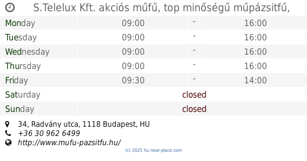
S.Telelux Kft. akciós műfű, top minőségű műpázsitfű, FIFA licences sport műfű
Budapest, Radvány utca 34
Park
read more
961 m
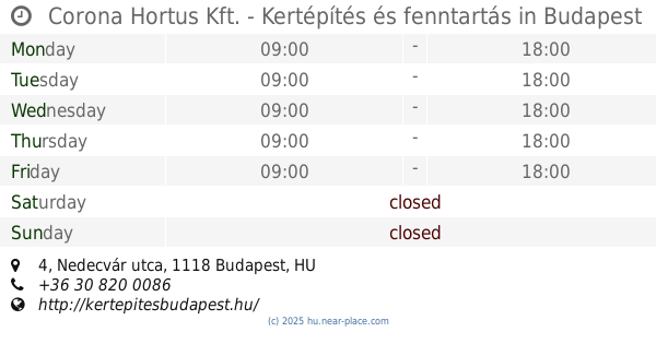
Corona Hortus Kft. - Kertépítés és fenntartás
Budapest, Nedecvár utca 4
Park
read more
999 m
Naphegy tér
Budapest, Tigris utca 51
Park
read more
1.064 km
Budai Sas-hegy Természetvédelmi terület
Budapest
Park
read more
1.218 km
Park
Krisztinaváros
Park
read more
1.248 km
Minden Szentek tere
Budapest, Németvölgyi út
Park
read more
1.36 km
Logodi utcai Park
Krisztinaváros
Park
read more
1.526 km
Tóth Árpád Promenade
Budapest, Tóth Árpád sétány
Park
read more
1.596 km
Magyar Jakobinusok kivégzésének emlékére
Budapest, Vérmező park
Park
read more
1.645 km
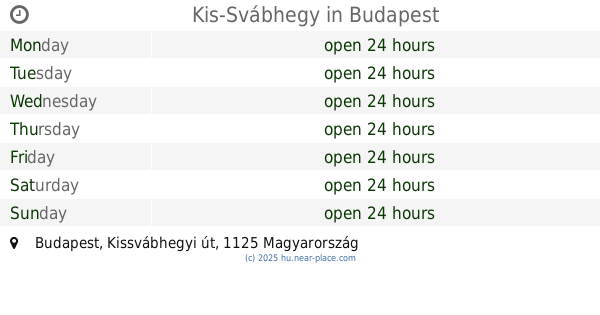
Kis-Svábhegy
Budapest, Kissvábhegyi út
Park
read more
1.717 km
Függetlenségi park
Budapest
Park
read more
1.737 km
Esperanto Parko
Budapest
Park
read more
1.748 km
Brasov Komondor park and nature trail
Budapest, Brassó út 80a
Park
read more
1.756 km
Eszperantó park, Zamenhof statue
Budapest
Park
read more
1.838 km
Szerb Ortodox Székesegyház Emlékmű
Budapest, Döbrentei utca 22
Park
read more
1.929 km
Európa Liget
Budapest, Európa liget
Park
read more
1.988 km
Corvin tér
I. kerület
Park
read more
2.006 km
Gellérthegy Jubileumi park
Budapest, Verejték utca 2
Park
read more
2.112 km
Szilágyi Dezső tér
I. kerület
Park
read more
2.171 km
Feneketlen-tavi Park
Budapest, Frankfurt sétány
Park
read more
2.313 km
Levendulás Park
Budapest, Kanizsai utca 28
Park
read more
2.434 km
Buty na brzegu Dunaju
Budapest, Idősebb Antall József rakpart
Park
read more
📑
all categories
Accounting
Administrative area level 1
Administrative area level 2
Airport
Amusement park
Aquarium
Art gallery
Atm
Bakery
Bank
Bar
Beauty salon
Bicycle store
Book store
Bowling alley
Bus station
Cafe
Campground
Car dealer
Car rental
Car repair
Car wash
Casino
Cemetery
Church
City hall
Clothing store
Colloquial area
Convenience store
Country
Courthouse
Dentist
Department store
Doctor
Electrician
Electronics store
Embassy
Finance
Fire station
Florist
Food
Funeral home
Furniture store
Gas station
General contractor
Grocery or supermarket
Gym
Hair care
Hardware store
Health
Hindu Temple
Home goods store
Hospital
Insurance agency
Intersection
Jewelry store
Laundry
Lawyer
Library
Light rail station
Liquor store
Local government office
Locality
Locksmith
Lodging
Meal delivery
Meal takeaway
Mosque
Movie rental
Movie theater
Moving company
Museum
Natural feature
Neighborhood
Night club
Painter
Park
Parking
Pet store
Pharmacy
Physiotherapist
Place of worship
Plumber
Point of interest
Police
Political
Post office
Premise
Real estate agency
Restaurant
Roofing contractor
Route
Rv park, camping
School
Shoe store
Shopping mall
Spa
Stadium
Storage
Store
Subpremise
Subway station
Supermarket
Synagogue
Taxi stand
Train station
Transit station
Travel agency
University
Veterinary care
Zoo
administrative area level 3
sublocality level 1
↑