Night club nearby Sashegyi Látogatóközpont
Hungary
Night club nearby Sashegyi Látogatóközpont
Sashegyi Látogatóközpont
Budapest, Tájék utca 24 Magyarország
contacts phone
:
+36
Latitude:
47.4826673
, Longitude:
19.0180511
read more
nearest Night club
575 m
PANORÁMÁS KILÁTÁS HEGYTETŐ U.
Budapest, Fátra tér 3
Night club
read more
840 m
Club Play
Budapest, Daróczi út 2
Night club
read more
890 m
GAS
Budapest, Karolina út 5
Night club
read more
1.772 km
A nagy lépcső teteje
Budapest, Czakó utca 1-3
Night club
read more
1.964 km
Csúszkás játszótér
Budapest, Keveháza utca 6
Night club
read more
1.971 km
Verem Room Escape Game
Budapest, Pauler utca 18
Night club
read more
2.045 km
Kalács Bár
Budapest, Fadrusz utca 2
Night club
read more
2.294 km
Öntőház udvar
Budapest, Ybl Miklós tér 4
Night club
read more
2.294 km
Öntőház udvar
Budapest, Ybl Miklós tér 2
Night club
read more
2.327 km
Romkert
Budapest, Döbrentei tér 9
Night club
read more
2.377 km
Vizivaros
Budapest
Night club
read more
2.441 km
SOTE Szilveszter 2010
Budapest, Szentháromság tér 6
Night club
read more
2.446 km
Fotopoint
Budapest, Jávorka Sándor lépcső
Night club
read more
2.517 km
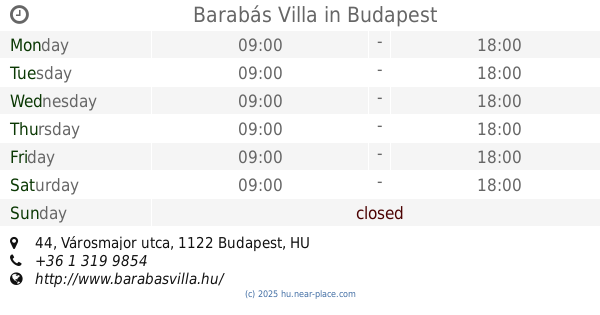
Barabás Villa
Budapest, Városmajor utca 44
Night club
read more
2.574 km
Jástszótér
Budapest, Mérnök utca 37
Night club
read more
2.592 km
Bercsényi Gödör Klub
Budapest, Bercsényi utca 28-30
Night club
read more
2.624 km
Karinthy Szalon
Budapest, Karinthy Frigyes út 22
Night club
read more
2.885 km
TRIP Hajó
Budapest, Szilágyi Dezső tér 2-es
Night club
read more
3.04 km
Secret Room
Budapest, Zrínyi utca 4
Night club
read more
3.12 km
Salsa Palace | Casinoteca, Budapest
Budapest, Arany János utca 10
Night club
read more
3.367 km
City Beer
Budapest, Károly körút 9
Night club
read more
3.369 km
Blind Mouse Stock Exchange Bar
Budapest, Paulay Ede utca 2
Night club
read more
3.369 km
Blind Mouse Exchange Tavern
Budapest, Paulay Ede utca 2
Night club
read more
3.376 km
G3 Gödör
Budapest, Király utca 8-10
Night club
read more
3.828 km
Coronita After
Budapest, Hengermalom út 133
Night club
read more
📑
all categories
Accounting
Administrative area level 1
Administrative area level 2
Airport
Amusement park
Aquarium
Art gallery
Atm
Bakery
Bank
Bar
Beauty salon
Bicycle store
Book store
Bowling alley
Bus station
Cafe
Campground
Car dealer
Car rental
Car repair
Car wash
Casino
Cemetery
Church
City hall
Clothing store
Colloquial area
Convenience store
Country
Courthouse
Dentist
Department store
Doctor
Electrician
Electronics store
Embassy
Finance
Fire station
Florist
Food
Funeral home
Furniture store
Gas station
General contractor
Grocery or supermarket
Gym
Hair care
Hardware store
Health
Hindu Temple
Home goods store
Hospital
Insurance agency
Intersection
Jewelry store
Laundry
Lawyer
Library
Light rail station
Liquor store
Local government office
Locality
Locksmith
Lodging
Meal delivery
Meal takeaway
Mosque
Movie rental
Movie theater
Moving company
Museum
Natural feature
Neighborhood
Night club
Painter
Park
Parking
Pet store
Pharmacy
Physiotherapist
Place of worship
Plumber
Point of interest
Police
Political
Post office
Premise
Real estate agency
Restaurant
Roofing contractor
Route
Rv park, camping
School
Shoe store
Shopping mall
Spa
Stadium
Storage
Store
Subpremise
Subway station
Supermarket
Synagogue
Taxi stand
Train station
Transit station
Travel agency
University
Veterinary care
Zoo
administrative area level 3
sublocality level 1
↑