Night club nearby Öntőház udvar
Hungary
Night club nearby Öntőház udvar
Öntőház udvar
4, Ybl Miklós tér, 1013, Budapest, HU Magyarország
contacts phone
:
+36
Latitude:
47.4955528
, Longitude:
19.0419054
larger map & directions
read more
nearest Night club
291 m
Vizivaros
Budapest
Night club
read more
531 m
A nagy lépcső teteje
Budapest, Czakó utca 1-3
Night club
read more
534 m
John Bull Sport Pub & Restaurant
Budapest, Apáczai Csere János utca 17
Night club
read more
606 m
KASINO
Budapest, Dorottya utca 2
Night club
read more
702 m
KRAFT
Budapest, Széchenyi István tér 7
Night club
read more
707 m
Budapest Clubs
Budapest, Ungarn, Zrínyi utca 3
Night club
read more
726 m
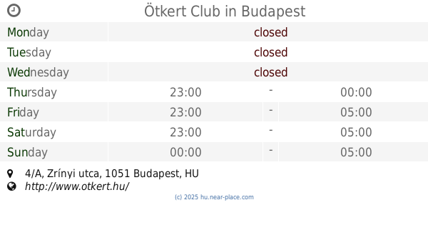
Ötkert Club
Budapest, Zrínyi utca 4/A
Night club
read more
754 m
Terasz
Budapest, Március 15. tér 2
Night club
read more
755 m
Secret Room
Budapest, Zrínyi utca 4
Night club
read more
777 m
Romkert
Budapest
Night club
read more
794 m
Romkert
Budapest, Döbrentei tér 9
Night club
read more
858 m
Salsa Palace | Casinoteca, Budapest
Budapest, Arany János utca 10
Night club
read more
866 m
Morison liget
Budapest, Párizsi utca 1
Night club
read more
867 m
TEREM Budapest
Budapest, Piarista köz 2
Night club
read more
885 m
Verem Room Escape Game
Budapest, Pauler utca 18
Night club
read more
942 m
TRIP Hajó
Budapest, Szilágyi Dezső tér 2-es
Night club
read more
948 m
Ic-Tour Rent A Bike&Electric Scooter
Budapest, Deák Ferenc tér
Night club
read more
973 m
SOTE Szilveszter 2010
Budapest, Szentháromság tér 6
Night club
read more
982 m
Akvárium
Budapest, Erzsébet tér 12
Night club
read more
982 m
Akvárium Klub
Budapest, Erzsébet tér 12
Night club
read more
996 m
Wamp Design Vásár
Budapest, József Attila utca 30
Night club
read more
1.003 km
Pink Orhid Thai Massage II.
Budapest, Irányi utca 12
Night club
read more
1.043 km
Hirdető oszlop
Budapest, Váci utca 43-47
Night club
read more
1.117 km
Belvàrosi Sörfesztivál
Budapest, Szabadság tér
Night club
read more
1.326 km
Toldi Klub
Budapest, Bajcsy-Zsilinszky út 38
Night club
read more
📑
all categories
Accounting
Administrative area level 1
Administrative area level 2
Airport
Amusement park
Aquarium
Art gallery
Atm
Bakery
Bank
Bar
Beauty salon
Bicycle store
Book store
Bowling alley
Bus station
Cafe
Campground
Car dealer
Car rental
Car repair
Car wash
Casino
Cemetery
Church
City hall
Clothing store
Colloquial area
Convenience store
Country
Courthouse
Dentist
Department store
Doctor
Electrician
Electronics store
Embassy
Finance
Fire station
Florist
Food
Funeral home
Furniture store
Gas station
General contractor
Grocery or supermarket
Gym
Hair care
Hardware store
Health
Hindu Temple
Home goods store
Hospital
Insurance agency
Intersection
Jewelry store
Laundry
Lawyer
Library
Light rail station
Liquor store
Local government office
Locality
Locksmith
Lodging
Meal delivery
Meal takeaway
Mosque
Movie rental
Movie theater
Moving company
Museum
Natural feature
Neighborhood
Night club
Painter
Park
Parking
Pet store
Pharmacy
Physiotherapist
Place of worship
Plumber
Point of interest
Police
Political
Post office
Premise
Real estate agency
Restaurant
Roofing contractor
Route
Rv park, camping
School
Shoe store
Shopping mall
Spa
Stadium
Storage
Store
Subpremise
Subway station
Supermarket
Synagogue
Taxi stand
Train station
Transit station
Travel agency
University
Veterinary care
Zoo
administrative area level 3
sublocality level 1
↑