Lodging nearby Hotel Kristály Imperial
Hungary
Lodging nearby Hotel Kristály Imperial
Hotel Kristály Imperial
Tata, Ady Endre utca 22 Hungary
contacts phone
:
+36
Latitude:
47.649966
, Longitude:
18.326793
read more
nearest Lodging
Kristály Imperial Hotel
Tata, Ady Endre utca 22
Lodging
read more
56 m
Tóvárosi apartman
Tata, Ady Endre út 48.
Lodging
read more
195 m
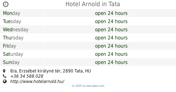
Hotel Arnold
Tata, Erzsébet királyné tér 8/a
Lodging
read more
221 m
Tóvárosi Fogadó
Tata, Malom utca 1
Lodging
read more
457 m
Leszbosz Fogadó
Tata, 7, Május 1. út 1/2
Lodging
read more
680 m
Platán Várárok Vendégház
Tata, Kastély tér 11
Lodging
read more
687 m
Platan Hotel
Tata, Kastély tér 6
Lodging
read more
715 m
Tata Panzió
Tata, Dobozi Mihály utca 2
Lodging
read more
715 m
Gottwald hotel Tata
Tata, Dobozi Mihály utca 2
Lodging
read more
777 m
Várkanyar Apartments
Tata, Hajdú utca 32
Lodging
read more
777 m
Várkanyar Apartmanok
Tata, Hajdú utca 32
Lodging
read more
794 m
Fekete Macska Panzió
Tata, Piac tér 25
Lodging
read more
795 m
Czérna Panzió
Tata, Kastély tér 3
Lodging
read more
795 m
Pension Czérna
Tata, Kastély tér 3
Lodging
read more
812 m
Black Cat Pizzeria Pension
Tata, Piac tér 25
Lodging
read more
812 m
Fekete Macska Pizzéria Panzio
Tata, Piac tér 25
Lodging
read more
889 m
Hotel Casablanca
Tata, Tópart sétány 3
Lodging
read more
997 m
Monika Panzió Tata
Tata, Tópart sétány 9
Lodging
read more
1.065 km
Tata Szálló - Tata
Tata, Agostyáni utca 78
Lodging
read more
1.065 km
Hostel Tata - Tata
Tata, Agostyáni utca 78
Lodging
read more
1.26 km
Hill Studio Tata
Tata, Kálvária utca 9
Lodging
read more
1.385 km
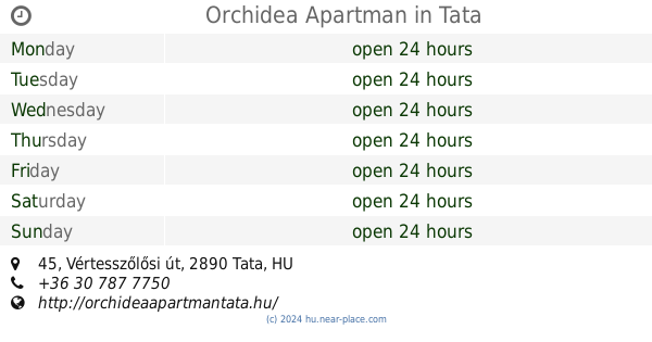
Orchidea Apartman
Tata, Vértesszőlősi út 45
Lodging
read more
1.775 km
Szent Iván Vendégház
Tata, Arany János utca
Lodging
read more
1.857 km
Öreg-Tó Club Hotel
Tata, Fáklya utca 4
Lodging
read more
1.971 km
Napsugár Apartman Tata
Tata, Fűzfa utca 5
Lodging
read more
📑
all categories
Accounting
Administrative area level 1
Administrative area level 2
Airport
Amusement park
Aquarium
Art gallery
Atm
Bakery
Bank
Bar
Beauty salon
Bicycle store
Book store
Bowling alley
Bus station
Cafe
Campground
Car dealer
Car rental
Car repair
Car wash
Casino
Cemetery
Church
City hall
Clothing store
Colloquial area
Convenience store
Country
Courthouse
Dentist
Department store
Doctor
Electrician
Electronics store
Embassy
Finance
Fire station
Florist
Food
Funeral home
Furniture store
Gas station
General contractor
Grocery or supermarket
Gym
Hair care
Hardware store
Health
Hindu Temple
Home goods store
Hospital
Insurance agency
Intersection
Jewelry store
Laundry
Lawyer
Library
Light rail station
Liquor store
Local government office
Locality
Locksmith
Lodging
Meal delivery
Meal takeaway
Mosque
Movie rental
Movie theater
Moving company
Museum
Natural feature
Neighborhood
Night club
Painter
Park
Parking
Pet store
Pharmacy
Physiotherapist
Place of worship
Plumber
Point of interest
Police
Political
Post office
Premise
Real estate agency
Restaurant
Roofing contractor
Route
Rv park, camping
School
Shoe store
Shopping mall
Spa
Stadium
Storage
Store
Subpremise
Subway station
Supermarket
Synagogue
Taxi stand
Train station
Transit station
Travel agency
University
Veterinary care
Zoo
administrative area level 3
sublocality level 1
↑