Lodging nearby Gottwald hotel Tata
Hungary
Lodging nearby Gottwald hotel Tata
Gottwald hotel Tata
2, Dobozi Mihály utca, 2890, Tata, HU Magyarország
contacts phone
:
+36
Latitude:
47.645463
, Longitude:
18.3336
larger map & directions
read more
nearest Lodging
6 m
Tata Panzió
Tata, Dobozi Mihály utca 2
Lodging
read more
177 m
Hotel Casablanca
Tata, Tópart sétány 3
Lodging
read more
283 m
Monika Panzió Tata
Tata, Tópart sétány 9
Lodging
read more
561 m
Tóvárosi Fogadó
Tata, Malom utca 1
Lodging
read more
680 m
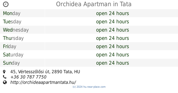
Orchidea Apartman
Tata, Vértesszőlősi út 45
Lodging
read more
690 m
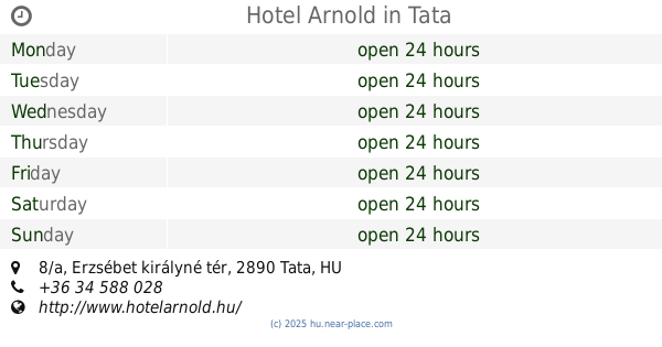
Hotel Arnold
Tata, Erzsébet királyné tér 8/a
Lodging
read more
715 m
Hotel Kristály Imperial
Tata, Ady Endre utca 22
Lodging
read more
715 m
Kristály Imperial Hotel
Tata, Ady Endre utca 22
Lodging
read more
766 m
Tóvárosi apartman
Tata, Ady Endre út 48.
Lodging
read more
803 m
Csendesapartman
Tata, Szegfű utca 32
Lodging
read more
808 m
Esély Budapest Alapítvány
Tata, Fáklya utca 4
Lodging
read more
1.145 km
Öreg-Tó Club Hotel
Tata, Fáklya utca 4
Lodging
read more
1.145 km
Öreg-Tó Club Hotel és Ifjúsági tábor
Tata, Fáklya utca 4
Lodging
read more
1.171 km
Leszbosz Fogadó
Tata, 7, Május 1. út 1/2
Lodging
read more
1.172 km
Öregtó Club, Étterem
Tata, Fáklya utca 4
Lodging
read more
1.226 km
The Corner House Panzió
Tata, Tulipán utca 1
Lodging
read more
1.256 km
Parti Panzió
Tata, Boróka utca 6
Lodging
read more
1.264 km
Napsugár Apartman Tata
Tata, Fűzfa utca 5
Lodging
read more
1.264 km
Tata Sunshine Apartment
Tata, Fűzfa utca 5
Lodging
read more
1.354 km
Apartment Tata
Tata, Fűzfa utca
Lodging
read more
1.394 km
Hill Studio Tata
Tata, Kálvária utca 9
Lodging
read more
1.622 km
Edita & Médy Fizetővendéglátó
Tata, Deák Ferenc utca 76
Lodging
read more
1.803 km
Szent Iván Vendégház
Tata, Arany János utca 24
Lodging
read more
1.845 km
Szent Iván Vendégház
Tata, Arany János utca
Lodging
read more
2.068 km
Honvéd Szálló
Tata, Fényes fasor
Lodging
read more
📑
all categories
Accounting
Administrative area level 1
Administrative area level 2
Airport
Amusement park
Aquarium
Art gallery
Atm
Bakery
Bank
Bar
Beauty salon
Bicycle store
Book store
Bowling alley
Bus station
Cafe
Campground
Car dealer
Car rental
Car repair
Car wash
Casino
Cemetery
Church
City hall
Clothing store
Colloquial area
Convenience store
Country
Courthouse
Dentist
Department store
Doctor
Electrician
Electronics store
Embassy
Finance
Fire station
Florist
Food
Funeral home
Furniture store
Gas station
General contractor
Grocery or supermarket
Gym
Hair care
Hardware store
Health
Hindu Temple
Home goods store
Hospital
Insurance agency
Intersection
Jewelry store
Laundry
Lawyer
Library
Light rail station
Liquor store
Local government office
Locality
Locksmith
Lodging
Meal delivery
Meal takeaway
Mosque
Movie rental
Movie theater
Moving company
Museum
Natural feature
Neighborhood
Night club
Painter
Park
Parking
Pet store
Pharmacy
Physiotherapist
Place of worship
Plumber
Point of interest
Police
Political
Post office
Premise
Real estate agency
Restaurant
Roofing contractor
Route
Rv park, camping
School
Shoe store
Shopping mall
Spa
Stadium
Storage
Store
Subpremise
Subway station
Supermarket
Synagogue
Taxi stand
Train station
Transit station
Travel agency
University
Veterinary care
Zoo
administrative area level 3
sublocality level 1
↑