Lodging nearby Árpád Hotel
Hungary
Lodging nearby Árpád Hotel
Árpád Hotel
20, Fő tér, 2800, Tatabánya, HU Magyarország
contacts phone
:
+36 34 310 299
website:
www.hotelarpad.hu
Latitude:
47.584041
, Longitude:
18.3985834
larger map & directions
read more
nearest Lodging
521 m
Szent-Borbála garzonház
Tatabánya
Lodging
read more
1.29 km
Hét vezér száló
Tatabánya, Újváros, Komáromi utca 42/B
Lodging
read more
2.579 km
Romantik Étterem és Panzió
Tatabánya, Felsőgallai út 6
Lodging
read more
2.781 km
Turul Utazási Iroda
Tatabánya L.u.2 Kormányhivatal 2.em
Lodging
read more
3.38 km
Sport Hotel és Étterem
Tatabánya, Szent Borbála út 11
Lodging
read more
4.124 km
Koldusszállás
Unnamed Rd,Tatabánya, 2800
Lodging
read more
4.266 km
Ajka Panzio
Tatabánya, Temetősor 15
Lodging
read more
4.294 km
Piroska Guesthouse
Vértesszőlős, Ady Endre utca 2/b
Lodging
read more
4.378 km
Start szálló
Tatabánya, Cementgyári út 1
Lodging
read more
4.545 km
Tulipán B szálló
Vértesszőlős, Valusek Dezső utca 27
Lodging
read more
4.545 km
Vár-lak Apartment
Vértesszőlős, Valusek út 27
Lodging
read more
4.772 km
Katalin Vendégház
Vértesszőlős, Ady Endre utca 63
Lodging
read more
5.348 km
Old Lake Golf Hotel
Tata, Old Lake Golf & Country Club, Remeteségpuszta
Lodging
read more
5.378 km
Old Lake Golf Club & Hotel****
Tata, Remeteségpuszta
Lodging
read more
5.473 km
Diana Golf Hotel
Tata, Remetesegpuszta
Lodging
read more
5.548 km
Sylvia Panzió Restaurant
Tata
Lodging
read more
6.275 km
Vitéz Apartman Tata
Tata, Ilona út 8
Lodging
read more
6.399 km
Csillagvirág Vendégházak
Vértestolna, Petőfi Sándor utca 59
Lodging
read more
6.886 km
Gottwald Hotel
Tata, Fekete út 1
Lodging
read more
7.769 km
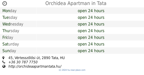
Orchidea Apartman
Tata, Vértesszőlősi út 45
Lodging
read more
8.388 km
Gottwald hotel Tata
Tata, Dobozi Mihály utca 2
Lodging
read more
8.732 km
Hacker Pusztai Tourist House
Várpalota, 47°31'01. 18°27'33., 8 5"N
Lodging
read more
9.448 km
Vadmacska Vadászház
Tatabánya
Lodging
read more
9.748 km
Vendégház Tardos
Tardos, Arany János utca 23
Lodging
read more
14.71 km
Marót-hegyi Sólyomfészek
Bajna, Pusztamaróti tábor
Lodging
read more
📑
all categories
Accounting
Administrative area level 1
Administrative area level 2
Airport
Amusement park
Aquarium
Art gallery
Atm
Bakery
Bank
Bar
Beauty salon
Bicycle store
Book store
Bowling alley
Bus station
Cafe
Campground
Car dealer
Car rental
Car repair
Car wash
Casino
Cemetery
Church
City hall
Clothing store
Colloquial area
Convenience store
Country
Courthouse
Dentist
Department store
Doctor
Electrician
Electronics store
Embassy
Finance
Fire station
Florist
Food
Funeral home
Furniture store
Gas station
General contractor
Grocery or supermarket
Gym
Hair care
Hardware store
Health
Hindu Temple
Home goods store
Hospital
Insurance agency
Intersection
Jewelry store
Laundry
Lawyer
Library
Light rail station
Liquor store
Local government office
Locality
Locksmith
Lodging
Meal delivery
Meal takeaway
Mosque
Movie rental
Movie theater
Moving company
Museum
Natural feature
Neighborhood
Night club
Painter
Park
Parking
Pet store
Pharmacy
Physiotherapist
Place of worship
Plumber
Point of interest
Police
Political
Post office
Premise
Real estate agency
Restaurant
Roofing contractor
Route
Rv park, camping
School
Shoe store
Shopping mall
Spa
Stadium
Storage
Store
Subpremise
Subway station
Supermarket
Synagogue
Taxi stand
Train station
Transit station
Travel agency
University
Veterinary care
Zoo
administrative area level 3
sublocality level 1
↑