Gas station nearby Skorpio-11 Kft.
Hungary
Gas station nearby Skorpio-11 Kft.
Skorpio-11 Kft.
Váchartyán, Fő út 9 Magyarország
contacts phone
:
+36
Latitude:
47.722937
, Longitude:
19.261486
read more
nearest Gas station
1.679 km
Duxler Kft Ipari Kiegészítők
Váchartyán
Gas station
read more
3.59 km
AVIA
Őrbottyán, Fő út 9733/2 hrsz
Gas station
read more
8.732 km
PENCOIL KFT üzemanyag, kávé, üdítő, sorsjegy
Penc, Rákóczi út
Gas station
read more
8.925 km
Well-Gas LPG- Autógáz Töltőállomás
Veresegyház, Szadai utca 17/c
Gas station
read more
9.103 km
SPAR Express OMV
Vác, Gödöllői út 1
Gas station
read more
9.717 km
Mobil Petrol
Vác, Szent László út 32
Gas station
read more
10.704 km
Shell
Dunakeszi, E77 M2
Gas station
read more
10.714 km
Shell
M2 2/a Főút
Gas station
read more
10.904 km
MOL
Vác, Deákvári fasor
Gas station
read more
12.074 km
MOL Benzinkút
Dunakeszi, 2-es sz. főút
Gas station
read more
13.229 km
Lukoil
Gödöllő, Jakabpusztai pihenő
Gas station
read more
13.274 km
MOL Benzinkút
Vác, Balassagyarmati út 1
Gas station
read more
13.606 km
Szikriszt Autósház E.V.
Vác, Balassagyarmati út 29
Gas station
read more
13.696 km
MOL Gas station
Fót, Keleti Márton utca
Gas station
read more
14.668 km
Lukoil
Dunakeszi, Fő út 2
Gas station
read more
14.725 km
Shell
Dunakeszi, Fő út 0120
Gas station
read more
15.394 km
Avia - Szentendre
Szentendre, Vasvári Pál u. 2794/16 hrsz.
Gas station
read more
15.637 km
MOL
Szentendre, Vasúti Villasor 6
Gas station
read more
16.465 km
MOL Benzinkút
Galgaguta, Kossuth út 27
Gas station
read more
17.1 km
OMV Töltőállomás
Szentendre, 11-es út 17. km
Gas station
read more
17.281 km
SPAR Express OMV
Szentendre, 11-es út
Gas station
read more
18.704 km
Magán
Budakalász, József Attila utca 75
Gas station
read more
18.714 km
RENAULT kút
Budakalász, József Attila utca
Gas station
read more
19.449 km
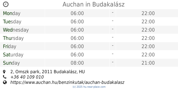
Auchan
Budakalász, Magyarország, Omszk park 2
Gas station
read more
20.829 km
OMV Töltőállomás
Budapest, Királyok útja 178
Gas station
read more
📑
all categories
Accounting
Administrative area level 1
Administrative area level 2
Airport
Amusement park
Aquarium
Art gallery
Atm
Bakery
Bank
Bar
Beauty salon
Bicycle store
Book store
Bowling alley
Bus station
Cafe
Campground
Car dealer
Car rental
Car repair
Car wash
Casino
Cemetery
Church
City hall
Clothing store
Colloquial area
Convenience store
Country
Courthouse
Dentist
Department store
Doctor
Electrician
Electronics store
Embassy
Finance
Fire station
Florist
Food
Funeral home
Furniture store
Gas station
General contractor
Grocery or supermarket
Gym
Hair care
Hardware store
Health
Hindu Temple
Home goods store
Hospital
Insurance agency
Intersection
Jewelry store
Laundry
Lawyer
Library
Light rail station
Liquor store
Local government office
Locality
Locksmith
Lodging
Meal delivery
Meal takeaway
Mosque
Movie rental
Movie theater
Moving company
Museum
Natural feature
Neighborhood
Night club
Painter
Park
Parking
Pet store
Pharmacy
Physiotherapist
Place of worship
Plumber
Point of interest
Police
Political
Post office
Premise
Real estate agency
Restaurant
Roofing contractor
Route
Rv park, camping
School
Shoe store
Shopping mall
Spa
Stadium
Storage
Store
Subpremise
Subway station
Supermarket
Synagogue
Taxi stand
Train station
Transit station
Travel agency
University
Veterinary care
Zoo
administrative area level 3
sublocality level 1
↑