Gas station nearby OMV Töltőállomás
Hungary
Gas station nearby OMV Töltőállomás
OMV Töltőállomás
178, Királyok útja, 1039, Budapest, HU Węgry
contacts phone
:
+36 1 240 5031
website:
www.omv.hu
Latitude:
47.59015
, Longitude:
19.06528
larger map & directions
read more
nearest Gas station
1.037 km
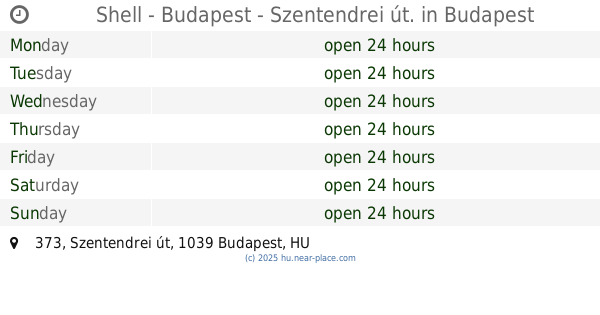
Shell - Budapest - Szentendrei út.
Budapest, Szentendrei út 373
Gas station
read more
1.11 km
Shell kút
Budapest, Batthyány utca 70
Gas station
read more
1.112 km
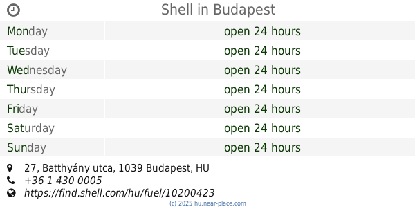
Shell
Budapest, Batthyány utca 27
Gas station
read more
1.333 km
Shell
Budapest, Madzsar József St, Szentendrei út 373
Gas station
read more
1.576 km
MOL Benzinkút
Budapest, Rákóczi utca 47
Gas station
read more
1.576 km
Mol - Budapest - Szentendrei út
Budapest, Rákóczi utca 47
Gas station
read more
1.586 km
Ciao Agip
Budapest, Rákóczi utca 47
Gas station
read more
1.719 km
OMV
Budapest, Rákóczi utca 38
Gas station
read more
2.049 km
MOL Benzinkút
Budapest, Váci út 84-90
Gas station
read more
2.13 km
Petrol Kft.
Budapest, Fóti út 43
Gas station
read more
2.136 km
OMV Töltőállomás
Budapest, Váci út 77
Gas station
read more
2.334 km
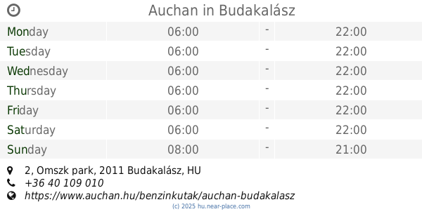
Auchan
Budakalász, Magyarország, Omszk park 2
Gas station
read more
2.394 km
Mol-Green
Budapest, Garam utca 2
Gas station
read more
2.709 km
Pilis Autogas Ltd.
Budakalász, Omszk Park, 1861/21 Auchan Bevásárlóközpont parkoló
Gas station
read more
2.709 km
Pilis Autógáz Kft.
Budakalász, Omszk Park, 1861/21 Auchan Bevásárlóközpont parkoló
Gas station
read more
3.03 km
OMV
Budapest, Váci út 16-18
Gas station
read more
3.405 km
Magán
Budakalász, József Attila utca 75
Gas station
read more
3.417 km
RENAULT kút
Budakalász, József Attila utca
Gas station
read more
3.885 km
Magán
Budapest, Bojtár utca 78
Gas station
read more
4.419 km
MOL
Budapest, Gémeskút utca 12
Gas station
read more
4.602 km
Shell
Budapest, Pozsonyi utca 1
Gas station
read more
4.705 km
MOL Benzinkút
Budapest, Szentendrei út 100
Gas station
read more
5.317 km
SPAR Express OMV
Budapest, OMV, Széchenyi tér 1
Gas station
read more
6.121 km
Shell
Dunakeszi, Fő út 0120
Gas station
read more
6.173 km
Lukoil
Dunakeszi, Fő út 2
Gas station
read more
📑
all categories
Accounting
Administrative area level 1
Administrative area level 2
Airport
Amusement park
Aquarium
Art gallery
Atm
Bakery
Bank
Bar
Beauty salon
Bicycle store
Book store
Bowling alley
Bus station
Cafe
Campground
Car dealer
Car rental
Car repair
Car wash
Casino
Cemetery
Church
City hall
Clothing store
Colloquial area
Convenience store
Country
Courthouse
Dentist
Department store
Doctor
Electrician
Electronics store
Embassy
Finance
Fire station
Florist
Food
Funeral home
Furniture store
Gas station
General contractor
Grocery or supermarket
Gym
Hair care
Hardware store
Health
Hindu Temple
Home goods store
Hospital
Insurance agency
Intersection
Jewelry store
Laundry
Lawyer
Library
Light rail station
Liquor store
Local government office
Locality
Locksmith
Lodging
Meal delivery
Meal takeaway
Mosque
Movie rental
Movie theater
Moving company
Museum
Natural feature
Neighborhood
Night club
Painter
Park
Parking
Pet store
Pharmacy
Physiotherapist
Place of worship
Plumber
Point of interest
Police
Political
Post office
Premise
Real estate agency
Restaurant
Roofing contractor
Route
Rv park, camping
School
Shoe store
Shopping mall
Spa
Stadium
Storage
Store
Subpremise
Subway station
Supermarket
Synagogue
Taxi stand
Train station
Transit station
Travel agency
University
Veterinary care
Zoo
administrative area level 3
sublocality level 1
↑