Gas station nearby Magán - Karancslapujtő
Hungary
Gas station nearby Magán - Karancslapujtő
Magán - Karancslapujtő
Karancslapujtő, Honvéd út 2 Magyarország
contacts phone
:
+36
Latitude:
48.1464733
, Longitude:
19.7467143
read more
nearest Gas station
24 m
Rool benzinkút
Karancslapujtő, Honvéd út 2/A
Gas station
read more
24 m
Rool gas station
Karancslapujtő, Honvéd út 2/A
Gas station
read more
6.315 km
Shell
Salgótarján, Fürdő út 1
Gas station
read more
7.16 km
MOL Benzinkút
Salgótarján, Rákóczi út 77-89
Gas station
read more
8.003 km
OMV Töltőállomás
Salgótarján, Rákóczi út 182
Gas station
read more
8.265 km
StopOil
Salgótarján, Rákóczi út 143
Gas station
read more
8.319 km
LPG Filling Station
Salgótarján, Haris köz 6
Gas station
read more
8.319 km
LPG Töltőállomás
Salgótarján, Haris köz 6
Gas station
read more
8.981 km
Normbenz
Salgótarján, Budapesti út 34
Gas station
read more
8.981 km
Lukoil
Salgótarján, Budapesti út 34
Gas station
read more
9.516 km
MOL Benzinkút
Salgótarján, Budapesti út
Gas station
read more
9.516 km
MOL Gas station
Salgótarján, Budapesti út
Gas station
read more
16.831 km
MOL Benzinkút
Bátonyterenye, 21.sz. fkl. út
Gas station
read more
17.346 km
MOL Benzinkút
Szécsény, Salgótarjáni út
Gas station
read more
18.912 km
Magán - Szécsény
Szécsény, Varsányi út 4
Gas station
read more
19.315 km
Lukoil
Bátonyterenye, Diák út
Gas station
read more
29.489 km
MOL Benzinkút
Pétervására, Orgona utca 6
Gas station
read more
34.321 km
MOL Benzinkút
Parádfürdő, 24.sz. fkl. út
Gas station
read more
39.928 km
Omv
Ózd, 3, Brassói út
Gas station
read more
40.894 km
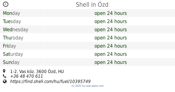
Shell
Ózd, Vas köz 1-2
Gas station
read more
52.634 km
Shell Tankstelle
Eger, Rákóczi Ferenc u 95
Gas station
read more
53.01 km
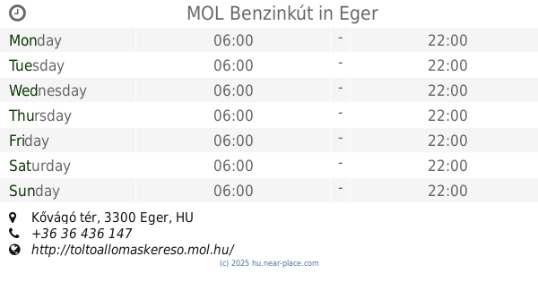
MOL Benzinkút
Eger, Kővágó tér
Gas station
read more
56.072 km
Shell
Eger, Rákóczi Ferenc u 95
Gas station
read more
56.367 km
MOL Töltőállomás
Eger, Mátyás király út
Gas station
read more
62.487 km
Mobil Petrol
Vác, Szent László út 32
Gas station
read more
📑
all categories
Accounting
Administrative area level 1
Administrative area level 2
Airport
Amusement park
Aquarium
Art gallery
Atm
Bakery
Bank
Bar
Beauty salon
Bicycle store
Book store
Bowling alley
Bus station
Cafe
Campground
Car dealer
Car rental
Car repair
Car wash
Casino
Cemetery
Church
City hall
Clothing store
Colloquial area
Convenience store
Country
Courthouse
Dentist
Department store
Doctor
Electrician
Electronics store
Embassy
Finance
Fire station
Florist
Food
Funeral home
Furniture store
Gas station
General contractor
Grocery or supermarket
Gym
Hair care
Hardware store
Health
Hindu Temple
Home goods store
Hospital
Insurance agency
Intersection
Jewelry store
Laundry
Lawyer
Library
Light rail station
Liquor store
Local government office
Locality
Locksmith
Lodging
Meal delivery
Meal takeaway
Mosque
Movie rental
Movie theater
Moving company
Museum
Natural feature
Neighborhood
Night club
Painter
Park
Parking
Pet store
Pharmacy
Physiotherapist
Place of worship
Plumber
Point of interest
Police
Political
Post office
Premise
Real estate agency
Restaurant
Roofing contractor
Route
Rv park, camping
School
Shoe store
Shopping mall
Spa
Stadium
Storage
Store
Subpremise
Subway station
Supermarket
Synagogue
Taxi stand
Train station
Transit station
Travel agency
University
Veterinary care
Zoo
administrative area level 3
sublocality level 1
↑