Gas station nearby MOL Töltőállomás
Hungary
Gas station nearby MOL Töltőállomás
MOL Töltőállomás
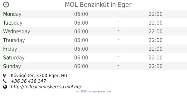
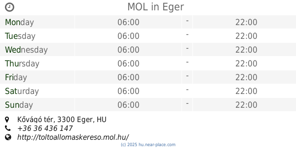
Mátyás király út, 3300, Eger, HU Magyarország
contacts phone
:
+36 36 517 312
website:
toltoallomaskereso.mol.hu
Latitude:
47.871369
, Longitude:
20.383269
larger map & directions
read more
nearest Gas station
MOL Benzinkút
Eger, Mátyás király út
Gas station
read more
MOL Tankstelle
Eger, Mátyás király út
Gas station
read more
545 m
OMV Töltőállomás
Eger, Mátyás király út 134
Gas station
read more
993 m
Shell
Eger, Rákóczi Ferenc u 95
Gas station
read more
1.621 km
Lukoil Töltőállomás
Eger, Kistályai út 18
Gas station
read more
1.621 km
Lukoil Gas station
Eger, Kistályai út 18
Gas station
read more
1.621 km
Lukoil Tankstelle
Eger, Kistályai út 18
Gas station
read more
1.945 km
MOL
Eger, Kistályai út 1
Gas station
read more
1.951 km
OIL!
Eger, Sas utca 94
Gas station
read more
1.955 km
MOL Benzinkút
Eger, Kistályai út 1
Gas station
read more
2.161 km
OMV Töltőállomás
Eger, Mátyás király út 2
Gas station
read more
2.161 km
OMV filling station
Eger, Mátyás király út 2
Gas station
read more
2.161 km
OMV
Eger, Mátyás király út 2
Gas station
read more
2.271 km
Eger Mol Telephely
Egerszalók, Unnamed Road
Gas station
read more
4.904 km
MOL Benzinkút
Eger, Kővágó tér
Gas station
read more
4.904 km
MOL
Eger, Kővágó tér
Gas station
read more
5.581 km
Shell Tankstelle
Eger, Rákóczi Ferenc u 95
Gas station
read more
5.866 km
MOL Gas station
Eger, II. Rákóczi Ferenc utca
Gas station
read more
11.811 km
MOL Benzinkút
Füzesabony, 3. sz. főút
Gas station
read more
11.811 km
Mol - Maklári út
Füzesabony, 3. sz. főút
Gas station
read more
13.643 km
Körtvély János Benzinkút
Füzesabony, Arany János utca 19
Gas station
read more
14.253 km
Oil
Füzesabony
Gas station
read more
17.236 km
Lukoil
Mezőkövesd, Lövői út 33
Gas station
read more
17.51 km
Magán - Kál
Kál, Kápolnai út 12
Gas station
read more
17.54 km
Sprint Olaj 2005 Kft.
Kál, Kápolnai út 12
Gas station
read more
📑
all categories
Accounting
Administrative area level 1
Administrative area level 2
Airport
Amusement park
Aquarium
Art gallery
Atm
Bakery
Bank
Bar
Beauty salon
Bicycle store
Book store
Bowling alley
Bus station
Cafe
Campground
Car dealer
Car rental
Car repair
Car wash
Casino
Cemetery
Church
City hall
Clothing store
Colloquial area
Convenience store
Country
Courthouse
Dentist
Department store
Doctor
Electrician
Electronics store
Embassy
Finance
Fire station
Florist
Food
Funeral home
Furniture store
Gas station
General contractor
Grocery or supermarket
Gym
Hair care
Hardware store
Health
Hindu Temple
Home goods store
Hospital
Insurance agency
Intersection
Jewelry store
Laundry
Lawyer
Library
Light rail station
Liquor store
Local government office
Locality
Locksmith
Lodging
Meal delivery
Meal takeaway
Mosque
Movie rental
Movie theater
Moving company
Museum
Natural feature
Neighborhood
Night club
Painter
Park
Parking
Pet store
Pharmacy
Physiotherapist
Place of worship
Plumber
Point of interest
Police
Political
Post office
Premise
Real estate agency
Restaurant
Roofing contractor
Route
Rv park, camping
School
Shoe store
Shopping mall
Spa
Stadium
Storage
Store
Subpremise
Subway station
Supermarket
Synagogue
Taxi stand
Train station
Transit station
Travel agency
University
Veterinary care
Zoo
administrative area level 3
sublocality level 1
↑