Food nearby Vadfaló
Hungary
Food nearby Vadfaló
Vadfaló
Macskások-Nyilasok dűlő, 2027, Dömös, HU Hungary
contacts phone
:
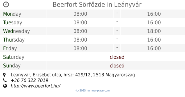
+36 20 599 9406
Latitude:
47.7557513
, Longitude:
18.9084832
larger map & directions
read more
nearest Food
6.095 km
Visegrádi Akadémiai Üdülő
Visegrád, Fő utca 45
Food
read more
10.087 km
Parti falatozo
Dunabogdány, Kossuth Lajos út 123
Food
read more
12.108 km
Tibesz húsbolt
Verőce, Rákóczi út 18
Food
read more
13.107 km
Tujafa
Esztergom, Petz testvérek utca 18
Food
read more
13.227 km
Major Stone Mountain
Pomáz, Kőhegy utca 1-6
Food
read more
13.227 km
Kőhegy Major
Pomáz, Kőhegy utca 1-6
Food
read more
13.449 km
Beerfort Sörfőzde
Leányvár, Erzsébet utca, hrsz: 429/12
Food
read more
13.581 km
UgrálniJó - Légvárbérlés otthonra
Szentendre, Anna utca 25
Food
read more
13.825 km
Rédai Dávid őstermelő
Tahitótfalu, Kisoroszi út
Food
read more
13.878 km
Szódakirály Kft.
Esztergom, Damjanich utca 127
Food
read more
13.938 km
Régi Borospince
Piliscsaba, Kenderesi út 38
Food
read more
14.009 km
Impala Food Kft.
Piliscsaba, József Attila köz 1
Food
read more
14.016 km
Szent István Pizza
Piliscsaba, József Attila köz 1-9
Food
read more
14.235 km
Duna Terasz
Leányfalu, Móricz Zsigmond út 136
Food
read more
14.342 km
Piliscsoport Nagykereskedelmi Zrt.
Pilisjászfalu, Bécsi út 32
Food
read more
14.902 km
Pörgelóci Puli Kennel
Szentendre, Vasvári Pál utca 8
Food
read more
15.017 km
Vega-Food 2.0 Kft.
Piliscsaba, Fő út 131
Food
read more
15.019 km
Jáber-Ker Kft.
Piliscsaba, Fő út 131
Food
read more
15.986 km
Lola Cukrászda
Szentendre, Dumtsa Jenő utca 5
Food
read more
15.986 km
Lola Confectionery
Szentendre, Dumtsa Jenő utca 5
Food
read more
16.116 km
Sarki Csemege
Szigetmonostor, Kossuth utca 1
Food
read more
16.503 km
Gazdabolt
Szentendre, Pannónia utca 1
Food
read more
16.785 km
Natur-Food Kft.
Budakalász, Pomázi út 68
Food
read more
18.476 km
Tefromeat Kft
Budakalász, Csapás utca 27
Food
read more
18.476 km
Tefromeat Ltd.
Budakalász, Csapás utca 27
Food
read more
📑
all categories
Accounting
Administrative area level 1
Administrative area level 2
Airport
Amusement park
Aquarium
Art gallery
Atm
Bakery
Bank
Bar
Beauty salon
Bicycle store
Book store
Bowling alley
Bus station
Cafe
Campground
Car dealer
Car rental
Car repair
Car wash
Casino
Cemetery
Church
City hall
Clothing store
Colloquial area
Convenience store
Country
Courthouse
Dentist
Department store
Doctor
Electrician
Electronics store
Embassy
Finance
Fire station
Florist
Food
Funeral home
Furniture store
Gas station
General contractor
Grocery or supermarket
Gym
Hair care
Hardware store
Health
Hindu Temple
Home goods store
Hospital
Insurance agency
Intersection
Jewelry store
Laundry
Lawyer
Library
Light rail station
Liquor store
Local government office
Locality
Locksmith
Lodging
Meal delivery
Meal takeaway
Mosque
Movie rental
Movie theater
Moving company
Museum
Natural feature
Neighborhood
Night club
Painter
Park
Parking
Pet store
Pharmacy
Physiotherapist
Place of worship
Plumber
Point of interest
Police
Political
Post office
Premise
Real estate agency
Restaurant
Roofing contractor
Route
Rv park, camping
School
Shoe store
Shopping mall
Spa
Stadium
Storage
Store
Subpremise
Subway station
Supermarket
Synagogue
Taxi stand
Train station
Transit station
Travel agency
University
Veterinary care
Zoo
administrative area level 3
sublocality level 1
↑