Food nearby Jáber-Ker Kft.
Hungary
Food nearby Jáber-Ker Kft.
Jáber-Ker Kft.
Piliscsaba, Fő út 131 Hungary
contacts phone
:
+36
Latitude:
47.632166
, Longitude:
18.827444
read more
nearest Food
2 m
Vega-Food 2.0 Kft.
Piliscsaba, Fő út 131
Food
read more
1.033 km
Szent István Pizza
Piliscsaba, József Attila köz 1-9
Food
read more
1.044 km
Impala Food Kft.
Piliscsaba, József Attila köz 1
Food
read more
1.71 km
Régi Borospince
Piliscsaba, Kenderesi út 38
Food
read more
4.164 km
Piliscsoport Nagykereskedelmi Zrt.
Pilisjászfalu, Bécsi út 32
Food
read more
5.53 km
Lovász Hidegkonyha
Pilisvörösvár, Fő utca 173
Food
read more
6.851 km
Barnabás Pince-Somló
Nagykovácsi, Berkenye utca 18
Food
read more
6.851 km
Barnabas Cellar Somló
Nagykovácsi, Berkenye utca 18
Food
read more
6.957 km
Bren Events Ltd Furniture rental company.
Perbál, Ipari park, 3
Food
read more
7.681 km
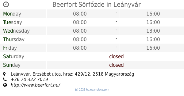
Beerfort Sörfőzde
Leányvár, Erzsébet utca, hrsz: 429/12
Food
read more
8.62 km
Gervai Pince
Budajenő, Ady Endre utca 3
Food
read more
8.801 km
Reisner Pince
Budajenő, Fő utca 11
Food
read more
9.03 km
Kucsik pincészet
Máriahalom, Szomori út 44
Food
read more
9.365 km
KOVÁCS PINCE
Tök, Pincesor 1334/1
Food
read more
11.324 km
Gravetti Kft.
Zsámbék, Petőfi S. u. 108.
Food
read more
13.165 km
Sania Homebrew
Páty
Food
read more
13.648 km
Gáborok Háza
Páty
Food
read more
14.603 km
Kalifa Kft.
Páty, Kerekdombi Ut 7.
Food
read more
15.019 km
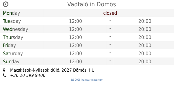
Vadfaló
Dömös, 056/3, Macskások-Nyilasok dűlő
Food
read more
15.215 km
Major Stone Mountain
Pomáz, Kőhegy utca 1-6
Food
read more
16.512 km
Bio Market Élelmiszer
Budapest, Nagybányai út 92
Food
read more
19.416 km
Milcsák pince
Bicske, Galagonyás dűlő
Food
read more
20.156 km
Lángos Land
Budapest, Fény utcai piac
Food
read more
20.25 km
Fű Juice Bar
Budapest, Retek utca 5
Food
read more
20.263 km
Palacsinta klub
Budapest, Retek utca 3
Food
read more
📑
all categories
Accounting
Administrative area level 1
Administrative area level 2
Airport
Amusement park
Aquarium
Art gallery
Atm
Bakery
Bank
Bar
Beauty salon
Bicycle store
Book store
Bowling alley
Bus station
Cafe
Campground
Car dealer
Car rental
Car repair
Car wash
Casino
Cemetery
Church
City hall
Clothing store
Colloquial area
Convenience store
Country
Courthouse
Dentist
Department store
Doctor
Electrician
Electronics store
Embassy
Finance
Fire station
Florist
Food
Funeral home
Furniture store
Gas station
General contractor
Grocery or supermarket
Gym
Hair care
Hardware store
Health
Hindu Temple
Home goods store
Hospital
Insurance agency
Intersection
Jewelry store
Laundry
Lawyer
Library
Light rail station
Liquor store
Local government office
Locality
Locksmith
Lodging
Meal delivery
Meal takeaway
Mosque
Movie rental
Movie theater
Moving company
Museum
Natural feature
Neighborhood
Night club
Painter
Park
Parking
Pet store
Pharmacy
Physiotherapist
Place of worship
Plumber
Point of interest
Police
Political
Post office
Premise
Real estate agency
Restaurant
Roofing contractor
Route
Rv park, camping
School
Shoe store
Shopping mall
Spa
Stadium
Storage
Store
Subpremise
Subway station
Supermarket
Synagogue
Taxi stand
Train station
Transit station
Travel agency
University
Veterinary care
Zoo
administrative area level 3
sublocality level 1
↑