Food nearby Aranka malom
Hungary
Food nearby Aranka malom
Aranka malom
Szent István út, 2060, Bicske, HU Hungary
contacts phone
:
+36
Latitude:
47.4856772
, Longitude:
18.6244655
larger map & directions
read more
nearest Food
1.606 km
Fehér Birtok
Bicske, Táborállás
Food
read more
2.965 km
Milcsák pince
Bicske, Galagonyás dűlő
Food
read more
4.872 km
Búzakalász 66 Felcsút Kft.
Felcsút, Fő utca 65
Food
read more
8.173 km
Etyeki Sörmanufaktúra
Etyek, 2091 Etyek, Botpuszta, Kolumbusz utca 1
Food
read more
9.341 km
Rókusfalvy Birtok
Etyek, Újhegy
Food
read more
9.355 km
Zarándokpince
Etyek, Szépvölgy
Food
read more
9.4 km
Debreczeni Pince
Etyek
Food
read more
9.56 km
Kácsor Kíra Cellar
Etyek, Újhegyi út HRSZ. 4154
Food
read more
9.56 km
Kácsor Kíra Pince
Etyek, Újhegyi út HRSZ. 4154
Food
read more
9.667 km
Tabajdi Pálinkafőzde
Tabajd, Petőfi utca 46
Food
read more
9.786 km
Chateâu Tabajd Winery
Tabajd
Food
read more
10.221 km
ANONYM PINCE
Etyek, Öreghegy 2635/3 hrsz
Food
read more
10.243 km
Wéber Pince Etyek
Etyek, Horváth utca 16
Food
read more
10.546 km
Pécseli Pince
Etyek, Öreghegyi út 48
Food
read more
10.979 km
Gravetti Kft.
Zsámbék, Petőfi S. u. 108.
Food
read more
11.008 km
Kattra Winery
Etyek, Biai Uti Borház
Food
read more
12.952 km
KOVÁCS PINCE
Tök, Pincesor 1334/1
Food
read more
13.506 km
Hollósy Birtok
Vál
Food
read more
14.48 km
Andrész Cukrászda
Biatorbágy, Szabadság út 37
Food
read more
14.928 km
Kalifa Kft.
Páty, Kerekdombi Ut 7.
Food
read more
15.34 km
Bren Events Ltd Furniture rental company.
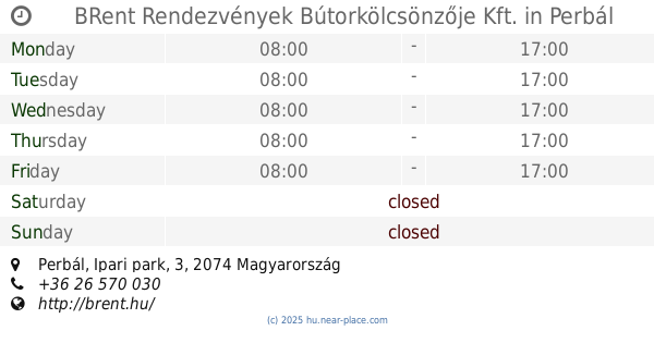
Perbál, Ipari park, 3
Food
read more
15.34 km
BRent Rendezvények Bútorkölcsönzője Kft.
Perbál, Ipari park, 3
Food
read more
15.37 km
Reisner Pince
Budajenő, Fő utca 11
Food
read more
15.607 km
Pusztazámori Baromfi Kft.
Pusztazámor, Móricz Zsigmond utca 54
Food
read more
15.718 km
Gervai Pince
Budajenő, Ady Endre utca 3
Food
read more
📑
all categories
Accounting
Administrative area level 1
Administrative area level 2
Airport
Amusement park
Aquarium
Art gallery
Atm
Bakery
Bank
Bar
Beauty salon
Bicycle store
Book store
Bowling alley
Bus station
Cafe
Campground
Car dealer
Car rental
Car repair
Car wash
Casino
Cemetery
Church
City hall
Clothing store
Colloquial area
Convenience store
Country
Courthouse
Dentist
Department store
Doctor
Electrician
Electronics store
Embassy
Finance
Fire station
Florist
Food
Funeral home
Furniture store
Gas station
General contractor
Grocery or supermarket
Gym
Hair care
Hardware store
Health
Hindu Temple
Home goods store
Hospital
Insurance agency
Intersection
Jewelry store
Laundry
Lawyer
Library
Light rail station
Liquor store
Local government office
Locality
Locksmith
Lodging
Meal delivery
Meal takeaway
Mosque
Movie rental
Movie theater
Moving company
Museum
Natural feature
Neighborhood
Night club
Painter
Park
Parking
Pet store
Pharmacy
Physiotherapist
Place of worship
Plumber
Point of interest
Police
Political
Post office
Premise
Real estate agency
Restaurant
Roofing contractor
Route
Rv park, camping
School
Shoe store
Shopping mall
Spa
Stadium
Storage
Store
Subpremise
Subway station
Supermarket
Synagogue
Taxi stand
Train station
Transit station
Travel agency
University
Veterinary care
Zoo
administrative area level 3
sublocality level 1
↑