Bakery nearby Kocsis Pékség
Hungary
Bakery nearby Kocsis Pékség
Kocsis Pékség
57, Drégelyvár utca, 1158, Budapest, HU Ungarn
contacts phone
:
+36
Latitude:
47.5354389
, Longitude:
19.133342
larger map & directions
read more
nearest Bakery
192 m
Négy Szabó pék kft.
Budapest, Drégelyvár utca 42
Bakery
read more
409 m
Tina pékség
Budapest, Nyírpalota út 2
Bakery
read more
846 m
Megyesi Cukraszda
Budapest
Bakery
read more
904 m
Tortarendelés
Budapest, Késmárk utca 14
Bakery
read more
966 m
Szabo Pék
Budapest, Zsókavár utca
Bakery
read more
1.098 km
crown Bakery
Budapest, Kolozsvár utca 2a
Bakery
read more
1.104 km
Csocsaj Pékség
Budapest, Erdőkerülő utca 3
Bakery
read more
1.148 km
Lumi Pékség
Budapest, Páskomliget utca 2
Bakery
read more
1.162 km
Lipóti Pékség
Budapest, Páskomliget utca 5
Bakery
read more
1.175 km
Vanilin Cukrászda
Budapest, Páskomliget utca 1
Bakery
read more
1.2 km
Fornetti bakery
Budapest, Nyírpalota út 52
Bakery
read more
1.2 km
Fornetti Látványpékség
Budapest, Nyírpalota út 52
Bakery
read more
1.294 km
Fanni Rétesház
Budapest, Kontyfa utca 4/a
Bakery
read more
1.308 km
Be My Cake by Sophie
Budapest, Telepes utca 96
Bakery
read more
1.618 km
Wedding Cake Budapest
Budapest, Bercsényi utca 16a
Bakery
read more
1.618 km
Esküvői Torta Budapest
Budapest, Bercsényi utca 16a
Bakery
read more
1.619 km
Pixie Pie
Budapest, Bercsényi utca 16a
Bakery
read more
1.834 km
Pólus Retro Cukrászda-Szamos Marcipán
Budapest, Szentmihályi út 131
Bakery
read more
1.93 km
Palotai Pékség Kft.
Budapest, Kozák tér 7
Bakery
read more
1.955 km
Bali pékség
Budapest, Rákos út 88-90
Bakery
read more
1.976 km
FFP Kft
Budapest, Baross utca 87a
Bakery
read more
1.988 km
Nani Pékség
Budapest, Rákos út 86
Bakery
read more
2.267 km
Porecs Pékség
Budapest, Csömöri út 90
Bakery
read more
2.344 km
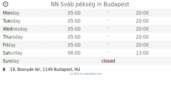
NN Sváb pékség
Budapest, Bosnyák tér 18
Bakery
read more
2.483 km
Mix-R Cukrászda
Budapest, Thököly út 176
Bakery
read more
📑
all categories
Accounting
Administrative area level 1
Administrative area level 2
Airport
Amusement park
Aquarium
Art gallery
Atm
Bakery
Bank
Bar
Beauty salon
Bicycle store
Book store
Bowling alley
Bus station
Cafe
Campground
Car dealer
Car rental
Car repair
Car wash
Casino
Cemetery
Church
City hall
Clothing store
Colloquial area
Convenience store
Country
Courthouse
Dentist
Department store
Doctor
Electrician
Electronics store
Embassy
Finance
Fire station
Florist
Food
Funeral home
Furniture store
Gas station
General contractor
Grocery or supermarket
Gym
Hair care
Hardware store
Health
Hindu Temple
Home goods store
Hospital
Insurance agency
Intersection
Jewelry store
Laundry
Lawyer
Library
Light rail station
Liquor store
Local government office
Locality
Locksmith
Lodging
Meal delivery
Meal takeaway
Mosque
Movie rental
Movie theater
Moving company
Museum
Natural feature
Neighborhood
Night club
Painter
Park
Parking
Pet store
Pharmacy
Physiotherapist
Place of worship
Plumber
Point of interest
Police
Political
Post office
Premise
Real estate agency
Restaurant
Roofing contractor
Route
Rv park, camping
School
Shoe store
Shopping mall
Spa
Stadium
Storage
Store
Subpremise
Subway station
Supermarket
Synagogue
Taxi stand
Train station
Transit station
Travel agency
University
Veterinary care
Zoo
administrative area level 3
sublocality level 1
↑