Bakery nearby Bali pékség
Coronavirus disease (COVID-19) Situation
confirmed cases
2230232
deaths
49048
Hungary
Bakery nearby Bali pékség
Bali pékség
Budapest, Rákos út 88-90 Ungarn
contacts phone
:
+36
Latitude:
47.5489079
, Longitude:
19.1165875
read more
nearest Bakery
64 m
Nani Pékség
Budapest, Rákos út 86
Bakery
read more
636 m
Palotai Bakeries Kft.
Budapest, Kozák tér 7
Bakery
read more
636 m
Palotai Pékség Kft.
Budapest, Kozák tér 7
Bakery
read more
875 m
crown Bakery
Budapest, Kolozsvár utca 2a
Bakery
read more
1.567 km
Hagyományőrző Pékség
Budapest, Virág utca 7
Bakery
read more
1.694 km
Pólus Retro Cukrászda-Szamos Marcipán
Budapest, Szentmihályi út 131
Bakery
read more
1.731 km
Lipóti Pékség
Budapest, Páskomliget utca 5
Bakery
read more
1.746 km
Fornetti Látványpékség
Budapest, Nyírpalota út 52
Bakery
read more
1.746 km
Fornetti bakery
Budapest, Nyírpalota út 52
Bakery
read more
1.751 km
Fanni Rétesház
Budapest, Kontyfa utca 4/a
Bakery
read more
1.759 km
Rétesbolt
Budapest, Fő út 64
Bakery
read more
1.79 km
Lumi Pékség
Budapest, Páskomliget utca 2
Bakery
read more
1.853 km
Tina pékség
Budapest, Nyírpalota út 2
Bakery
read more
1.889 km
Pékáru Vegyes Élelmiszer - Pékáru KKt
Budapest, Szent László út 164
Bakery
read more
1.942 km
Négy Szabó pék kft.
Budapest, Drégelyvár utca 42
Bakery
read more
1.952 km
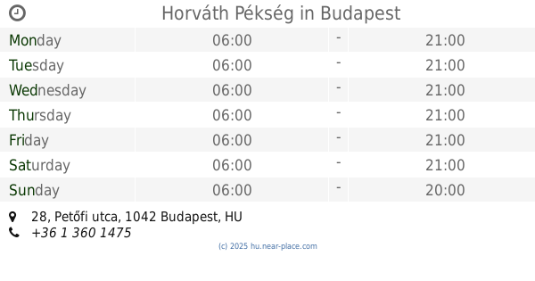
Horváth Pékség
Budapest, Petőfi utca 28
Bakery
read more
1.955 km
Kocsis Pékség
Budapest, 63, Drégelyvár utca 57
Bakery
read more
1.981 km
Sugar!
Újpest
Bakery
read more
2.026 km
Szabo Pék
Budapest, Zsókavár utca
Bakery
read more
2.041 km
Cortesi Pékség Pólus
Budapest, Szentmihályi út 131
Bakery
read more
2.044 km
Horváth Confectionery
Budapest, Petőfi utca 35
Bakery
read more
2.054 km
Megyesi Cukraszda
Budapest
Bakery
read more
2.277 km
Fornetti
Budapest, Kassai utca 36
Bakery
read more
2.349 km
Princess Fejedelmi Péksütemények
Budapest
Bakery
read more
2.525 km
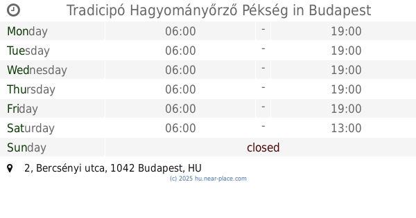
Tradicipó Hagyományőrző Pékség
Budapest, Bercsényi utca 2
Bakery
read more
📑
all categories
Accounting
Administrative area level 1
Administrative area level 2
Airport
Amusement park
Aquarium
Art gallery
Atm
Bakery
Bank
Bar
Beauty salon
Bicycle store
Book store
Bowling alley
Bus station
Cafe
Campground
Car dealer
Car rental
Car repair
Car wash
Casino
Cemetery
Church
City hall
Clothing store
Colloquial area
Convenience store
Country
Courthouse
Dentist
Department store
Doctor
Electrician
Electronics store
Embassy
Finance
Fire station
Florist
Food
Funeral home
Furniture store
Gas station
General contractor
Grocery or supermarket
Gym
Hair care
Hardware store
Health
Hindu Temple
Home goods store
Hospital
Insurance agency
Intersection
Jewelry store
Laundry
Lawyer
Library
Light rail station
Liquor store
Local government office
Locality
Locksmith
Lodging
Meal delivery
Meal takeaway
Mosque
Movie rental
Movie theater
Moving company
Museum
Natural feature
Neighborhood
Night club
Painter
Park
Parking
Pet store
Pharmacy
Physiotherapist
Place of worship
Plumber
Point of interest
Police
Political
Post office
Premise
Real estate agency
Restaurant
Roofing contractor
Route
Rv park, camping
School
Shoe store
Shopping mall
Spa
Stadium
Storage
Store
Subpremise
Subway station
Supermarket
Synagogue
Taxi stand
Train station
Transit station
Travel agency
University
Veterinary care
Zoo
administrative area level 3
sublocality level 1
↑