Gym nearby Honbu Dojo
Hungary
Gym nearby Honbu Dojo
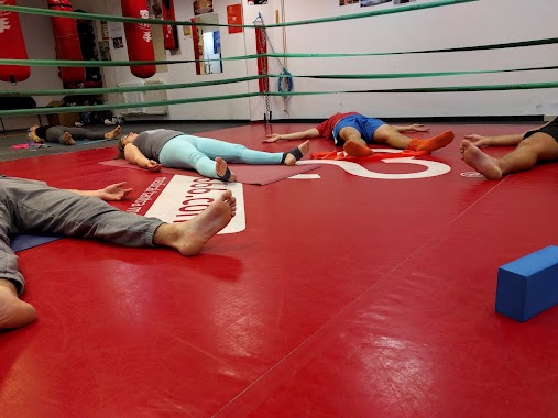
Honbu Dojo
Budapest, Pál utca 6 Hungría
contacts phone
:
+36
Latitude:
47.4877251
, Longitude:
19.06928
read more
nearest Gym
84 m
Farkasok Íjász Egyesület
Budapest, Mária utca 54
Gym
read more
87 m
Hobbiboksz SE edzöterme
Budapest, Mária utca 54
Gym
read more
445 m
Yogasanas Budapest
Budapest, 10, Salétrom utca
Gym
read more
462 m
T-REX Fitness
Budapest, Kis Salétrom utca 2
Gym
read more
478 m
Dance Center 6.em
Budapest, Liliom utca 43-45
Gym
read more
500 m
Modern Ving Tsun Kung-fu
Budapest, Rökk Szilárd utca 7
Gym
read more
602 m
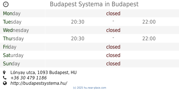
Budapest Systema
Budapest, Lónyay utca
Gym
read more
636 m
Adi Shakti Kundalini Yoga and Education Center
Budapest, Bakáts utca 5
Gym
read more
645 m
Fradibox Fight-Club Küzdősport Centrum
Budapest, Üllői út 66/a
Gym
read more
661 m
Nr1Fitness Kálvin 24/7
Budapest, Kecskeméti utca 14
Gym
read more
694 m
Színes Élet Stúdió
Budapest, Puskin utca 24
Gym
read more
722 m
The Vault
Budapest, Bokréta utca
Gym
read more
734 m
Titan Kickness - Kickbox
Budapest, Tűzoltó utca 27
Gym
read more
738 m
Szentkirályi Sport Egyesület
Budapest, 10, Szentkirályi utca
Gym
read more
761 m
Rokko Gym
Budapest, Angyal u 7
Gym
read more
777 m
Katana SE Shoryumon Karate Dojo
Budapest, Angyal utca 7/a
Gym
read more
1000 m
Felkelő Nap Háza Stúdió
Budapest, Rákóczi út 36
Gym
read more
1.044 km
AUM Yoga Astoria
Budapest, Károly körút 3/a
Gym
read more
1.045 km
Bikram Jóga Központ
Budapest, Károly körút 1
Gym
read more
1.045 km
AUM Jóga IRODA
Budapest, Károly körút 1
Gym
read more
1.181 km
Immo1 Downtown Semmelweis Street
Budapest, Semmelweis utca 15
Gym
read more
1.253 km
BME MAFC Aikido Klub
Budapest, Bertalan Lajos utca 2
Gym
read more
1.267 km
NOVA Speedfitness Studio
Budapest, Márton utca 35/b
Gym
read more
1.277 km
Mandala Jóga Deáktér
Budapest, Károly körút 7
Gym
read more
1.297 km
Sani-Prevent Musculoskeletal Center
Budapest, Tűzoltó utca 80
Gym
read more
📑
all categories
Accounting
Administrative area level 1
Administrative area level 2
Airport
Amusement park
Aquarium
Art gallery
Atm
Bakery
Bank
Bar
Beauty salon
Bicycle store
Book store
Bowling alley
Bus station
Cafe
Campground
Car dealer
Car rental
Car repair
Car wash
Casino
Cemetery
Church
City hall
Clothing store
Colloquial area
Convenience store
Country
Courthouse
Dentist
Department store
Doctor
Electrician
Electronics store
Embassy
Finance
Fire station
Florist
Food
Funeral home
Furniture store
Gas station
General contractor
Grocery or supermarket
Gym
Hair care
Hardware store
Health
Hindu Temple
Home goods store
Hospital
Insurance agency
Intersection
Jewelry store
Laundry
Lawyer
Library
Light rail station
Liquor store
Local government office
Locality
Locksmith
Lodging
Meal delivery
Meal takeaway
Mosque
Movie rental
Movie theater
Moving company
Museum
Natural feature
Neighborhood
Night club
Painter
Park
Parking
Pet store
Pharmacy
Physiotherapist
Place of worship
Plumber
Point of interest
Police
Political
Post office
Premise
Real estate agency
Restaurant
Roofing contractor
Route
Rv park, camping
School
Shoe store
Shopping mall
Spa
Stadium
Storage
Store
Subpremise
Subway station
Supermarket
Synagogue
Taxi stand
Train station
Transit station
Travel agency
University
Veterinary care
Zoo
administrative area level 3
sublocality level 1
↑