Cafe nearby Nemzeti Dohánybolt
Coronavirus disease (COVID-19) Situation
confirmed cases
2230232
deaths
49048
Hungary
Cafe nearby Nemzeti Dohánybolt
Nemzeti Dohánybolt
368, Pesti út, 1171, Budapest, HU Magyarország
contacts phone
:
+36
Latitude:
47.4692239
, Longitude:
19.2947445
larger map & directions
read more
nearest Cafe
186 m
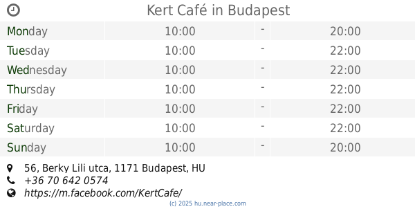
Kert Café
Budapest, Berky Lili utca 56
Cafe
read more
3.177 km
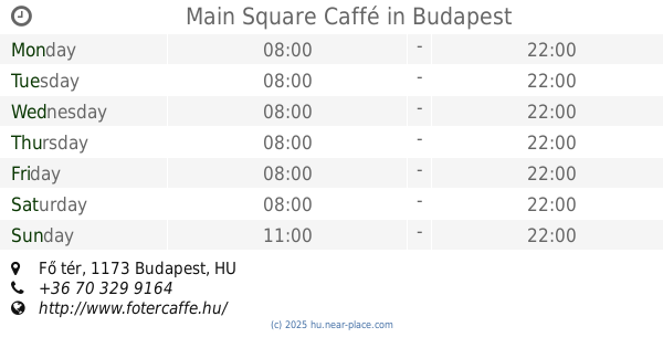
Main Square Caffé
Budapest, Fő tér
Cafe
read more
3.184 km
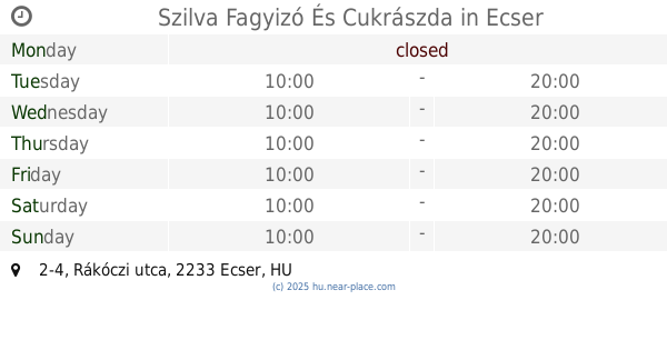
Szilva Fagyizó És Cukrászda
Ecser, 2233, Rákóczi utca 2-4
Cafe
read more
3.292 km
K-Ati-Ca Fagyizó
Budapest, Naplás út 55
Cafe
read more
3.434 km
Liget Café
Budapest, Hősök tere 18
Cafe
read more
3.46 km
Törzshely
Budapest, Ferihegyi út 26
Cafe
read more
3.915 km
Ani Büfé
Pécel, Maglódi út 22
Cafe
read more
4.275 km
Régi Álom Tea-, Kávéház
Pécel, Rákos utca 1
Cafe
read more
4.552 km
Alfa Cafe
Maglód, Bajcsy-Zsilinszky utca 71
Cafe
read more
4.688 km
Camden Food Co.
Budapest, 1185, Liszt Ferenc tér
Cafe
read more
4.76 km
Café Ritazza
Budapest
Cafe
read more
4.768 km
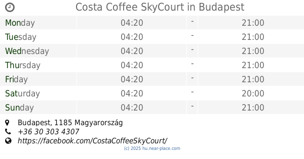
Costa Coffee SkyCourt
Budapest
Cafe
read more
4.768 km
Costa
Budapest
Cafe
read more
5.042 km
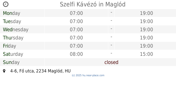
Szelfi Kávézó
Maglód, Fő utca 4-6
Cafe
read more
9.281 km
Cafe Rose
Kerepes, Szabadság út 66
Cafe
read more
10.38 km
Italdiszkont
Üllő, Ócsai út 41
Cafe
read more
11.323 km
Ízek Háza
Budapest, Kossuth tér 2
Cafe
read more
11.672 km
Édeském Cukrászda
Budapest, Ady Endre út 57
Cafe
read more
12.332 km
Coffeeshop Company in Árkád
Budapest, Árkád
Cafe
read more
12.596 km
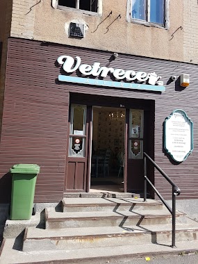
Vetrece Kávézó
Budapest, Corvin körút 44
Cafe
read more
14.142 km
Stádium Kiadó
Budapest, Igló utca 6
Cafe
read more
14.957 km
Monarchy Strudel House
Gödöllő, Szabadság tér 5
Cafe
read more
15.191 km
Smankerli Cukrászda és Kávézó
Budapest, Róna utca 161
Cafe
read more
17.176 km
The Hatter
Monor, Ady Endre utca 17
Cafe
read more
18.919 km
cafe del zorro
Budapest, Külső Szilágyi út 70
Cafe
read more
📑
all categories
Accounting
Administrative area level 1
Administrative area level 2
Airport
Amusement park
Aquarium
Art gallery
Atm
Bakery
Bank
Bar
Beauty salon
Bicycle store
Book store
Bowling alley
Bus station
Cafe
Campground
Car dealer
Car rental
Car repair
Car wash
Casino
Cemetery
Church
City hall
Clothing store
Colloquial area
Convenience store
Country
Courthouse
Dentist
Department store
Doctor
Electrician
Electronics store
Embassy
Finance
Fire station
Florist
Food
Funeral home
Furniture store
Gas station
General contractor
Grocery or supermarket
Gym
Hair care
Hardware store
Health
Hindu Temple
Home goods store
Hospital
Insurance agency
Intersection
Jewelry store
Laundry
Lawyer
Library
Light rail station
Liquor store
Local government office
Locality
Locksmith
Lodging
Meal delivery
Meal takeaway
Mosque
Movie rental
Movie theater
Moving company
Museum
Natural feature
Neighborhood
Night club
Painter
Park
Parking
Pet store
Pharmacy
Physiotherapist
Place of worship
Plumber
Point of interest
Police
Political
Post office
Premise
Real estate agency
Restaurant
Roofing contractor
Route
Rv park, camping
School
Shoe store
Shopping mall
Spa
Stadium
Storage
Store
Subpremise
Subway station
Supermarket
Synagogue
Taxi stand
Train station
Transit station
Travel agency
University
Veterinary care
Zoo
administrative area level 3
sublocality level 1
↑