Cafe nearby Gradski Vrt Stadion
Coronavirus disease (COVID-19) Situation
confirmed cases
2230232
deaths
49048
Hungary
Cafe nearby Gradski Vrt Stadion
Gradski Vrt Stadion
Harkány, Zsigmondy sétány Hungary
contacts phone
:
+36
Latitude:
45.8491545
, Longitude:
18.2372209
read more
nearest Cafe
3.891 km
Zombori Söröző
Siklós, Harkányi út
Cafe
read more
4.539 km
Vár kavézó
Siklós, Vajda János tér 7
Cafe
read more
4.77 km
City Café
Siklós, 24, Felszabadulás utca 22
Cafe
read more
13.644 km
Italbolt
Szőkéd, József Attila utca 8
Cafe
read more
17.336 km
Caffe&Pasta
Villány, Damjanich János utca
Cafe
read more
24.013 km
Park Pavilon Cafe
Pécs, Szilárd Leó park
Cafe
read more
24.114 km
Balázs Café
Pécs, Péchy Blanka tér 1
Cafe
read more
24.13 km
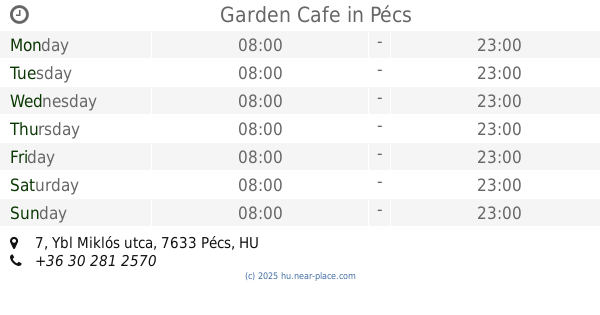
Garden Cafe
Pécs, Ybl Miklós utca 7
Cafe
read more
24.153 km
Caffé Grande Italia
Pécs, 48, Mártírok útja
Cafe
read more
24.153 km
Caffé Grande Italia
Pécs, Mártírok útja 48
Cafe
read more
24.228 km
Baltás Joe Kókányoló Nagymester
Pécs, Verseny utca 2
Cafe
read more
24.455 km
Magda Confectionery
Pécs, 4, Kandó Kálmán utca
Cafe
read more
24.455 km
Magda Cukrászda
Pécs, 4, Kandó Kálmán utca
Cafe
read more
24.747 km
Uránvárodi Bbá
Pécs, Magyarürögi út 2
Cafe
read more
24.767 km
Miller's Café
Pécs, Bajcsy-Zsilinszky utca 11
Cafe
read more
24.783 km
Cafe Mobile
Pécs, Bajcsy-Zsilinszky utca 6
Cafe
read more
24.797 km
Nespresso
Pécs, Czinderi utca 14
Cafe
read more
24.86 km
Melegkonyhás kávézó
Pécs, Rákóczi út 46
Cafe
read more
24.9 km
Coffeeshop Company University Pécs
Pécs, Szigeti út 37
Cafe
read more
24.9 km
Coffeeshop Company
Pécs, Szigeti út 37
Cafe
read more
24.939 km
Fine Cofee and Bakery
Pécs, Szigeti út 12
Cafe
read more
24.945 km
Sliven Ring & Caffe
Pécs, Mezőszél utca 1
Cafe
read more
24.969 km
Casablanca
Pécs, Irgalmasok utcája 20
Cafe
read more
24.989 km
Mozaiq Cafe
Pécs, Hungária utca 53/1
Cafe
read more
28.918 km
King Bakery and Pizzeria
Szentlőrinc, Munkácsy Mihály utca 13
Cafe
read more
📑
all categories
Accounting
Administrative area level 1
Administrative area level 2
Airport
Amusement park
Aquarium
Art gallery
Atm
Bakery
Bank
Bar
Beauty salon
Bicycle store
Book store
Bowling alley
Bus station
Cafe
Campground
Car dealer
Car rental
Car repair
Car wash
Casino
Cemetery
Church
City hall
Clothing store
Colloquial area
Convenience store
Country
Courthouse
Dentist
Department store
Doctor
Electrician
Electronics store
Embassy
Finance
Fire station
Florist
Food
Funeral home
Furniture store
Gas station
General contractor
Grocery or supermarket
Gym
Hair care
Hardware store
Health
Hindu Temple
Home goods store
Hospital
Insurance agency
Intersection
Jewelry store
Laundry
Lawyer
Library
Light rail station
Liquor store
Local government office
Locality
Locksmith
Lodging
Meal delivery
Meal takeaway
Mosque
Movie rental
Movie theater
Moving company
Museum
Natural feature
Neighborhood
Night club
Painter
Park
Parking
Pet store
Pharmacy
Physiotherapist
Place of worship
Plumber
Point of interest
Police
Political
Post office
Premise
Real estate agency
Restaurant
Roofing contractor
Route
Rv park, camping
School
Shoe store
Shopping mall
Spa
Stadium
Storage
Store
Subpremise
Subway station
Supermarket
Synagogue
Taxi stand
Train station
Transit station
Travel agency
University
Veterinary care
Zoo
administrative area level 3
sublocality level 1
↑