Cafe nearby Mozaiq Cafe
Coronavirus disease (COVID-19) Situation
confirmed cases
2230232
deaths
49048
Hungary
Cafe nearby Mozaiq Cafe
Mozaiq Cafe
Pécs, Hungária utca 53/1 Magyarország
contacts phone
:
+36
Latitude:
46.0733227
, Longitude:
18.2136999
read more
nearest Cafe
75 m
Sliven Ring & Caffe
Pécs, Mezőszél utca 1
Cafe
read more
75 m
Szliven Ring & Caffe
Pécs, Mezőszél utca 1
Cafe
read more
182 m
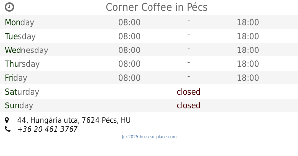
Coffee Corner
Pécs, Hungária utca 44
Cafe
read more
182 m
Corner Coffee
Pécs, Hungária utca 44
Cafe
read more
477 m
Block
Pécs, a, Ifjúság útja 9
Cafe
read more
477 m
Block Coffee Room
Pécs, a, Ifjúság útja 9
Cafe
read more
551 m
Fine Cofee and Bakery
Pécs, Szigeti út 12
Cafe
read more
615 m
Magda Confectionery
Pécs, 4, Kandó Kálmán utca
Cafe
read more
615 m
Magda Cukrászda
Pécs, 4, Kandó Kálmán utca
Cafe
read more
620 m
Coffeeshop Company University Pécs
Pécs, Szigeti út 37
Cafe
read more
620 m
Coffeeshop Company
Pécs, Szigeti út 37
Cafe
read more
621 m
Next Step Coffee
Pécs, Ferencesek utcája 41
Cafe
read more
781 m
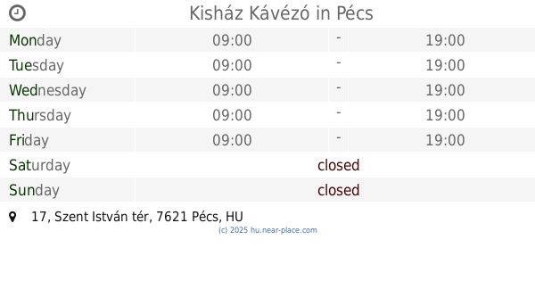
Kisház Kávézó
Pécs, Szent István tér 17
Cafe
read more
781 m
Little House Cafe
Pécs, Szent István tér 17
Cafe
read more
829 m
Csalogány Presszó
Pécs, Kacsóh Pongrác utca 2
Cafe
read more
853 m
Büfé
Pécs, Boszorkány út 2
Cafe
read more
870 m
Caffé Grande Italia
Pécs, 48, Mártírok útja
Cafe
read more
870 m
Caffé Grande Italia
Pécs, Mártírok útja 48
Cafe
read more
919 m
Magtár Kávézó
Pécs, Szent István tér 6
Cafe
read more
998 m
Kisülés Kávéműhely
Pécs, Ferencesek utcája 5
Cafe
read more
1.243 km
Balázs Café
Pécs, Péchy Blanka tér 1
Cafe
read more
1.34 km
Wannabe Cafe & Bar
Pécs, Perczel Miklós utca 14
Cafe
read more
1.435 km
Zsanér
Pécs, 7621, Király utca 26
Cafe
read more
1.538 km
Cake & Coffee Specialty Bistro
Pécs, Király utca 36
Cafe
read more
2.059 km
Coffee Tettye
Pécs, Tettye utca 46
Cafe
read more
📑
all categories
Accounting
Administrative area level 1
Administrative area level 2
Airport
Amusement park
Aquarium
Art gallery
Atm
Bakery
Bank
Bar
Beauty salon
Bicycle store
Book store
Bowling alley
Bus station
Cafe
Campground
Car dealer
Car rental
Car repair
Car wash
Casino
Cemetery
Church
City hall
Clothing store
Colloquial area
Convenience store
Country
Courthouse
Dentist
Department store
Doctor
Electrician
Electronics store
Embassy
Finance
Fire station
Florist
Food
Funeral home
Furniture store
Gas station
General contractor
Grocery or supermarket
Gym
Hair care
Hardware store
Health
Hindu Temple
Home goods store
Hospital
Insurance agency
Intersection
Jewelry store
Laundry
Lawyer
Library
Light rail station
Liquor store
Local government office
Locality
Locksmith
Lodging
Meal delivery
Meal takeaway
Mosque
Movie rental
Movie theater
Moving company
Museum
Natural feature
Neighborhood
Night club
Painter
Park
Parking
Pet store
Pharmacy
Physiotherapist
Place of worship
Plumber
Point of interest
Police
Political
Post office
Premise
Real estate agency
Restaurant
Roofing contractor
Route
Rv park, camping
School
Shoe store
Shopping mall
Spa
Stadium
Storage
Store
Subpremise
Subway station
Supermarket
Synagogue
Taxi stand
Train station
Transit station
Travel agency
University
Veterinary care
Zoo
administrative area level 3
sublocality level 1
↑