Supermarket nearby Tesco
Hungary
Supermarket nearby Tesco
Tesco
Nagykőrös, Ceglédi út 32 Hungary
contacts phone
:
+36
Latitude:
47.04389
, Longitude:
19.78378
read more
nearest Supermarket
361 m
TESCO Hipermarket
Nagykőrös, Ceglédi út 32
Supermarket
read more
542 m
SPAR Szupermarket
Nagykőrös, Ceglédi út 14
Supermarket
read more
1.192 km
Pumukli Üzletház Nagykőrös
Nagykőrös, Biczó Géza utca 1
Supermarket
read more
1.229 km
Lord Kutya-macska Kisállateledel
Nagykőrös, Kossuth Lajos út
Supermarket
read more
1.556 km
ALDI
Nagykőrös, Kossuth Lajos út 49-51
Supermarket
read more
1.728 km
Piac
Nagykőrös, Kálvin tér 11
Supermarket
read more
2.648 km
Lidl
Nagykorös, Kecskeméti Straße 73.
Supermarket
read more
2.691 km
Penny Market
Nagykőrös, Kecskeméti u. 86.
Supermarket
read more
10.401 km
Önért Vegyeskereskedés ABC
Kecskemét, Mályva utca 37
Supermarket
read more
13.358 km
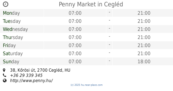
Penny Market
Cegléd, Kőrösi út 38
Supermarket
read more
14.104 km
SPAR
Cegléd, 9-10, Kossuth tér
Supermarket
read more
14.104 km
SPAR Market
Cegléd, 9-10, Kossuth tér
Supermarket
read more
14.25 km
Kézműves ABC
Cegléd, Kossuth Ferenc utca 3
Supermarket
read more
14.559 km
Lidl
Cegléd
Supermarket
read more
15.23 km
TESCO Hipermarket
Kecskemét, Talfája köz 1
Supermarket
read more
15.23 km
TESCO Hipermarket
Kecskemét, Talfája 1
Supermarket
read more
15.515 km
ALDI
Kecskemét, Szent István körút 30
Supermarket
read more
15.558 km
Lidl
Kecskemét, Szolnoki út 18
Supermarket
read more
15.701 km
Penny Market
Kecskemét, Kodály Zoltán tér 8.
Supermarket
read more
16.206 km
SPAR Szupermarket
Kecskemét, Március 15. utca 5
Supermarket
read more
16.296 km
ALDI Kecskemét
Kecskemét, Rákóczi út 13/A
Supermarket
read more
16.296 km
ALDI
Kecskemét, Rákóczi út 13/A
Supermarket
read more
16.301 km
Univer
Kecskemét, Budai utca 5
Supermarket
read more
16.395 km
SPAR Szupermarket
Kecskemét, Nagykőrösi utca 2
Supermarket
read more
16.489 km
Golden Vegyesbolt
Kecskemét
Supermarket
read more
📑
all categories
Accounting
Administrative area level 1
Administrative area level 2
Airport
Amusement park
Aquarium
Art gallery
Atm
Bakery
Bank
Bar
Beauty salon
Bicycle store
Book store
Bowling alley
Bus station
Cafe
Campground
Car dealer
Car rental
Car repair
Car wash
Casino
Cemetery
Church
City hall
Clothing store
Colloquial area
Convenience store
Country
Courthouse
Dentist
Department store
Doctor
Electrician
Electronics store
Embassy
Finance
Fire station
Florist
Food
Funeral home
Furniture store
Gas station
General contractor
Grocery or supermarket
Gym
Hair care
Hardware store
Health
Hindu Temple
Home goods store
Hospital
Insurance agency
Intersection
Jewelry store
Laundry
Lawyer
Library
Light rail station
Liquor store
Local government office
Locality
Locksmith
Lodging
Meal delivery
Meal takeaway
Mosque
Movie rental
Movie theater
Moving company
Museum
Natural feature
Neighborhood
Night club
Painter
Park
Parking
Pet store
Pharmacy
Physiotherapist
Place of worship
Plumber
Point of interest
Police
Political
Post office
Premise
Real estate agency
Restaurant
Roofing contractor
Route
Rv park, camping
School
Shoe store
Shopping mall
Spa
Stadium
Storage
Store
Subpremise
Subway station
Supermarket
Synagogue
Taxi stand
Train station
Transit station
Travel agency
University
Veterinary care
Zoo
administrative area level 3
sublocality level 1
↑