Supermarket nearby SPAR Szupermarket
Hungary
Supermarket nearby SPAR Szupermarket
SPAR Szupermarket
Ajka, Ifjúság utca 9 Magyarország
contacts phone
:
+36
Latitude:
47.10852
, Longitude:
17.55111
read more
nearest Supermarket
444 m
Penny
Ajka, Fő út 54
Supermarket
read more
444 m
Penny Market
Ajka, Fő út 54
Supermarket
read more
613 m
Tesco
Ajka, Fő út 66
Supermarket
read more
662 m
TESCO hypermarket Ajka
Ajka, Fő út 66
Supermarket
read more
662 m
TESCO Ajka Hipermarket
Ajka, Fő út 66
Supermarket
read more
737 m
Lidl
Ajka, Hársfa Straße 1/A.
Supermarket
read more
1.04 km
ALDI Ajka
Ajka, Fő út 31
Supermarket
read more
13.627 km
SPAR Market
Nyirád, Dózsa György utca 2
Supermarket
read more
15.272 km
SPAR Szupermarket
Herend, Vasút utca 1
Supermarket
read more
24.201 km
Penny Market
Pápa, Veszprémi út 10-14
Supermarket
read more
24.353 km
SPAR Szupermarket
Sümeg, 84-es főút
Supermarket
read more
24.394 km
Tesco
Sümeg, Baglyasszél utca 2
Supermarket
read more
24.548 km
Lidl
Pápa, Jókai Mór Straße 57.
Supermarket
read more
24.859 km
TESCO
Pápa, Celli út 92
Supermarket
read more
25.063 km
ALDI
Pápa, Celli út 71
Supermarket
read more
25.063 km
ALDI Pápa
Pápa, Celli út 71
Supermarket
read more
25.629 km
INTERSPAR Hipermarket
Pápa, Celli út 21
Supermarket
read more
25.631 km
Spar Magyarország Kereskedelmi Kft.
Pápa, Celli út 21
Supermarket
read more
25.983 km
Spar
Tapolca, Juhász Gyula utca
Supermarket
read more
29.714 km
SPAR Szupermarket
Balatonfüred, Arácsi út 15
Supermarket
read more
30.123 km
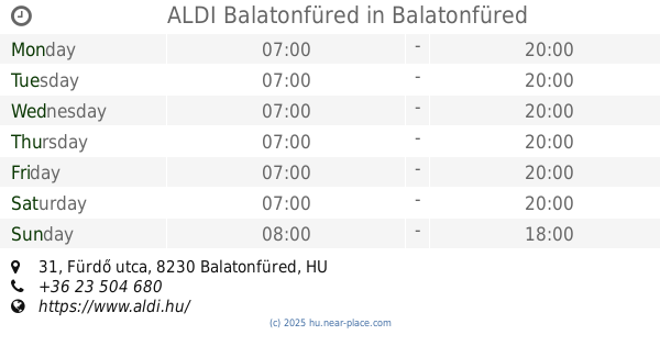
ALDI Balatonfüred
Balatonfüred, Fürdő utca 31
Supermarket
read more
30.176 km
Tesco
Zirc, Állomás utca 5
Supermarket
read more
30.475 km
Tesco Balatonfüred Hipermarket
Balatonfüred, Széchenyi István utca 55
Supermarket
read more
30.475 km
TESCO
Balatonfüred, Széchenyi István utca 55
Supermarket
read more
30.483 km
SPAR market
Balatonfüred, Széchenyi István utca 47
Supermarket
read more
📑
all categories
Accounting
Administrative area level 1
Administrative area level 2
Airport
Amusement park
Aquarium
Art gallery
Atm
Bakery
Bank
Bar
Beauty salon
Bicycle store
Book store
Bowling alley
Bus station
Cafe
Campground
Car dealer
Car rental
Car repair
Car wash
Casino
Cemetery
Church
City hall
Clothing store
Colloquial area
Convenience store
Country
Courthouse
Dentist
Department store
Doctor
Electrician
Electronics store
Embassy
Finance
Fire station
Florist
Food
Funeral home
Furniture store
Gas station
General contractor
Grocery or supermarket
Gym
Hair care
Hardware store
Health
Hindu Temple
Home goods store
Hospital
Insurance agency
Intersection
Jewelry store
Laundry
Lawyer
Library
Light rail station
Liquor store
Local government office
Locality
Locksmith
Lodging
Meal delivery
Meal takeaway
Mosque
Movie rental
Movie theater
Moving company
Museum
Natural feature
Neighborhood
Night club
Painter
Park
Parking
Pet store
Pharmacy
Physiotherapist
Place of worship
Plumber
Point of interest
Police
Political
Post office
Premise
Real estate agency
Restaurant
Roofing contractor
Route
Rv park, camping
School
Shoe store
Shopping mall
Spa
Stadium
Storage
Store
Subpremise
Subway station
Supermarket
Synagogue
Taxi stand
Train station
Transit station
Travel agency
University
Veterinary care
Zoo
administrative area level 3
sublocality level 1
↑