Supermarket nearby Penny Market
Hungary
Supermarket nearby Penny Market
Penny Market
Jászárokszállás, Kossuth Lajos utca 4 Ungarn
contacts phone
:
+36
Latitude:
47.644382
, Longitude:
19.9784793
read more
nearest Supermarket
26 m
Coop szuper
Jászárokszállás, Kossuth Lajos utca 1
Supermarket
read more
26 m
Maxi-Coop Üzlet
Jászárokszállás, Kossuth Lajos utca 1
Supermarket
read more
14.733 km
TESCO
Gyöngyös, Vásár utca 2
Supermarket
read more
14.986 km
Penny Market
Gyöngyös, Gyöngyvirág utca 2
Supermarket
read more
15.132 km
Lidl
Gyöngyös
Supermarket
read more
15.222 km
Aga-Vas Kft.
Gyöngyös, Gyártelep utca, 1.
Supermarket
read more
15.468 km
SPAR Szupermarket
Gyöngyös, Jókai Mór utca 57
Supermarket
read more
15.864 km
Coop Mini
Jászberény, Gyöngyösi út 54
Supermarket
read more
16.011 km
Coop
Gyöngyös, Fő tér
Supermarket
read more
16.743 km
Coop szuper
Jászberény, Szabadság tér 4
Supermarket
read more
16.743 km
COOP Star szupermarket
Jászberény, Szabadság tér 4
Supermarket
read more
18.235 km
TESCO
Jászberény, Nagykátai út 2/A
Supermarket
read more
18.261 km
Nemzeti Dohánybolt
Jászberény, Nagykátai út 3
Supermarket
read more
18.297 km
Penny Market
Jászberény, Nagykátai u. 4.
Supermarket
read more
18.383 km
Lidl
Jászberény, Nagykátai út 7/A
Supermarket
read more
18.684 km
Aldi
Jászberény, Nagykátai út 22
Supermarket
read more
21.883 km
SPAR Szupermarket
Hatvan, Nádasdy Tamás utca 2
Supermarket
read more
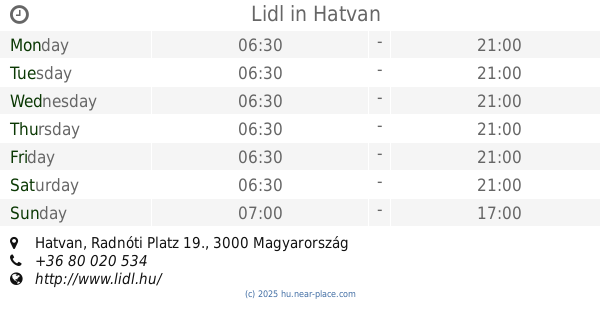
23.003 km
Lidl
Hatvan, Radnóti Platz 19.
Supermarket
read more
23.675 km
TESCO Hipermarket
Hatvan, Bibó István út 1
Supermarket
read more
23.735 km
Aldi
Hatvan, Bibó István utca 3
Supermarket
read more
23.736 km
Tesco
Hatvan, Bibó István út 1
Supermarket
read more
23.847 km
Penny Market
Heves, Szerelem Alfréd u. 7-9.
Supermarket
read more
24.874 km
Coop Üzlet - Élelmiszer
Lőrinci, 15,, Szabadság tér 14
Supermarket
read more
24.944 km
Coop
Alattyán, Szent István út 2-4
Supermarket
read more
27.78 km
Tóalmási Húsüzlet-pecsenyes
Tóalmás, Rákóczi Ferenc út
Supermarket
read more
📑
all categories
Accounting
Administrative area level 1
Administrative area level 2
Airport
Amusement park
Aquarium
Art gallery
Atm
Bakery
Bank
Bar
Beauty salon
Bicycle store
Book store
Bowling alley
Bus station
Cafe
Campground
Car dealer
Car rental
Car repair
Car wash
Casino
Cemetery
Church
City hall
Clothing store
Colloquial area
Convenience store
Country
Courthouse
Dentist
Department store
Doctor
Electrician
Electronics store
Embassy
Finance
Fire station
Florist
Food
Funeral home
Furniture store
Gas station
General contractor
Grocery or supermarket
Gym
Hair care
Hardware store
Health
Hindu Temple
Home goods store
Hospital
Insurance agency
Intersection
Jewelry store
Laundry
Lawyer
Library
Light rail station
Liquor store
Local government office
Locality
Locksmith
Lodging
Meal delivery
Meal takeaway
Mosque
Movie rental
Movie theater
Moving company
Museum
Natural feature
Neighborhood
Night club
Painter
Park
Parking
Pet store
Pharmacy
Physiotherapist
Place of worship
Plumber
Point of interest
Police
Political
Post office
Premise
Real estate agency
Restaurant
Roofing contractor
Route
Rv park, camping
School
Shoe store
Shopping mall
Spa
Stadium
Storage
Store
Subpremise
Subway station
Supermarket
Synagogue
Taxi stand
Train station
Transit station
Travel agency
University
Veterinary care
Zoo
administrative area level 3
sublocality level 1
↑