Supermarket nearby Penny Market
Hungary
Supermarket nearby Penny Market
Penny Market
Cegléd, Malomtó szél 27 Magyarország
contacts phone
:
+36
Latitude:
47.1827409
, Longitude:
19.7991419
read more
nearest Supermarket
30 m
Parkoló
Cegléd, Unnamed Road
Supermarket
read more
278 m
TESCO
Cegléd, Malomtó szél 30
Supermarket
read more
374 m
Pumukli Üzletház Cegléd
Cegléd, Reggel utca 2
Supermarket
read more
775 m
SPAR Szupermarket
Cegléd, Kossuth Ferenc utca 29
Supermarket
read more
1.233 km
Kézműves ABC
Cegléd, Kossuth Ferenc utca 3
Supermarket
read more
1.382 km
SPAR Market
Cegléd, 9-10, Kossuth tér
Supermarket
read more
1.382 km
SPAR
Cegléd, 9-10, Kossuth tér
Supermarket
read more
1.692 km
Lidl
Cegléd
Supermarket
read more
1.886 km
ALDI Cegléd
Cegléd, Pesti út 93
Supermarket
read more
2.129 km
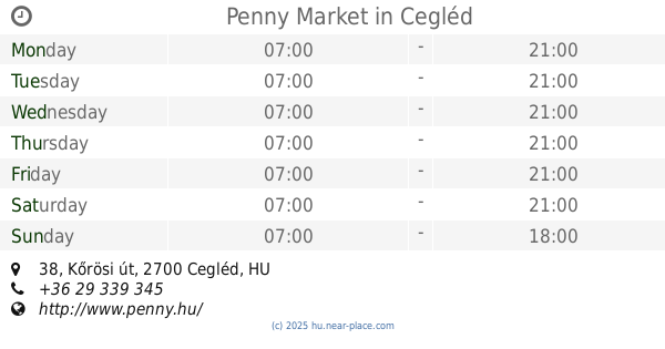
Penny Market
Cegléd, Kőrösi út 38
Supermarket
read more
15.734 km
TESCO
Albertirsa, Vasút utca 4/13
Supermarket
read more
16.02 km
SPAR Szupermarket
Nagykőrös, Ceglédi út 14
Supermarket
read more
16.582 km
Penny Market
Albertirsa, Pesti út 112-118
Supermarket
read more
16.642 km
Penny Market
Albertirsa, Pesti út 112
Supermarket
read more
16.643 km
ALDI
Nagykőrös, Kossuth Lajos út 49-51
Supermarket
read more
17.209 km
Piac
Nagykőrös, Kálvin tér 11
Supermarket
read more
18.085 km
Lidl
Nagykorös, Kecskeméti Straße 73.
Supermarket
read more
18.145 km
Penny Market
Nagykőrös, Kecskeméti u. 86.
Supermarket
read more
18.628 km
Mini Market - Élelmiszer üzlet
Tápiószele, Rákóczi út 42
Supermarket
read more
21.937 km
Privat Max Élelmiszer üzlet
Tápióbicske, Nagykátai út 15
Supermarket
read more
22.221 km
Penny Market
Pilis, Szabadság tér 3.
Supermarket
read more
22.632 km
TESCO
Pilis, Kossuth Lajos út 2/H
Supermarket
read more
22.861 km
TESCO
Pilis, Kossuth Lajos út 2
Supermarket
read more
25.279 km
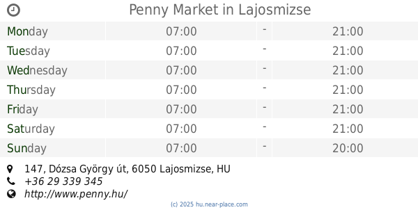
Penny Market
Lajosmizse, Dózsa György út 147
Supermarket
read more
25.518 km
Önért Vegyeskereskedés ABC
Kecskemét, Mályva utca 37
Supermarket
read more
📑
all categories
Accounting
Administrative area level 1
Administrative area level 2
Airport
Amusement park
Aquarium
Art gallery
Atm
Bakery
Bank
Bar
Beauty salon
Bicycle store
Book store
Bowling alley
Bus station
Cafe
Campground
Car dealer
Car rental
Car repair
Car wash
Casino
Cemetery
Church
City hall
Clothing store
Colloquial area
Convenience store
Country
Courthouse
Dentist
Department store
Doctor
Electrician
Electronics store
Embassy
Finance
Fire station
Florist
Food
Funeral home
Furniture store
Gas station
General contractor
Grocery or supermarket
Gym
Hair care
Hardware store
Health
Hindu Temple
Home goods store
Hospital
Insurance agency
Intersection
Jewelry store
Laundry
Lawyer
Library
Light rail station
Liquor store
Local government office
Locality
Locksmith
Lodging
Meal delivery
Meal takeaway
Mosque
Movie rental
Movie theater
Moving company
Museum
Natural feature
Neighborhood
Night club
Painter
Park
Parking
Pet store
Pharmacy
Physiotherapist
Place of worship
Plumber
Point of interest
Police
Political
Post office
Premise
Real estate agency
Restaurant
Roofing contractor
Route
Rv park, camping
School
Shoe store
Shopping mall
Spa
Stadium
Storage
Store
Subpremise
Subway station
Supermarket
Synagogue
Taxi stand
Train station
Transit station
Travel agency
University
Veterinary care
Zoo
administrative area level 3
sublocality level 1
↑