Supermarket nearby Coop
Hungary
Supermarket nearby Coop
Coop
Igal, József Attila utca 3 Magyarország
contacts phone
:
+36
Latitude:
46.5348252
, Longitude:
17.9384955
read more
nearest Supermarket
19.825 km
Szivárvány ABC
Dalmand, Felszabadulás utca 7
Supermarket
read more
21.16 km
Lidl
Kaposvár, Előd vezér utca 3
Supermarket
read more
21.209 km
Lidl
Kaposvár, Füredi utca 97
Supermarket
read more
21.347 km
ALDI
Kaposvár, Árpád utca 31
Supermarket
read more
21.347 km
ALDI Kaposvár
Kaposvár, Árpád utca 31
Supermarket
read more
21.791 km
Penny Market
Kaposvár, Hunyadi János utca 36-46
Supermarket
read more
22.059 km
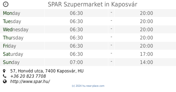
SPAR Szupermarket
Kaposvár, Honvéd utca 57
Supermarket
read more
22.443 km
TESCO
Dombóvár, Köztársaság utca 7
Supermarket
read more
22.686 km
Lidl
Dombóvár, Kórház utca 55
Supermarket
read more
22.691 km
Penny Market
Dombóvár, Teleki utca 19-23
Supermarket
read more
22.693 km
Szuper Diszkont
Kaposvár, Fő utca 29
Supermarket
read more
22.698 km
Lidl
Dombóvár, Kórház utca 120
Supermarket
read more
22.807 km
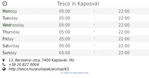
Tesco
Kaposvár, Berzsenyi utca 13
Supermarket
read more
22.807 km
Tesco
Kaposvár, Berzsenyi út 13
Supermarket
read more
22.828 km
SPAR Szupermarket
Dombóvár, Hunyadi tér 23
Supermarket
read more
22.83 km
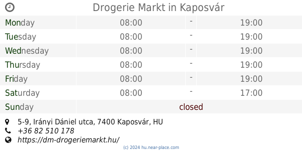
Drogerie Markt
Kaposvár, 7400, Irányi Dániel utca 5-9
Supermarket
read more
23.015 km
SPAR Szupermarket
Kaposvár, Berzsenyi utca 1-3
Supermarket
read more
23.053 km
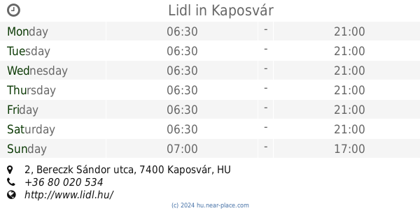
Lidl
Kaposvár, Bereczk Sándor utca 2
Supermarket
read more
23.117 km
Napsugár Áruház
Dombóvár, Hunyadi tér 1
Supermarket
read more
41.152 km
Lidl
Siófok, Zamárdi utca 1-2
Supermarket
read more
42.025 km
SPAR Partner
Siófok, Fő utca 160
Supermarket
read more
45.477 km
SPAR Szupermarket
Komló, Alkotmány utca 45
Supermarket
read more
46.174 km
Tesco Balatonfüred Hipermarket
Balatonfüred, Széchenyi István utca 55
Supermarket
read more
53.338 km
Tesco
Tapolca, Veszprémi út 5
Supermarket
read more
53.345 km
Lidl
Tapolca, Veszprémi Straße 1.
Supermarket
read more
📑
all categories
Accounting
Administrative area level 1
Administrative area level 2
Airport
Amusement park
Aquarium
Art gallery
Atm
Bakery
Bank
Bar
Beauty salon
Bicycle store
Book store
Bowling alley
Bus station
Cafe
Campground
Car dealer
Car rental
Car repair
Car wash
Casino
Cemetery
Church
City hall
Clothing store
Colloquial area
Convenience store
Country
Courthouse
Dentist
Department store
Doctor
Electrician
Electronics store
Embassy
Finance
Fire station
Florist
Food
Funeral home
Furniture store
Gas station
General contractor
Grocery or supermarket
Gym
Hair care
Hardware store
Health
Hindu Temple
Home goods store
Hospital
Insurance agency
Intersection
Jewelry store
Laundry
Lawyer
Library
Light rail station
Liquor store
Local government office
Locality
Locksmith
Lodging
Meal delivery
Meal takeaway
Mosque
Movie rental
Movie theater
Moving company
Museum
Natural feature
Neighborhood
Night club
Painter
Park
Parking
Pet store
Pharmacy
Physiotherapist
Place of worship
Plumber
Point of interest
Police
Political
Post office
Premise
Real estate agency
Restaurant
Roofing contractor
Route
Rv park, camping
School
Shoe store
Shopping mall
Spa
Stadium
Storage
Store
Subpremise
Subway station
Supermarket
Synagogue
Taxi stand
Train station
Transit station
Travel agency
University
Veterinary care
Zoo
administrative area level 3
sublocality level 1
↑