Supermarket nearby Aldi
Hungary
Supermarket nearby Aldi
Aldi
Szeged, Móravárosi körút 3., 6725 Magyarország
contacts phone
:
+36 23 504 680
website:
www.aldi.hu
Latitude:
46.243597
, Longitude:
20.123838
larger map & directions
read more
nearest Supermarket
ALDI Szeged
Szeged, Móravárosi körút 3.
Supermarket
read more
230 m
Lidl
Szeged, Szabadkai út 1/C
Supermarket
read more
231 m
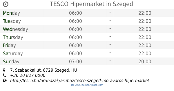
TESCO Hipermarket
Szeged, Szabadkai út 7
Supermarket
read more
453 m
Tesco
Szeged, Szabadkai u 7
Supermarket
read more
1.201 km
Spar
Szeged, Szentháromság utca 68
Supermarket
read more
1.208 km
SPAR Szupermarket
Szeged, Szentháromság utca 68
Supermarket
read more
1.328 km
TUTI Nagyker
Szeged, Kálvária sugárút 87
Supermarket
read more
1.387 km
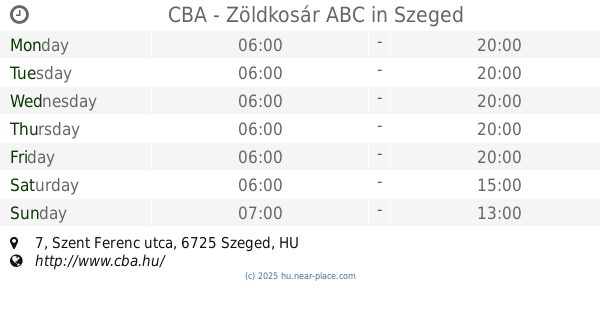
CBA - Zöldkosár ABC
Szeged, Szent Ferenc utca 7
Supermarket
read more
1.634 km
SPAR Szupermarket
Szeged, Londoni körút 3
Supermarket
read more
1.716 km
Tesco
Szeged, Dugonics tér 8-9
Supermarket
read more
1.723 km
TESCO Expressz
Szeged, Dugonics tér 8-9.
Supermarket
read more
1.933 km
SPAR Szupermarket
Szeged, Kölcsey utca 11
Supermarket
read more
2.061 km
SPAR Szupermarket
Szeged, Mars tér 1
Supermarket
read more
2.065 km
616. sz. SPAR
Szeged, Mars tér 1-3
Supermarket
read more
2.095 km
City SPAR
Szeged, Széchenyi tér 15
Supermarket
read more
2.108 km
FNX Diszkont Kft.
Szeged, Vásárhelyi Pál u. 3-5.
Supermarket
read more
2.108 km
FNX Discount Kft.
Szeged, Vásárhelyi Pál u. 3-5.
Supermarket
read more
2.283 km
Tesco
Szeged, Tisza Lajos körút 41
Supermarket
read more
2.59 km
ALDI Szeged
Szeged, Kossuth Lajos sugárút 119
Supermarket
read more
2.692 km
SPAR Szupermarket
Szeged, Csanádi utca 7
Supermarket
read more
2.985 km
Tesco
Szeged, Rókusi körút 42-64
Supermarket
read more
2.985 km
TESCO Extra
Szeged, Rókusi körút 42-64
Supermarket
read more
3.261 km
Penny Market
Szeged, Dorozsmai út 52/A
Supermarket
read more
3.459 km
SPAR Szupermarket
Szeged, Sárosi utca 4
Supermarket
read more
3.804 km
Tesco
Szeged, Makkosházi körút 4
Supermarket
read more
📑
all categories
Accounting
Administrative area level 1
Administrative area level 2
Airport
Amusement park
Aquarium
Art gallery
Atm
Bakery
Bank
Bar
Beauty salon
Bicycle store
Book store
Bowling alley
Bus station
Cafe
Campground
Car dealer
Car rental
Car repair
Car wash
Casino
Cemetery
Church
City hall
Clothing store
Colloquial area
Convenience store
Country
Courthouse
Dentist
Department store
Doctor
Electrician
Electronics store
Embassy
Finance
Fire station
Florist
Food
Funeral home
Furniture store
Gas station
General contractor
Grocery or supermarket
Gym
Hair care
Hardware store
Health
Hindu Temple
Home goods store
Hospital
Insurance agency
Intersection
Jewelry store
Laundry
Lawyer
Library
Light rail station
Liquor store
Local government office
Locality
Locksmith
Lodging
Meal delivery
Meal takeaway
Mosque
Movie rental
Movie theater
Moving company
Museum
Natural feature
Neighborhood
Night club
Painter
Park
Parking
Pet store
Pharmacy
Physiotherapist
Place of worship
Plumber
Point of interest
Police
Political
Post office
Premise
Real estate agency
Restaurant
Roofing contractor
Route
Rv park, camping
School
Shoe store
Shopping mall
Spa
Stadium
Storage
Store
Subpremise
Subway station
Supermarket
Synagogue
Taxi stand
Train station
Transit station
Travel agency
University
Veterinary care
Zoo
administrative area level 3
sublocality level 1
↑