Supermarket nearby Aldi
Hungary
Supermarket nearby Aldi
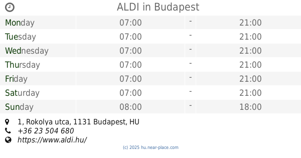
Aldi
12, Petneházy utca, 1139, Budapest, HU Magyarország
contacts phone
:
+36 23 504 680
website:
www.aldi.hu
Latitude:
47.534684
, Longitude:
19.0716246
larger map & directions
read more
nearest Supermarket
334 m
SPAR Szupermarket
Budapest, Váci út 138/A
Supermarket
read more
343 m
SPAR Partner
Budapest, 132b, Váci út
Supermarket
read more
489 m
Family Diszkont
Budapest, Angyalföldi út 38
Supermarket
read more
693 m
SPAR Partner
Budapest, 9, Dunyov István utca
Supermarket
read more
754 m
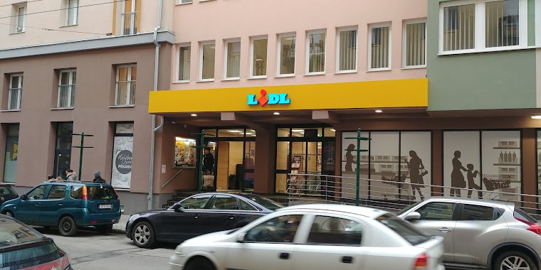
Lidl
Budapest, Béke utca 2
Supermarket
read more
792 m
CBA
Budapest, Dunavirág utca 1
Supermarket
read more
797 m
Tesco
Béke út 13-19 Budapest, XIII. kerület
Supermarket
read more
797 m
TESCO Expressz
Béke út 13-19 Budapest, XIII. kerület
Supermarket
read more
872 m
SPAR Szupermarket
Budapest, Országbíró utca 38-42
Supermarket
read more
941 m
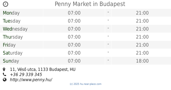
Penny Market
Budapest, Véső utca 11
Supermarket
read more
1.041 km
SPAR Partner
Budapest, Párkány utca 10
Supermarket
read more
1.056 km
SPAR Partner
Budapest, Tomori köz 7
Supermarket
read more
1.133 km
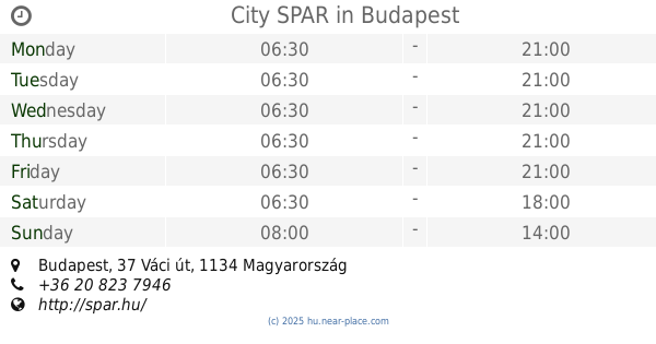
City SPAR
37 Váci út
Supermarket
read more
1.41 km
Gyöngyőce Kicsi Bolt
Budapest, Váci út 70
Supermarket
read more
1.454 km
ALDI
Budapest, Rokolya utca 1
Supermarket
read more
1.564 km
Tesco
Budapest, XIII. kerület, Reitter Ferenc utca 132
Supermarket
read more
1.702 km
SPAR Szupermarket
Budapest, Gyöngyösi sétány 2
Supermarket
read more
1.74 km
SPAR Partner
Budapest, Szent László út 152
Supermarket
read more
1.802 km
Szuperdiszkont
Budapest, Gyöngyösi sétány 10
Supermarket
read more
1.872 km
Penny Market
Budapest, Váci út 9
Supermarket
read more
1.923 km
Penny Market
Budapest, Váci út 50
Supermarket
read more
1.999 km
Aldi
Budapest, Pannónia utca 59-63
Supermarket
read more
2.083 km
Príma
Budapest, Ipoly utca 3
Supermarket
read more
2.138 km
Lidl
Budapest, Victor Hugo utca 11
Supermarket
read more
2.232 km
Cédrus 93 Építőanyag Diszkontáruház
Budapest, Hungária körút 193
Supermarket
read more
📑
all categories
Accounting
Administrative area level 1
Administrative area level 2
Airport
Amusement park
Aquarium
Art gallery
Atm
Bakery
Bank
Bar
Beauty salon
Bicycle store
Book store
Bowling alley
Bus station
Cafe
Campground
Car dealer
Car rental
Car repair
Car wash
Casino
Cemetery
Church
City hall
Clothing store
Colloquial area
Convenience store
Country
Courthouse
Dentist
Department store
Doctor
Electrician
Electronics store
Embassy
Finance
Fire station
Florist
Food
Funeral home
Furniture store
Gas station
General contractor
Grocery or supermarket
Gym
Hair care
Hardware store
Health
Hindu Temple
Home goods store
Hospital
Insurance agency
Intersection
Jewelry store
Laundry
Lawyer
Library
Light rail station
Liquor store
Local government office
Locality
Locksmith
Lodging
Meal delivery
Meal takeaway
Mosque
Movie rental
Movie theater
Moving company
Museum
Natural feature
Neighborhood
Night club
Painter
Park
Parking
Pet store
Pharmacy
Physiotherapist
Place of worship
Plumber
Point of interest
Police
Political
Post office
Premise
Real estate agency
Restaurant
Roofing contractor
Route
Rv park, camping
School
Shoe store
Shopping mall
Spa
Stadium
Storage
Store
Subpremise
Subway station
Supermarket
Synagogue
Taxi stand
Train station
Transit station
Travel agency
University
Veterinary care
Zoo
administrative area level 3
sublocality level 1
↑