Store nearby Szemüvegek Háza Gyula
Hungary
Store nearby Szemüvegek Háza Gyula
Szemüvegek Háza Gyula
Gyula, Bodoky utca 11 Magyarország
contacts phone
:
+36
Latitude:
46.644807
, Longitude:
21.271476
read more
nearest Store
60 m
dm-drogerie markt - Gyula, Béke sugárút
Gyula, Béke sugárút 9-11
Store
read more
65 m
Flóra Ajándék
Gyula, Béke sugárút 7
Store
read more
69 m
Domino GSM
Gyula, Bodoky utca 4
Store
read more
69 m
Hellasz Sport
Gyula, Béke sugárút 5
Store
read more
84 m
Vodafone partner - Csabatel Kft.
Gyula, Hétvezér utca 6
Store
read more
103 m
Dalacsi Húsboltok
Gyula, Béke sugárút 13
Store
read more
122 m
Fagyi Bár
Gyula, Kossuth Lajos tér 2
Store
read more
155 m
Virág-Ajándék
Gyula, Városház utca 1
Store
read more
176 m
Nemzeti dohánybolt
Gyula, 33,, Kossuth Lajos tér 30
Store
read more
183 m
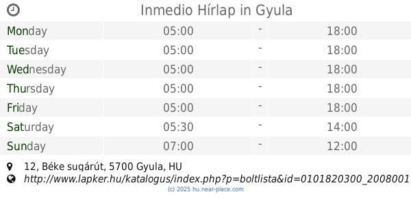
Inmedio Hírlap
Gyula, Béke sugárút 12
Store
read more
195 m
Rossmann Drogéria Parfüméria
Gyula, Kossuth Lajos tér 27
Store
read more
199 m
Update1 üzlet
Gyula, Kossuth Lajos tér 4
Store
read more
218 m
Vár-Játék
Gyula, Városház utca 5
Store
read more
218 m
Maróti Bőrdíszmű
Gyula, Városház utca 5
Store
read more
232 m
Húsbolt
5700 Gyula, Kossuth tér 3
Store
read more
235 m
Sport2000 üzlet
Gyula, Harruckern tér 7
Store
read more
274 m
100 Éves Cukrászda
Gyula, 1, Erkel tér
Store
read more
316 m
ORGOTEL Mobiltelefon Szaküzlet
Gyula, Vásárhelyi Pál utca 8
Store
read more
420 m
Vereshús
Gyula, Honvéd utca 8
Store
read more
447 m
Horgászbolt
Gyula, Megyeház utca 6
Store
read more
609 m
Bediamonds ( háztartási termékek )
Gyula, Ferencesek tere
Store
read more
737 m
Nemzeti Dohánybolt
Gyula, Nürnbergi utca 10
Store
read more
890 m
Gyula Meat Ltd.
Gyula, Béke sugárút 50
Store
read more
948 m
Törökzugi Lottózó
Gyula, Leiningen utca 8
Store
read more
1.041 km
ABC-Áruház
Gyula, Nagyváradi út 2
Store
read more
📑
all categories
Accounting
Administrative area level 1
Administrative area level 2
Airport
Amusement park
Aquarium
Art gallery
Atm
Bakery
Bank
Bar
Beauty salon
Bicycle store
Book store
Bowling alley
Bus station
Cafe
Campground
Car dealer
Car rental
Car repair
Car wash
Casino
Cemetery
Church
City hall
Clothing store
Colloquial area
Convenience store
Country
Courthouse
Dentist
Department store
Doctor
Electrician
Electronics store
Embassy
Finance
Fire station
Florist
Food
Funeral home
Furniture store
Gas station
General contractor
Grocery or supermarket
Gym
Hair care
Hardware store
Health
Hindu Temple
Home goods store
Hospital
Insurance agency
Intersection
Jewelry store
Laundry
Lawyer
Library
Light rail station
Liquor store
Local government office
Locality
Locksmith
Lodging
Meal delivery
Meal takeaway
Mosque
Movie rental
Movie theater
Moving company
Museum
Natural feature
Neighborhood
Night club
Painter
Park
Parking
Pet store
Pharmacy
Physiotherapist
Place of worship
Plumber
Point of interest
Police
Political
Post office
Premise
Real estate agency
Restaurant
Roofing contractor
Route
Rv park, camping
School
Shoe store
Shopping mall
Spa
Stadium
Storage
Store
Subpremise
Subway station
Supermarket
Synagogue
Taxi stand
Train station
Transit station
Travel agency
University
Veterinary care
Zoo
administrative area level 3
sublocality level 1
↑