Store nearby Sarki vegyes
Hungary
Store nearby Sarki vegyes
Sarki vegyes
Csanádapáca, Deák Ferenc utca 1 Magyarország
contacts phone
:
+36
Latitude:
46.5465653
, Longitude:
20.8855772
read more
nearest Store
360 m
Háztartási bolt
Csanádapáca, Batthyány Lajos út 4
Store
read more
395 m
Nemzeti Dohánybolt (18+)
Csanádapáca, Batthyány Lajos út 7
Store
read more
510 m
Midi Market
Csanádapáca, Batthyány Lajos út 38
Store
read more
1.035 km
Öcsi Csemege
Csanádapáca, Zrínyi Miklós utca 1
Store
read more
1.126 km
Csíkós Húsbolt
Csanádapáca, Szent Gellért út 78
Store
read more
1.157 km
Gyöngy Vegyesbolt
Csanádapáca, Damjanich János utca 34
Store
read more
10.574 km
Jégsarok fagyizó
Csorvás, Petőfi utca
Store
read more
11.573 km
CBA
Újkígyós, Kossuth utca 44
Store
read more
11.63 km
Pallér Sándor kistermelő
Újkígyós, Szent István utca 48/a
Store
read more
11.669 km
Benkó Hús Kft.
Újkígyós, Arany János utca 30
Store
read more
11.775 km
Jókai Cukrászda
Újkígyós, Kossuth utca 30-32
Store
read more
11.798 km
Borsos Cukrászda
Medgyesegyháza, Dózsa György utca 19
Store
read more
12.025 km
Nemzeti Dohánybolt
Újkígyós
Store
read more
15.669 km
CBA
Szabadkígyós, József Attila utca
Store
read more
18.445 km
Nemzeti dohánybolt
Kunágota, Rákóczi utca 33
Store
read more
18.883 km
National tobacco shop
Békéscsaba, Győri utca 1
Store
read more
18.975 km
Élelmiszer Vegyesbolt
Békéscsaba, Tompa utca 37
Store
read more
19.148 km
E-merchant Ltd.
Békéscsaba, Szegfű utca 63
Store
read more
19.649 km
Nemzeti Dohánybolt
Békéscsaba, Orosházi utca 35
Store
read more
20.575 km
Decathlon Békéscsaba
Békéscsaba, Szarvasi út 68/2
Store
read more
20.623 km
Team Vidia Kft.
Békéscsaba, Szerdahelyi utca 20
Store
read more
20.623 km
Vidia Team Kft.
Békéscsaba, Szerdahelyi utca 20
Store
read more
20.744 km
Gofri
Békéscsaba
Store
read more
20.776 km
Herbária
Békéscsaba, Szarvasi út 68
Store
read more
20.781 km
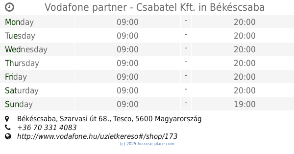
Vodafone partner - Csabatel Kft.
Békéscsaba, Szarvasi út 68., Tesco
Store
read more
📑
all categories
Accounting
Administrative area level 1
Administrative area level 2
Airport
Amusement park
Aquarium
Art gallery
Atm
Bakery
Bank
Bar
Beauty salon
Bicycle store
Book store
Bowling alley
Bus station
Cafe
Campground
Car dealer
Car rental
Car repair
Car wash
Casino
Cemetery
Church
City hall
Clothing store
Colloquial area
Convenience store
Country
Courthouse
Dentist
Department store
Doctor
Electrician
Electronics store
Embassy
Finance
Fire station
Florist
Food
Funeral home
Furniture store
Gas station
General contractor
Grocery or supermarket
Gym
Hair care
Hardware store
Health
Hindu Temple
Home goods store
Hospital
Insurance agency
Intersection
Jewelry store
Laundry
Lawyer
Library
Light rail station
Liquor store
Local government office
Locality
Locksmith
Lodging
Meal delivery
Meal takeaway
Mosque
Movie rental
Movie theater
Moving company
Museum
Natural feature
Neighborhood
Night club
Painter
Park
Parking
Pet store
Pharmacy
Physiotherapist
Place of worship
Plumber
Point of interest
Police
Political
Post office
Premise
Real estate agency
Restaurant
Roofing contractor
Route
Rv park, camping
School
Shoe store
Shopping mall
Spa
Stadium
Storage
Store
Subpremise
Subway station
Supermarket
Synagogue
Taxi stand
Train station
Transit station
Travel agency
University
Veterinary care
Zoo
administrative area level 3
sublocality level 1
↑