Store nearby Ónodi Malom
Hungary
Store nearby Ónodi Malom
Ónodi Malom
Ónod, Rákóczi utca 7 Magyarország
contacts phone
:
+36
Latitude:
47.9954829
, Longitude:
20.921429
read more
nearest Store
2.111 km
Coop
Muhi, Kossuth út 1
Store
read more
4.576 km
Margaréta-Trafik Bt.
Hejőkeresztúr, Petőfi Sándor utca 42
Store
read more
4.636 km
Nemzeti Dohánybolt
Nagycsécs, Kossuth út 11
Store
read more
4.636 km
National tobacco shop
Nagycsécs, Kossuth út 11
Store
read more
4.8 km
Spirnyák Família Bt.
Sajópetri, Szabadság utca 45
Store
read more
5.929 km
Nemzeti Dohánybolt
Bőcs, Rákóczi Ferenc utca 39
Store
read more
12.046 km
Katica cukrászda
Tiszalúc, Gyöngyvirág utca 33
Store
read more
14.232 km
Zöldség-gyümölcs
Miskolc, Petneházy Dávid utca 4
Store
read more
14.643 km
Kevaimpex Kft.
Miskolc, József Attila telep 74
Store
read more
14.923 km
Kádas Frucht Kft.
Miskolc, Melinda utca 3
Store
read more
15.169 km
Nyárfás Kft.
Miskolc, Klapka György utca 15
Store
read more
15.227 km
V & V 93 Kft.
Miskolc, Corvin utca 13
Store
read more
15.243 km
Kék Lagúna Díszállatkereskedés
Miskolc, Bajcsy-Zsilinszky utca 2-4
Store
read more
15.291 km
Inmedio
Miskolc, Király utca
Store
read more
15.301 km
Lottózó
Miskolc, Zsolcai kapu 28
Store
read more
15.32 km
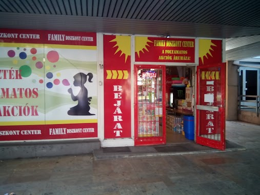
Family Diszkont Center
Miskolc, Corvin utca
Store
read more
15.324 km
Lukasz Art Tattoo
Miskolc, Zsolcai kapu 22
Store
read more
15.381 km
Coop
Miskolc, Hajós Alfréd utca 29
Store
read more
15.427 km
M-Konzol Bt.
Miskolc, Széchenyi István út 78
Store
read more
15.71 km
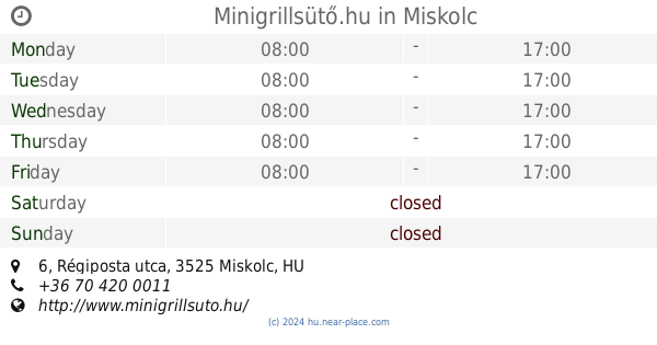
Minigrillsütő.hu
Miskolc, Régiposta utca 6
Store
read more
15.73 km
BioTech USA
Miskolc, Szentpáli utca 2-6
Store
read more
15.78 km
Levendula Kézműves Fagylaltozó
Miskolc, Széchenyi István út 15
Store
read more
15.791 km
Telekom üzlet Miskolc Plaza
Miskolc, Szentpáli utca 2-6
Store
read more
17.167 km
Nemzeti Dohánybolt
Miskolc, Vologda utca
Store
read more
17.869 km
Nessy Divat
Miskolc, Szentpéteri kapu 105
Store
read more
📑
all categories
Accounting
Administrative area level 1
Administrative area level 2
Airport
Amusement park
Aquarium
Art gallery
Atm
Bakery
Bank
Bar
Beauty salon
Bicycle store
Book store
Bowling alley
Bus station
Cafe
Campground
Car dealer
Car rental
Car repair
Car wash
Casino
Cemetery
Church
City hall
Clothing store
Colloquial area
Convenience store
Country
Courthouse
Dentist
Department store
Doctor
Electrician
Electronics store
Embassy
Finance
Fire station
Florist
Food
Funeral home
Furniture store
Gas station
General contractor
Grocery or supermarket
Gym
Hair care
Hardware store
Health
Hindu Temple
Home goods store
Hospital
Insurance agency
Intersection
Jewelry store
Laundry
Lawyer
Library
Light rail station
Liquor store
Local government office
Locality
Locksmith
Lodging
Meal delivery
Meal takeaway
Mosque
Movie rental
Movie theater
Moving company
Museum
Natural feature
Neighborhood
Night club
Painter
Park
Parking
Pet store
Pharmacy
Physiotherapist
Place of worship
Plumber
Point of interest
Police
Political
Post office
Premise
Real estate agency
Restaurant
Roofing contractor
Route
Rv park, camping
School
Shoe store
Shopping mall
Spa
Stadium
Storage
Store
Subpremise
Subway station
Supermarket
Synagogue
Taxi stand
Train station
Transit station
Travel agency
University
Veterinary care
Zoo
administrative area level 3
sublocality level 1
↑