Store nearby Nemzeti Dohánybolt
Hungary
Store nearby Nemzeti Dohánybolt
Nemzeti Dohánybolt
Tököl, Fő utca 36 Ungarn
contacts phone
:
+36
Latitude:
47.327983
, Longitude:
18.965005
read more
nearest Store
624 m
Nemzeti Dohánybolt - Damjanich utca
Százhalombatta, Damjanich utca 14
Store
read more
727 m
Trade Bill Kft.
Tököl, Mester utca 23
Store
read more
891 m
Bagyó Motorszervíz
Tököl, József Attila utca 47
Store
read more
1.319 km
Coop Graho Kft
Tököl, Duna utca 5
Store
read more
1.339 km
Horgász-Vadász Bolt Tóth Lajos
Tököl, Kolozsvári utca 33
Store
read more
1.348 km
Tib-Ink Tattoo
Tököl, Duna utca 5
Store
read more
1.411 km
Ágics Tejbolt
Tököl, Csépi út 32
Store
read more
1.415 km
Milkó Hús Kft
Tököl, Mester utca 94
Store
read more
1.692 km
Nemzeti Dohánybolt
Tököl, Kölcsey Ferenc utca
Store
read more
1.836 km
Companypaintball - Szervezetfejlesztés másképp
Tököl
Store
read more
1.902 km
Csillag ÁBC
Szigethalom, Csillag utca
Store
read more
1.916 km
Nemzeti Dohánybolt
Szigethalom, Sugár utca 27
Store
read more
1.922 km
Nemzeti Dohánybolt
Szigethalom, Iskola út 2
Store
read more
1.944 km
Coop
Szalkszentmárton
Store
read more
1.997 km
Sarokház cukrászda
Szigethalom, Thököly Imre utca 25
Store
read more
2.155 km
Petranella Menyasszonyi Ruhaszalon
Tököl, Huba utca 57/B
Store
read more
2.53 km
DM
Tököl, B. épület, Hermina utca 3
Store
read more
2.636 km
Zoo Land
Tököl
Store
read more
2.642 km
Euro Family
Tököl, Hermina u.1-3
Store
read more
2.743 km
pilotshop.hu
Tököl, Halásztelki 1. kapu
Store
read more
2.783 km
Nemzeti Donànybolt
Szigethalom, József Attila utca
Store
read more
2.892 km
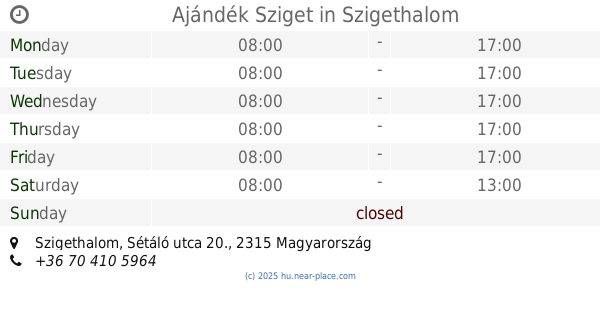
Ajándék Sziget
Szigethalom, Sétáló utca 20.
Store
read more
2.905 km
Tribik Bt Reklámgrafikai és nyomdai szolgáltatások
Százhalombatta, Csenterics Sándor út 3
Store
read more
2.978 km
Orchidea Ház Kertészeti Centrum Kft.
Halásztelek, II. Rákóczi Ferenc út 1
Store
read more
2.983 km
Fedra Tattoo
Szigetszentmiklós, Lordok háza, Apor Vilmos utca 1-3
Store
read more
📑
all categories
Accounting
Administrative area level 1
Administrative area level 2
Airport
Amusement park
Aquarium
Art gallery
Atm
Bakery
Bank
Bar
Beauty salon
Bicycle store
Book store
Bowling alley
Bus station
Cafe
Campground
Car dealer
Car rental
Car repair
Car wash
Casino
Cemetery
Church
City hall
Clothing store
Colloquial area
Convenience store
Country
Courthouse
Dentist
Department store
Doctor
Electrician
Electronics store
Embassy
Finance
Fire station
Florist
Food
Funeral home
Furniture store
Gas station
General contractor
Grocery or supermarket
Gym
Hair care
Hardware store
Health
Hindu Temple
Home goods store
Hospital
Insurance agency
Intersection
Jewelry store
Laundry
Lawyer
Library
Light rail station
Liquor store
Local government office
Locality
Locksmith
Lodging
Meal delivery
Meal takeaway
Mosque
Movie rental
Movie theater
Moving company
Museum
Natural feature
Neighborhood
Night club
Painter
Park
Parking
Pet store
Pharmacy
Physiotherapist
Place of worship
Plumber
Point of interest
Police
Political
Post office
Premise
Real estate agency
Restaurant
Roofing contractor
Route
Rv park, camping
School
Shoe store
Shopping mall
Spa
Stadium
Storage
Store
Subpremise
Subway station
Supermarket
Synagogue
Taxi stand
Train station
Transit station
Travel agency
University
Veterinary care
Zoo
administrative area level 3
sublocality level 1
↑