Store nearby Irgalmas Gyógyszertár Bt.
Hungary
Store nearby Irgalmas Gyógyszertár Bt.
Irgalmas Gyógyszertár Bt.
Budapest, Eötvös út 2 4 Magyarország
contacts phone
:
+36
Latitude:
47.4971884
, Longitude:
18.9895393
read more
nearest Store
45 m
Svábhegyi Patika
Budapest, Eötvös út 4
Store
read more
239 m
stég
Budapest, Villányi út 36
Store
read more
335 m
Jókai Mór szobra
Budapest, Diana utca 4
Store
read more
335 m
Jókai Mór statue
Budapest, Diana utca 4
Store
read more
398 m
Fővárosi Kertészeti Vállalat Szabadsághegyi Telepe
Budapest, Felhő utca 4
Store
read more
458 m
Szechenyi Chillelöde
Budapest, Széchenyi-emlék út 1
Store
read more
478 m
Conte Magyarország Kft.
Budapest, Melinda út 17
Store
read more
1.102 km
TESCO Expressz
Budapest, Pagony utca 27-29
Store
read more
1.144 km
Csokolia cukrászda
Budapest, Szendrő utca 34
Store
read more
1.156 km
Nemzeti Dohánybolt
Budapest, Nógrádi utca
Store
read more
1.36 km
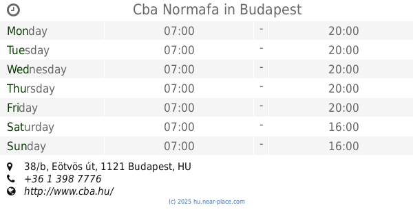
Cba Normafa
Budapest, Eötvös út 38/b
Store
read more
1.452 km
Follione Kft.
Budapest, Istenhegyi út 29
Store
read more
1.766 km
OrtoProfil gyógyászati segédeszköz bolt János Kórház
Budapest
Store
read more
1.775 km
CMM Bt
Budapest, Tusnádi utca 41
Store
read more
1.805 km
Inmedio
Budapest, Apor Vilmos tér 11
Store
read more
1.809 km
Nubu
Budapest, Apor Vilmos tér 11
Store
read more
1.842 km
Szent János Optika
Budapest, Doktor Noszkay Aurél sétány
Store
read more
1.853 km
Kft.
Budapest, Törökbálinti út 2
Store
read more
1.868 km
National tobacco shop
Budapest, Kútvölgyi út 10
Store
read more
1.975 km
Chronos Kft.
Budapest, Apor Vilmos tér 5
Store
read more
1.994 km
Zöldség-gyümölcs
Budapest, 54, Kiss János altábornagy utca
Store
read more
1.998 km
Gina Confectionery
Budapest, Városmajor utca 75
Store
read more
1.999 km
fragola ice cream
Budapest, Kiss János altábornagy utca 54
Store
read more
2.104 km
PLV Hungary Kft
Budapest, Böszörményi út 35b
Store
read more
2.732 km
Chemimark Kft.
Budapest, FSZ. 1., Fillér utca 55
Store
read more
📑
all categories
Accounting
Administrative area level 1
Administrative area level 2
Airport
Amusement park
Aquarium
Art gallery
Atm
Bakery
Bank
Bar
Beauty salon
Bicycle store
Book store
Bowling alley
Bus station
Cafe
Campground
Car dealer
Car rental
Car repair
Car wash
Casino
Cemetery
Church
City hall
Clothing store
Colloquial area
Convenience store
Country
Courthouse
Dentist
Department store
Doctor
Electrician
Electronics store
Embassy
Finance
Fire station
Florist
Food
Funeral home
Furniture store
Gas station
General contractor
Grocery or supermarket
Gym
Hair care
Hardware store
Health
Hindu Temple
Home goods store
Hospital
Insurance agency
Intersection
Jewelry store
Laundry
Lawyer
Library
Light rail station
Liquor store
Local government office
Locality
Locksmith
Lodging
Meal delivery
Meal takeaway
Mosque
Movie rental
Movie theater
Moving company
Museum
Natural feature
Neighborhood
Night club
Painter
Park
Parking
Pet store
Pharmacy
Physiotherapist
Place of worship
Plumber
Point of interest
Police
Political
Post office
Premise
Real estate agency
Restaurant
Roofing contractor
Route
Rv park, camping
School
Shoe store
Shopping mall
Spa
Stadium
Storage
Store
Subpremise
Subway station
Supermarket
Synagogue
Taxi stand
Train station
Transit station
Travel agency
University
Veterinary care
Zoo
administrative area level 3
sublocality level 1
↑