Store nearby Horváth térkő
Hungary
Store nearby Horváth térkő
Horváth térkő
33, Rákos utca, 2119, Pécel, HU Hungary
contacts phone
:
+36 20 543 6212
Latitude:
47.490398
, Longitude:
19.337432
larger map & directions
read more
nearest Store
37 m
Non Stop Baker ABC
Pécel, Rákos utca 26
Store
read more
122 m
AV Group Kft
Pécel, Köztársaság tér 4
Store
read more
122 m
Gazdabolt
Pécel, rét utca 1
Store
read more
142 m
AV Group Hungary Kft
Pécel, rét utca 2
Store
read more
288 m
KISS paints, household and perfume shop
Pécel, Rákos utca 3
Store
read more
307 m
AV Group Kft
Pécel, Rákos utca 2
Store
read more
318 m
Írisz Optika Pécel
Pécel, Rákos utca 2
Store
read more
338 m
Torony Fagyizó
Pécel, Ráday Gedeon tér 6
Store
read more
349 m
Édes Cukrászat
Pécel, Maglódi út 1
Store
read more
444 m
Spájz biobolt
Pécel, Baross utca 5
Store
read more
445 m
Spájz
Pécel, Baross utca
Store
read more
473 m
Játékbolt
Pécel, Baross utca 5/b
Store
read more
474 m
Kreatív Papír - Írószer
Pécel, Baross utca 13
Store
read more
479 m
Kővári húsbolt
Pécel, Baross utca 13
Store
read more
509 m
Dr Ink Tattoo
Pécel, Baross utca 5
Store
read more
551 m
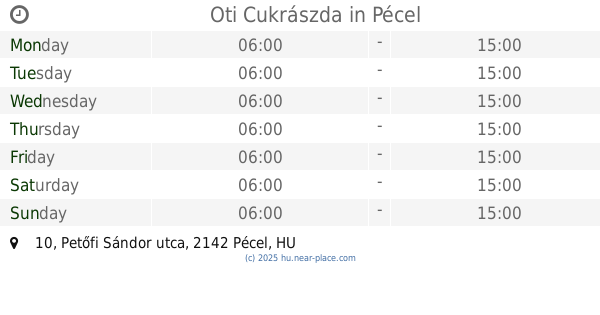
Oti Cukrászda
Pécel, Petőfi Sándor utca 10
Store
read more
615 m
Zephron Kft.
Pécel, Korányi utca 3
Store
read more
777 m
Kosztin Kft
Pécel, Pesti út 38
Store
read more
785 m
Maglódi úti hentes üzlet
Pécel, Maglódi út 14
Store
read more
793 m
1
Pécel, 14, Korányi utca
Store
read more
803 m
Foxi állateledel és horgászbolt
Pécel, Pesti út 63
Store
read more
1.082 km
Nemzeti dohánybolt
Pécel, 35, Tarcsai utca 33
Store
read more
1.29 km
Mandi ABC
Pécel, Fáy Ferenc utca
Store
read more
1.337 km
Pipacs Virágbolt
Pécel, Fáy Ferenc utca
Store
read more
1.57 km
Lots of wood Fatelep
Pécel, Pesti út 120
Store
read more
📑
all categories
Accounting
Administrative area level 1
Administrative area level 2
Airport
Amusement park
Aquarium
Art gallery
Atm
Bakery
Bank
Bar
Beauty salon
Bicycle store
Book store
Bowling alley
Bus station
Cafe
Campground
Car dealer
Car rental
Car repair
Car wash
Casino
Cemetery
Church
City hall
Clothing store
Colloquial area
Convenience store
Country
Courthouse
Dentist
Department store
Doctor
Electrician
Electronics store
Embassy
Finance
Fire station
Florist
Food
Funeral home
Furniture store
Gas station
General contractor
Grocery or supermarket
Gym
Hair care
Hardware store
Health
Hindu Temple
Home goods store
Hospital
Insurance agency
Intersection
Jewelry store
Laundry
Lawyer
Library
Light rail station
Liquor store
Local government office
Locality
Locksmith
Lodging
Meal delivery
Meal takeaway
Mosque
Movie rental
Movie theater
Moving company
Museum
Natural feature
Neighborhood
Night club
Painter
Park
Parking
Pet store
Pharmacy
Physiotherapist
Place of worship
Plumber
Point of interest
Police
Political
Post office
Premise
Real estate agency
Restaurant
Roofing contractor
Route
Rv park, camping
School
Shoe store
Shopping mall
Spa
Stadium
Storage
Store
Subpremise
Subway station
Supermarket
Synagogue
Taxi stand
Train station
Transit station
Travel agency
University
Veterinary care
Zoo
administrative area level 3
sublocality level 1
↑