Store nearby Coop Mini
Hungary
Store nearby Coop Mini
Coop Mini
Budapest, Juharos utca 34 Magyarország
contacts phone
:
+36
Latitude:
47.4087977
, Longitude:
19.0958918
read more
nearest Store
540 m
Állateledelek és Kiegészitök
Csepel-Királyerdő
Store
read more
745 m
King Door 2015 Kft - ablakkészítés, ajtókészítés, ablak,ajtó
Budapest, Határ utca 145
Store
read more
837 m
Tutodekor
Budapest, Aradi vértanúk útja 66
Store
read more
846 m
Adrianus
Budapest, Varjú utca 43
Store
read more
872 m
Gazdabolt
Budapest, Cincér utca 3
Store
read more
905 m
Díszüveges, homokfújás
Budapest, Aradi vértanúk útja 57
Store
read more
906 m
Terrárium készítés HU
Budapest, Aradi vértanúk útja 57
Store
read more
933 m
Lovas cukrászda
Budapest, Szentmiklósi út 103
Store
read more
969 m
Rizmajer Szikvíz
Budapest, Késmárki utca 45
Store
read more
1.033 km
Sarki Közért
Budapest, Fátra utca 5
Store
read more
1.058 km
Fittvital
Budapest, Ordas utca 7
Store
read more
1.181 km
Olcsónyomat
Budapest, Királyerdő út 48
Store
read more
1.233 km
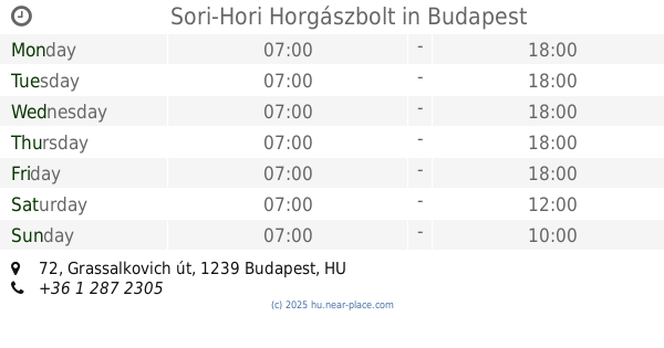
Sori-Hori Horgászbolt
Budapest, Grassalkovich út 72
Store
read more
1.345 km
Mate Tea Webáruház - yerbamate.hu
Budapest, Stefánia utca 12
Store
read more
1.52 km
Demond Optika kft
Budapest, Grassalkovich út 129
Store
read more
1.568 km
Arzenál élelmiszer
Budapest, Szent István út 73
Store
read more
1.685 km
Nemzeti Dohánybolt -Grassi
Budapest, Grassalkovich út 152
Store
read more
1.778 km
S.P.Jagd Vadász-és fegyverbolt, Fegyverműhely
Budapest, 12, Lóállás utca
Store
read more
2.061 km
Nemzeti Dohánybolt
Budapest, Vágóhíd utca
Store
read more
2.215 km
Seriart Nyomdaipari Stúdió
Budapest, Vágóhíd utca 55
Store
read more
2.23 km
Nemzeti Dobánybolt
Budapest, Vörösmarty utca 178
Store
read more
2.26 km
pearl Confectionery
Budapest, Előd utca 38
Store
read more
2.407 km
Brillskin Kozmetika
Budapest, u, Katona József utca 29
Store
read more
2.507 km
Nemzeti Dohánybolt
Csepel-Belváros
Store
read more
2.751 km
dm-drogerie markt
Budapest, Kossuth Lajos utca 89
Store
read more
📑
all categories
Accounting
Administrative area level 1
Administrative area level 2
Airport
Amusement park
Aquarium
Art gallery
Atm
Bakery
Bank
Bar
Beauty salon
Bicycle store
Book store
Bowling alley
Bus station
Cafe
Campground
Car dealer
Car rental
Car repair
Car wash
Casino
Cemetery
Church
City hall
Clothing store
Colloquial area
Convenience store
Country
Courthouse
Dentist
Department store
Doctor
Electrician
Electronics store
Embassy
Finance
Fire station
Florist
Food
Funeral home
Furniture store
Gas station
General contractor
Grocery or supermarket
Gym
Hair care
Hardware store
Health
Hindu Temple
Home goods store
Hospital
Insurance agency
Intersection
Jewelry store
Laundry
Lawyer
Library
Light rail station
Liquor store
Local government office
Locality
Locksmith
Lodging
Meal delivery
Meal takeaway
Mosque
Movie rental
Movie theater
Moving company
Museum
Natural feature
Neighborhood
Night club
Painter
Park
Parking
Pet store
Pharmacy
Physiotherapist
Place of worship
Plumber
Point of interest
Police
Political
Post office
Premise
Real estate agency
Restaurant
Roofing contractor
Route
Rv park, camping
School
Shoe store
Shopping mall
Spa
Stadium
Storage
Store
Subpremise
Subway station
Supermarket
Synagogue
Taxi stand
Train station
Transit station
Travel agency
University
Veterinary care
Zoo
administrative area level 3
sublocality level 1
↑