Store nearby Boróka-Kertészet Kft.
Hungary
Store nearby Boróka-Kertészet Kft.
Boróka-Kertészet Kft.
Hernádkak, Alkotmány utca 12 Magyarország
contacts phone
:
+36
Latitude:
48.0865039
, Longitude:
20.9500384
read more
nearest Store
1.494 km
Nemzeti Dohánybolt
Hernádkak, a, Széchenyi István utca 1
Store
read more
2.18 km
Coop Szuper
Gesztely, Szabadság tér 7
Store
read more
2.18 km
Super Coop
Gesztely, Szabadság tér 7
Store
read more
2.37 km
Goods Market- Hernádnémeti
Hernádnémeti, Kossuth Lajos utca 75
Store
read more
2.961 km
Nemzeti Dohánybolt
Hernádnémeti, Rákóczi Ferenc utca 140
Store
read more
2.994 km
Bagaméri fagyizó
Hernádnémeti, Petőfi Sándor utca 101
Store
read more
4.271 km
World Media Hungary Kft.
Onga, Rákóczi utca 50
Store
read more
4.568 km
Nemzeti Dohánybolt
Onga, Unnamed Road
Store
read more
4.6 km
Nemzeti Dohánybolt
Onga, Rákóczi utca 18
Store
read more
4.683 km
Unio coop
Bőcs, Hősök utca 3
Store
read more
5.082 km
Móra Diszkont
Alsózsolca, Móra Ferenc utca 11
Store
read more
5.113 km
199.számú COOP MINI ABC
Alsózsolca, Tanács út 32
Store
read more
5.228 km
Nemzeti Dohánybolt
Onga, Nádas utca 1
Store
read more
5.265 km
Nemzeti Dohánybolt
Alsózsolca, Kossuth Lajos út 193
Store
read more
5.943 km
Choko Sanel
Sajólád, Ady Endre utca 5
Store
read more
11.492 km
Kádas Frucht Kft.
Miskolc, Melinda utca 3
Store
read more
11.683 km
Lottózó
Miskolc, Zsolcai kapu 28
Store
read more
11.714 km
Lukasz Art Tattoo
Miskolc, Zsolcai kapu 22
Store
read more
11.804 km
Kék Lagúna Díszállatkereskedés
Miskolc, Bajcsy-Zsilinszky utca 2-4
Store
read more
11.85 km
Inmedio
Miskolc, Király utca
Store
read more
12.137 km
Zöldség-gyümölcs
Miskolc, Petneházy Dávid utca 4
Store
read more
12.182 km
V & V 93 Kft.
Miskolc, Corvin utca 13
Store
read more
12.318 km
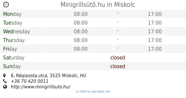
Minigrillsütő.hu
Miskolc, Régiposta utca 6
Store
read more
13.138 km
Nyárfás Kft.
Miskolc, Klapka György utca 15
Store
read more
14.421 km
Nemzeti Dohánybolt
Miskolc, Vologda utca
Store
read more
📑
all categories
Accounting
Administrative area level 1
Administrative area level 2
Airport
Amusement park
Aquarium
Art gallery
Atm
Bakery
Bank
Bar
Beauty salon
Bicycle store
Book store
Bowling alley
Bus station
Cafe
Campground
Car dealer
Car rental
Car repair
Car wash
Casino
Cemetery
Church
City hall
Clothing store
Colloquial area
Convenience store
Country
Courthouse
Dentist
Department store
Doctor
Electrician
Electronics store
Embassy
Finance
Fire station
Florist
Food
Funeral home
Furniture store
Gas station
General contractor
Grocery or supermarket
Gym
Hair care
Hardware store
Health
Hindu Temple
Home goods store
Hospital
Insurance agency
Intersection
Jewelry store
Laundry
Lawyer
Library
Light rail station
Liquor store
Local government office
Locality
Locksmith
Lodging
Meal delivery
Meal takeaway
Mosque
Movie rental
Movie theater
Moving company
Museum
Natural feature
Neighborhood
Night club
Painter
Park
Parking
Pet store
Pharmacy
Physiotherapist
Place of worship
Plumber
Point of interest
Police
Political
Post office
Premise
Real estate agency
Restaurant
Roofing contractor
Route
Rv park, camping
School
Shoe store
Shopping mall
Spa
Stadium
Storage
Store
Subpremise
Subway station
Supermarket
Synagogue
Taxi stand
Train station
Transit station
Travel agency
University
Veterinary care
Zoo
administrative area level 3
sublocality level 1
↑