Spa nearby Fenyves Sports Club
Hungary
Spa nearby Fenyves Sports Club
Fenyves Sports Club
21, Fenyves utca, 8200, Veszprém, HU Hungary
contacts phone
:
+36 30 226 0444
website:
squashveszprem.hu
Latitude:
47.099704
, Longitude:
17.9089021
larger map & directions
read more
nearest Spa
Fenyves Sport Club
Veszprém, Fenyves utca 21
Spa
read more
1.58 km
Aura Hidromasszázs Stúdió
Veszprém, 8200, Török Ignác utca 4
Spa
read more
10.521 km
Tobruki Strand
Balatonfűzfő, Tobruk utca 1
Spa
read more
11.337 km
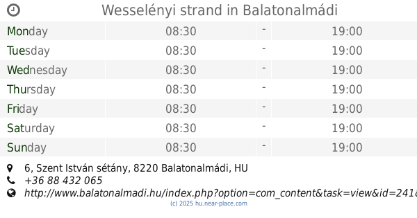
Wesselényi beach
Balatonalmádi, Szent István sétány 6
Spa
read more
11.337 km
Wesselényi beach
Hungary
Spa
read more
11.337 km
Wesselényi strand
Hungary
Spa
read more
11.337 km
Wesselényi strand
Balatonalmádi, Szent István sétány 6
Spa
read more
11.468 km
Balatonalmádi Strand
Balatonalmádi
Spa
read more
11.468 km
Balaton Beach
Balatonalmádi
Spa
read more
11.723 km
MTA üdülő Strand
Balatonalmádi, Neptun utca 5
Spa
read more
11.811 km
Budatava Beach
Balatonalmádi, Lóczy Lajos tér 1
Spa
read more
12.016 km
Zagykazetta Szörf Beach
Balatonfűzfő, Strand
Spa
read more
13.678 km
Laroba Hotel
Alsóörs, Füredi utca 42
Spa
read more
13.835 km
Strand
Alsóörs, Strand sétány
Spa
read more
14.824 km
Strandfürdő
Csopak, Örkény István sétány
Spa
read more
15.362 km
Hotel Szarvaskút**** és Kemencés Étterem
Zirc, Szarvaskút
Spa
read more
15.362 km
Hotel Szarvaskút****
Zirc, Szarvaskút
Spa
read more
16.052 km
Balatonfüred Strand
Balatonfüred, Tagore sétány 3
Spa
read more
18.399 km
Alsóréti szabadstrand
Balatonkenese, Parti sétány 61
Spa
read more
21.482 km
Bercsényi beach
Balatonakarattya
Spa
read more
21.688 km
Sajkodi Strand
Tihany, Sajkodi sor 22
Spa
read more
22.502 km
Gumirádli szabadstrand
Balatonkenese, Aligai utca 99
Spa
read more
23.649 km
Újhelyi Strand
Siófok, Szigliget utca 2
Spa
read more
24.107 km
Galerius Spa and Wellness Center
Siófok, Szent László utca 183
Spa
read more
27.481 km
Piknik Wellness, Konferencia Hotel*** és Étterem
Siófok, Honvéd utca 73
Spa
read more
📑
all categories
Accounting
Administrative area level 1
Administrative area level 2
Airport
Amusement park
Aquarium
Art gallery
Atm
Bakery
Bank
Bar
Beauty salon
Bicycle store
Book store
Bowling alley
Bus station
Cafe
Campground
Car dealer
Car rental
Car repair
Car wash
Casino
Cemetery
Church
City hall
Clothing store
Colloquial area
Convenience store
Country
Courthouse
Dentist
Department store
Doctor
Electrician
Electronics store
Embassy
Finance
Fire station
Florist
Food
Funeral home
Furniture store
Gas station
General contractor
Grocery or supermarket
Gym
Hair care
Hardware store
Health
Hindu Temple
Home goods store
Hospital
Insurance agency
Intersection
Jewelry store
Laundry
Lawyer
Library
Light rail station
Liquor store
Local government office
Locality
Locksmith
Lodging
Meal delivery
Meal takeaway
Mosque
Movie rental
Movie theater
Moving company
Museum
Natural feature
Neighborhood
Night club
Painter
Park
Parking
Pet store
Pharmacy
Physiotherapist
Place of worship
Plumber
Point of interest
Police
Political
Post office
Premise
Real estate agency
Restaurant
Roofing contractor
Route
Rv park, camping
School
Shoe store
Shopping mall
Spa
Stadium
Storage
Store
Subpremise
Subway station
Supermarket
Synagogue
Taxi stand
Train station
Transit station
Travel agency
University
Veterinary care
Zoo
administrative area level 3
sublocality level 1
↑