Restaurant nearby Tesco Döner Kebab
Hungary
Restaurant nearby Tesco Döner Kebab
Tesco Döner Kebab
Budapest, Unnamed Road Węgry
contacts phone
:
+36
Latitude:
47.4779965
, Longitude:
19.1693022
read more
nearest Restaurant
786 m
Kínai Büfé
Budapest, Újhegyi sétány
Restaurant
read more
830 m
Fajt falatok
Budapest, Maglódi út 59
Restaurant
read more
884 m
Don Pepe Pizzéria
Budapest, Újhegyi sétány 16
Restaurant
read more
891 m
Dolorosa Kft - Kegyeleti megemlékezés - Halotti tor -
Budapest, Kozma utca 8-10
Restaurant
read more
1.076 km
Lángosda
Budapest, Újhegyi sétány 14a
Restaurant
read more
1.165 km
Jadran Hamburger és Fagyizó
Budapest
Restaurant
read more
1.169 km
Habibi gyros
Budapest, Bányató utca 16
Restaurant
read more
1.219 km
Büfé
Budapest, Jászberényi út 47
Restaurant
read more
1.246 km
Betyár Pizzéria
Budapest, Sörös utca 6
Restaurant
read more
1.394 km
Margaréta gyorsétterem
Budapest, Tavas utca 1
Restaurant
read more
1.404 km
Széna tér
Budapest, Tavas utca 1
Restaurant
read more
1.607 km
Ezer Sárkány Étterem
Budapest, Jászberényi út 29
Restaurant
read more
1.652 km
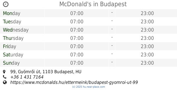
McDonald's
Budapest, Gyömrői út 99
Restaurant
read more
1.675 km
Autó-Ambulancia Kft.
Budapest, Gyömrői út 140
Restaurant
read more
1.85 km
Pizza King Kőbánya
Budapest, Gyömrői út 80
Restaurant
read more
1.865 km
Csősztorony Bisztró
Budapest, Harmat utca 31
Restaurant
read more
1.882 km
Csősztorony
Budapest, Harmat utca 31
Restaurant
read more
2.001 km
Gizmo büfé
Budapest, Jászberényi út 24-36
Restaurant
read more
2.26 km
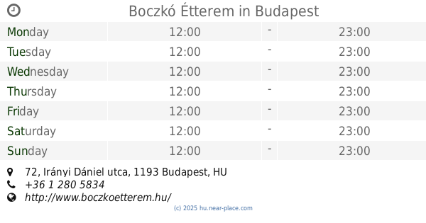
Boczkó Étterem
Budapest, Irányi Dániel utca 72
Restaurant
read more
2.351 km
Szekej Bujdoso
Budapest, Bartók Béla utca 3
Restaurant
read more
2.369 km
freshland
Budapest, Vak Bottyán utca 75
Restaurant
read more
2.379 km
Döner Kebab Express
Budapest, Vak Bottyán utca 75
Restaurant
read more
2.379 km
Pizza Hut - Köki Terminál
Budapest, C, Vak Bottyán utca 75/A
Restaurant
read more
2.389 km
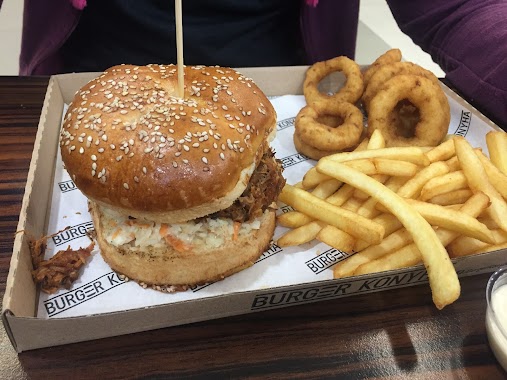
Burger Konyha
Budapest, Kispest köki
Restaurant
read more
2.401 km
Köki Terminál Wok Bar
Budapest
Restaurant
read more
📑
all categories
Accounting
Administrative area level 1
Administrative area level 2
Airport
Amusement park
Aquarium
Art gallery
Atm
Bakery
Bank
Bar
Beauty salon
Bicycle store
Book store
Bowling alley
Bus station
Cafe
Campground
Car dealer
Car rental
Car repair
Car wash
Casino
Cemetery
Church
City hall
Clothing store
Colloquial area
Convenience store
Country
Courthouse
Dentist
Department store
Doctor
Electrician
Electronics store
Embassy
Finance
Fire station
Florist
Food
Funeral home
Furniture store
Gas station
General contractor
Grocery or supermarket
Gym
Hair care
Hardware store
Health
Hindu Temple
Home goods store
Hospital
Insurance agency
Intersection
Jewelry store
Laundry
Lawyer
Library
Light rail station
Liquor store
Local government office
Locality
Locksmith
Lodging
Meal delivery
Meal takeaway
Mosque
Movie rental
Movie theater
Moving company
Museum
Natural feature
Neighborhood
Night club
Painter
Park
Parking
Pet store
Pharmacy
Physiotherapist
Place of worship
Plumber
Point of interest
Police
Political
Post office
Premise
Real estate agency
Restaurant
Roofing contractor
Route
Rv park, camping
School
Shoe store
Shopping mall
Spa
Stadium
Storage
Store
Subpremise
Subway station
Supermarket
Synagogue
Taxi stand
Train station
Transit station
Travel agency
University
Veterinary care
Zoo
administrative area level 3
sublocality level 1
↑