Restaurant nearby Tercia Kópháza
Hungary
Restaurant nearby Tercia Kópháza
Tercia Kópháza
Kópháza, Soproni utca 54 Hungría
contacts phone
:
+36
Latitude:
47.6383934
, Longitude:
16.648308
read more
nearest Restaurant
432 m
Levanda Étterem és Panzió
Kópháza, Fő utca 60
Restaurant
read more
1.57 km
Panoráma Étterem ,Balf
Sopron, Fürdő sor 25
Restaurant
read more
1.769 km
Balfi Halászcsárda
Sopron, Fő utca 2
Restaurant
read more
1.769 km
Fisherman's inn Balf
Sopron, Fő utca 2
Restaurant
read more
1.807 km
Krokodil Étterem, Panzió
Fő utca 8
Restaurant
read more
1.807 km
Krokodil Étterem, Panzió
Sopron, Fő utca 8
Restaurant
read more
1.868 km
nemzeti dohánybolt
Kópháza, 861
Restaurant
read more
3.736 km
Bozi Rozi Pension
9493 Fertőboz, Fő utca 6
Restaurant
read more
4.406 km
Sherry Étterem Kávézó
Sopron, Ipar körút 30
Restaurant
read more
4.415 km
Lángos Büfé
Sopron, Ipar körút 30
Restaurant
read more
4.42 km
Óriás Kebab
Sopron, Ipar körút 30
Restaurant
read more
4.473 km
KFC Sopron
Restaurant
read more
5.031 km
Horgász tanya Harka
Harka
Restaurant
read more
5.236 km
Zolgiz Ételbár
Nagycenk, Soproni utca 1
Restaurant
read more
5.738 km
Bercsényi Borozó és Grillvendéglő
Sopron, Bercsényi Miklós utca 21
Restaurant
read more
6.27 km
Jumbo Burger
Sopron, Bartók Béla utca 2
Restaurant
read more
6.379 km
Fortuna Kávéház és Salátabár
Sopron, Mátyás király utca 34
Restaurant
read more
6.504 km
Kebabking Kft.
Sopron, Torna utca 6
Restaurant
read more
6.505 km
Puskás Restaurant Söröző & Pub
Sopron, 83, Fertődi, Sopron, Várkerület
Restaurant
read more
6.549 km
Söröző a Rókalyukhoz
Sopron, Várkerület 112
Restaurant
read more
6.589 km
Ottimo Burger Kebab Bár
Sopron, Széchenyi tér 20
Restaurant
read more
6.589 km
Ottimo Gourmet Bar
Sopron, Széchenyi tér 20
Restaurant
read more
6.66 km
VanKonyha
Sopron, Deák tér 28
Restaurant
read more
6.675 km
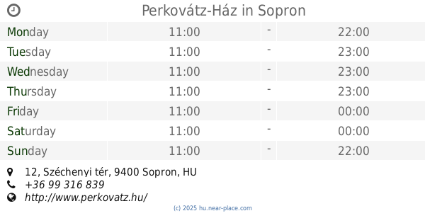
Perkovátz-Ház
Sopron, Széchenyi tér 12
Restaurant
read more
6.693 km
Choco Kebab
Sopron, Unnamed Road
Restaurant
read more
📑
all categories
Accounting
Administrative area level 1
Administrative area level 2
Airport
Amusement park
Aquarium
Art gallery
Atm
Bakery
Bank
Bar
Beauty salon
Bicycle store
Book store
Bowling alley
Bus station
Cafe
Campground
Car dealer
Car rental
Car repair
Car wash
Casino
Cemetery
Church
City hall
Clothing store
Colloquial area
Convenience store
Country
Courthouse
Dentist
Department store
Doctor
Electrician
Electronics store
Embassy
Finance
Fire station
Florist
Food
Funeral home
Furniture store
Gas station
General contractor
Grocery or supermarket
Gym
Hair care
Hardware store
Health
Hindu Temple
Home goods store
Hospital
Insurance agency
Intersection
Jewelry store
Laundry
Lawyer
Library
Light rail station
Liquor store
Local government office
Locality
Locksmith
Lodging
Meal delivery
Meal takeaway
Mosque
Movie rental
Movie theater
Moving company
Museum
Natural feature
Neighborhood
Night club
Painter
Park
Parking
Pet store
Pharmacy
Physiotherapist
Place of worship
Plumber
Point of interest
Police
Political
Post office
Premise
Real estate agency
Restaurant
Roofing contractor
Route
Rv park, camping
School
Shoe store
Shopping mall
Spa
Stadium
Storage
Store
Subpremise
Subway station
Supermarket
Synagogue
Taxi stand
Train station
Transit station
Travel agency
University
Veterinary care
Zoo
administrative area level 3
sublocality level 1
↑