Restaurant nearby Rönkház Étterem
Hungary
Restaurant nearby Rönkház Étterem
Rönkház Étterem
Táti út 489/53 hrsz, 2500, Esztergom, HU Hungary
contacts phone
:
+36 30 508 3648
website:
www.tatito.hu
Latitude:
47.7473099
, Longitude:
18.6779542
larger map & directions
read more
nearest Restaurant
1.289 km
Pecsenyés
Tokod, József Attila utca 91
Restaurant
read more
1.581 km
Horgász Vadász
Tát, Ifjúság út 32
Restaurant
read more
1.774 km
Racing Büfé
Tokodaltáró, Sport utca 1
Restaurant
read more
1.838 km
Viktória Étterem
Tát, Váci Mihály utca 1
Restaurant
read more
2.298 km
Enjoy Gyorsétterem
Tát, Fő út 161-163
Restaurant
read more
2.825 km
Csiffi’s
Tát, Fő út 97
Restaurant
read more
2.856 km
Retro Grill Cafe
Tát, Fekete István utca 2
Restaurant
read more
3.377 km
Öreghalász Hotel
Tát, Fő út 2
Restaurant
read more
3.728 km
Pizzeria Pizza Pala
Esztergom, Damjanich utca 113
Restaurant
read more
4.253 km
Hadzsi falodája
Dorog, Bányász körönd 5
Restaurant
read more
4.828 km
Dudó Bohóc Büfé
Dorog, Hungary, Esztergomi út 3
Restaurant
read more
5.077 km
Shellni kínai gyorsbüfé
Dorog, Hősök tere 19
Restaurant
read more
5.358 km
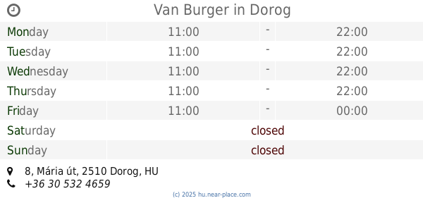
Van Burger
Dorog, Mária út 8
Restaurant
read more
5.372 km
Jenny's
Dorog, Mária út 18
Restaurant
read more
5.374 km
Dénes Lángossütője
Dorog, Mária út 25
Restaurant
read more
5.479 km
Matyi lángos
Dorog, Pataksor-Alsó utca 1
Restaurant
read more
5.52 km
Kapos
Dorog, Munkás út 1
Restaurant
read more
5.57 km
Elvis gyorsétterem
Dorog, 21, Munkás utca
Restaurant
read more
6.033 km
Vezér büfé
Esztergom, Baross Gábor út 4
Restaurant
read more
6.099 km
Border Tavern
Dorog, Bécsi út 1
Restaurant
read more
6.103 km
Baross Bisztró
Esztergom, Baross Gábor út 32
Restaurant
read more
6.108 km
Porto Kávézó és Delikát
Esztergom, Kiss János altábornagy utca 9
Restaurant
read more
6.43 km
Szalma Panzió
Esztergom, Nagy Duna sétány 2.
Restaurant
read more
6.748 km
Söröző
Esztergom, Simor János utca 70
Restaurant
read more
6.889 km
Burger Box
Esztergom, Simor János utca 38
Restaurant
read more
📑
all categories
Accounting
Administrative area level 1
Administrative area level 2
Airport
Amusement park
Aquarium
Art gallery
Atm
Bakery
Bank
Bar
Beauty salon
Bicycle store
Book store
Bowling alley
Bus station
Cafe
Campground
Car dealer
Car rental
Car repair
Car wash
Casino
Cemetery
Church
City hall
Clothing store
Colloquial area
Convenience store
Country
Courthouse
Dentist
Department store
Doctor
Electrician
Electronics store
Embassy
Finance
Fire station
Florist
Food
Funeral home
Furniture store
Gas station
General contractor
Grocery or supermarket
Gym
Hair care
Hardware store
Health
Hindu Temple
Home goods store
Hospital
Insurance agency
Intersection
Jewelry store
Laundry
Lawyer
Library
Light rail station
Liquor store
Local government office
Locality
Locksmith
Lodging
Meal delivery
Meal takeaway
Mosque
Movie rental
Movie theater
Moving company
Museum
Natural feature
Neighborhood
Night club
Painter
Park
Parking
Pet store
Pharmacy
Physiotherapist
Place of worship
Plumber
Point of interest
Police
Political
Post office
Premise
Real estate agency
Restaurant
Roofing contractor
Route
Rv park, camping
School
Shoe store
Shopping mall
Spa
Stadium
Storage
Store
Subpremise
Subway station
Supermarket
Synagogue
Taxi stand
Train station
Transit station
Travel agency
University
Veterinary care
Zoo
administrative area level 3
sublocality level 1
↑