Restaurant nearby Makk 7 Söröző
Hungary
Restaurant nearby Makk 7 Söröző
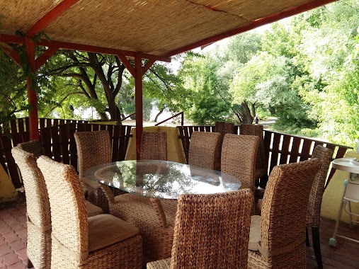
Makk 7 Söröző
16, Deák Ferenc utca, 2132, Göd, HU Hungary
contacts phone
:
+36 27 332 955
Latitude:
47.707225
, Longitude:
19.147202
larger map & directions
read more
nearest Restaurant
392 m
Széchenyi A felsőgödi Pizzéria
Göd, Duna út 1/b
Restaurant
read more
852 m
Gyros Bàr
Göd, József utca 43
Restaurant
read more
953 m
Gödi Török Gyros
Göd, Pesti út 167/a
Restaurant
read more
1.123 km
Napsugár Étkezde
Göd, liget utca 2
Restaurant
read more
1.179 km
Ilka Csárda Panzió
Göd, Pesti út 93/a
Restaurant
read more
1.287 km
Naposparty Kft.
Göd, Jósika utca 16
Restaurant
read more
1.312 km
Duna Csárda
Göd, Jósika utca 20
Restaurant
read more
1.318 km
Duna-parti büfé
Göd, Jósika utca 16
Restaurant
read more
1.487 km
Sportterasz
Sződliget, Kakukk utca 33
Restaurant
read more
2.257 km
Lángosos Büfé
Pócsmegyer, Tulipán út 1
Restaurant
read more
2.667 km
Mítosz Vendéglő
Göd, Pesti út 77
Restaurant
read more
2.746 km
Tó Bisztró
Göd, Bartók Béla utca 6
Restaurant
read more
2.749 km
Belga sörház
Göd, Pesti út 72
Restaurant
read more
2.806 km
Üvegház étterem
Sződliget, Duna-part
Restaurant
read more
2.961 km
Gyros Kings
Sződliget, Mátyás király útja 62
Restaurant
read more
3.037 km
Hydra-Terasz
Sződliget, Sződrákos utca 4
Restaurant
read more
3.418 km
Gyümölcsös-Kertvendéglő
Szigetmonostor, Gyümölcsös utca
Restaurant
read more
3.487 km
Széchenyi Csárda
Göd, Béke utca
Restaurant
read more
3.585 km
Kacifánt Terasz
Szigetmonostor, Nagyduna sétány
Restaurant
read more
3.595 km
Kacifánt Terasz
Szigetmonostor, Nagyduna sétány 952/1
Restaurant
read more
4.612 km
Határcsárda
Szentendre, Ady Endre út 43
Restaurant
read more
5.112 km
Páncélos Street Food
Szentendre, Ady Endre út 74
Restaurant
read more
5.639 km
Hasan gyros (új)
Szentendre, Papszigeti út 8
Restaurant
read more
5.645 km
Gyros-sziget
Szentendre, Papszigeti út 1
Restaurant
read more
6.075 km
Los Amigos Pizzéria
Tahitótfalu, Szentendrei út 115
Restaurant
read more
📑
all categories
Accounting
Administrative area level 1
Administrative area level 2
Airport
Amusement park
Aquarium
Art gallery
Atm
Bakery
Bank
Bar
Beauty salon
Bicycle store
Book store
Bowling alley
Bus station
Cafe
Campground
Car dealer
Car rental
Car repair
Car wash
Casino
Cemetery
Church
City hall
Clothing store
Colloquial area
Convenience store
Country
Courthouse
Dentist
Department store
Doctor
Electrician
Electronics store
Embassy
Finance
Fire station
Florist
Food
Funeral home
Furniture store
Gas station
General contractor
Grocery or supermarket
Gym
Hair care
Hardware store
Health
Hindu Temple
Home goods store
Hospital
Insurance agency
Intersection
Jewelry store
Laundry
Lawyer
Library
Light rail station
Liquor store
Local government office
Locality
Locksmith
Lodging
Meal delivery
Meal takeaway
Mosque
Movie rental
Movie theater
Moving company
Museum
Natural feature
Neighborhood
Night club
Painter
Park
Parking
Pet store
Pharmacy
Physiotherapist
Place of worship
Plumber
Point of interest
Police
Political
Post office
Premise
Real estate agency
Restaurant
Roofing contractor
Route
Rv park, camping
School
Shoe store
Shopping mall
Spa
Stadium
Storage
Store
Subpremise
Subway station
Supermarket
Synagogue
Taxi stand
Train station
Transit station
Travel agency
University
Veterinary care
Zoo
administrative area level 3
sublocality level 1
↑