Restaurant nearby Indian Étterem
Hungary
Restaurant nearby Indian Étterem
Indian Étterem
8, Forgách utca, 1139, Budapest, HU Magyarország
contacts phone
:
+36
Latitude:
47.5393144
, Longitude:
19.0723398
larger map & directions
read more
nearest Restaurant
95 m
Laktató Étkezde
Budapest, Lomb utca 34-36.
Restaurant
read more
153 m
Childreno Étterem
Budapest, Váci út 103
Restaurant
read more
156 m
Center Gasztro Kft.
Budapest, Váci út 99
Restaurant
read more
196 m
McDonald's
Budapest, Váci út 95
Restaurant
read more
246 m
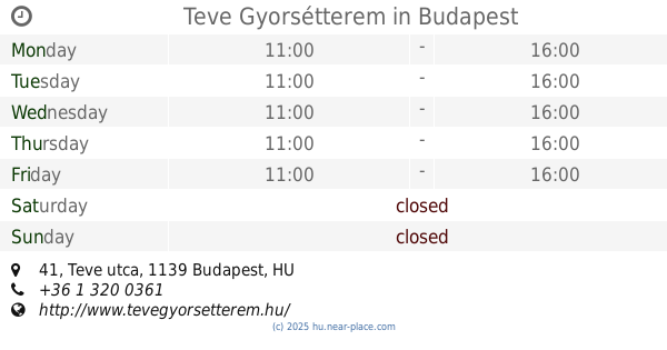
Teve Gyorsétterem
Budapest, 1139, Teve utca 41
Restaurant
read more
408 m
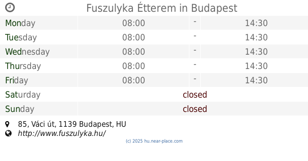
Fuszulyka Étterem
Budapest, Váci út 85
Restaurant
read more
425 m
KEMAL PASA TÖRÖK ÉTTEREM
Budapest, Lomb utca 17
Restaurant
read more
444 m
Kemal Pasa Török Étterem
Budapest, Lomb utca 15
Restaurant
read more
533 m
Burger And Friends
Budapest, Lomb utca 9
Restaurant
read more
533 m
Burger & Friends
Budapest, Lomb utca 9
Restaurant
read more
581 m
Gastro Greens Önkiszolgáló Étterem
Budapest, 1138, Váci út 117
Restaurant
read more
717 m
Miszánkíze Étterem
Budapest, Gömb utca 5
Restaurant
read more
789 m
Food Brothers
Budapest, Csavargyár utca 1
Restaurant
read more
817 m
Erste MelóCafé
Restaurant
read more
819 m
Soup & More Levesbár
Budapest, Teve utca 1d
Restaurant
read more
822 m
Aranypatkó Étkezde
Budapest, Váci út 170c
Restaurant
read more
910 m
香港饭店
Budapest, Béke utca 26
Restaurant
read more
910 m
HONGKONG RESTAURANT
Budapest, Béke utca 26
Restaurant
read more
918 m
Hong Kong Étterem
Budapest, Béke utca 26
Restaurant
read more
960 m
Kínai Étterem
Budapest, Béke utca 23
Restaurant
read more
962 m
Zöld Angyal étterem és Bowling Klubban
Budapest, Országbíró utca 30
Restaurant
read more
1.023 km
Béke Önkiszolgáló Étkezde
Budapest, Béke utca 11
Restaurant
read more
1.074 km
Váci 110 Étterem
Budapest, Váci út 110
Restaurant
read more
1.099 km
827 Speciality Kitchen - Vegán étterem
Budapest, Zsilip utca 4
Restaurant
read more
1.178 km
Napsugár Étkezde..
Budapest, Jász utca
Restaurant
read more
📑
all categories
Accounting
Administrative area level 1
Administrative area level 2
Airport
Amusement park
Aquarium
Art gallery
Atm
Bakery
Bank
Bar
Beauty salon
Bicycle store
Book store
Bowling alley
Bus station
Cafe
Campground
Car dealer
Car rental
Car repair
Car wash
Casino
Cemetery
Church
City hall
Clothing store
Colloquial area
Convenience store
Country
Courthouse
Dentist
Department store
Doctor
Electrician
Electronics store
Embassy
Finance
Fire station
Florist
Food
Funeral home
Furniture store
Gas station
General contractor
Grocery or supermarket
Gym
Hair care
Hardware store
Health
Hindu Temple
Home goods store
Hospital
Insurance agency
Intersection
Jewelry store
Laundry
Lawyer
Library
Light rail station
Liquor store
Local government office
Locality
Locksmith
Lodging
Meal delivery
Meal takeaway
Mosque
Movie rental
Movie theater
Moving company
Museum
Natural feature
Neighborhood
Night club
Painter
Park
Parking
Pet store
Pharmacy
Physiotherapist
Place of worship
Plumber
Point of interest
Police
Political
Post office
Premise
Real estate agency
Restaurant
Roofing contractor
Route
Rv park, camping
School
Shoe store
Shopping mall
Spa
Stadium
Storage
Store
Subpremise
Subway station
Supermarket
Synagogue
Taxi stand
Train station
Transit station
Travel agency
University
Veterinary care
Zoo
administrative area level 3
sublocality level 1
↑