Restaurant nearby Hermina Étterem
Hungary
Restaurant nearby Hermina Étterem
Hermina Étterem
Halásztelek, Kossuth L. u. 1, 2314 Ungarn
contacts phone
:
+36 24 474 129
website:
www.herminaetterem.hu
Latitude:
47.3579411
, Longitude:
18.9851456
larger map & directions
read more
nearest Restaurant
79 m
Pizzicato Snack&Pizza
Halásztelek, II. Rákóczi Ferenc út 40
Restaurant
read more
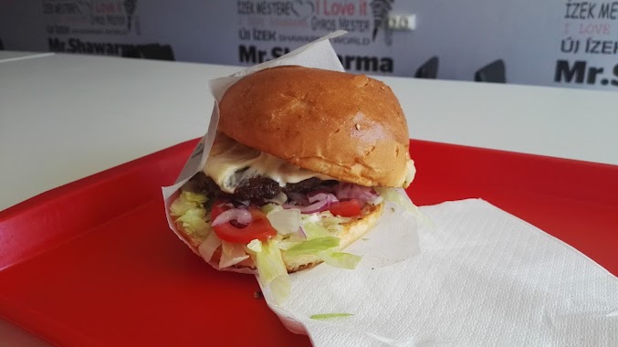
465 m
Gil's Burger
Halásztelek, Somogyi Béla utca 31
Restaurant
read more
486 m
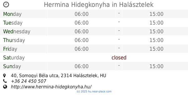
Hermina Hidegkonyha
Halásztelek, Somogyi Béla utca 40
Restaurant
read more
578 m
Hunyadi Büfé
Halásztelek
Restaurant
read more
757 m
CU-IMPEX
Halásztelek
Restaurant
read more
760 m
Sport büfé
Halásztelek, Unnamed Road
Restaurant
read more
772 m
Deniz Török Étterem
Halásztelek, II. Rákóczi Ferenc út 82
Restaurant
read more
815 m
Faloda
Halásztelek, Ady Endre utca 2
Restaurant
read more
1.848 km
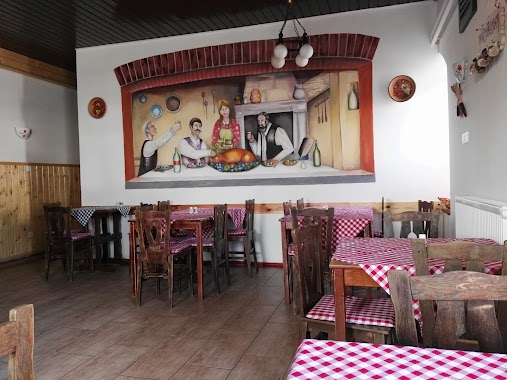
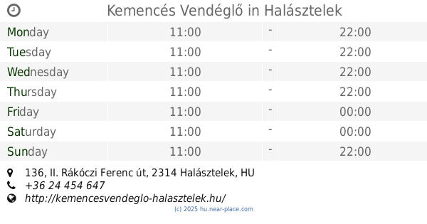
Kemencés Vendéglő
Halásztelek, II. Rákóczi Ferenc út 136
Restaurant
read more
1.87 km
Tuti Étterem
Tököl, Airport Ipari Park
Restaurant
read more
2.768 km
Heaven Pizzéria Tököl
Tököl, Pesti út 1
Restaurant
read more
2.775 km
Dreher Söröző
Tököl, Pesti út
Restaurant
read more
2.782 km
Tibi Atya Pizzázója
Tököl, Pesti út
Restaurant
read more
2.922 km
Bady Hami
Szigetszentmiklós, Gyári út 49
Restaurant
read more
3.028 km
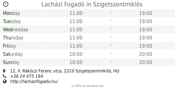
Lacházi Fogadó
Szigetszentmiklós, II. Rákóczi Ferenc utca 12
Restaurant
read more
3.141 km
Fazis Ètelbar
Szigethalom, Mű út
Restaurant
read more
3.147 km
Mr.Shawarma
Szigethalom, Mű út 2
Restaurant
read more
3.151 km
Panda Kínai Étterem
Szigetszentmiklós
Restaurant
read more
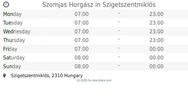
3.497 km
Szomjas Horgász
Szigetszentmiklós
Restaurant
read more
3.727 km
Roadside
Szigetszentmiklós
Restaurant
read more
4.275 km
Kofa Vendéglő
Tököl, Piac tér 9
Restaurant
read more
4.54 km
Faház Sörkert
Szigetszentmiklós, Gyári út 14
Restaurant
read more
5.153 km
Fa-Ló Gyorsétkezde
Érd, Felső utca 50
Restaurant
read more
5.199 km
Horgász Söröző
Szigetszentmiklós
Restaurant
read more
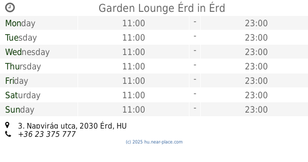
5.434 km
Garden Lounge Érd
Érd, Napvirág utca 3
Restaurant
read more
📑
all categories
Accounting
Administrative area level 1
Administrative area level 2
Airport
Amusement park
Aquarium
Art gallery
Atm
Bakery
Bank
Bar
Beauty salon
Bicycle store
Book store
Bowling alley
Bus station
Cafe
Campground
Car dealer
Car rental
Car repair
Car wash
Casino
Cemetery
Church
City hall
Clothing store
Colloquial area
Convenience store
Country
Courthouse
Dentist
Department store
Doctor
Electrician
Electronics store
Embassy
Finance
Fire station
Florist
Food
Funeral home
Furniture store
Gas station
General contractor
Grocery or supermarket
Gym
Hair care
Hardware store
Health
Hindu Temple
Home goods store
Hospital
Insurance agency
Intersection
Jewelry store
Laundry
Lawyer
Library
Light rail station
Liquor store
Local government office
Locality
Locksmith
Lodging
Meal delivery
Meal takeaway
Mosque
Movie rental
Movie theater
Moving company
Museum
Natural feature
Neighborhood
Night club
Painter
Park
Parking
Pet store
Pharmacy
Physiotherapist
Place of worship
Plumber
Point of interest
Police
Political
Post office
Premise
Real estate agency
Restaurant
Roofing contractor
Route
Rv park, camping
School
Shoe store
Shopping mall
Spa
Stadium
Storage
Store
Subpremise
Subway station
Supermarket
Synagogue
Taxi stand
Train station
Transit station
Travel agency
University
Veterinary care
Zoo
administrative area level 3
sublocality level 1
↑