Restaurant nearby Grill-Café
Hungary
Restaurant nearby Grill-Café
Grill-Café
Albertirsa, 4-es főút, 51-52-es km Magyarország
contacts phone
:
+36
Latitude:
47.261546
, Longitude:
19.596639
read more
nearest Restaurant
8 m
Grill-Café
Gerje
Restaurant
read more
705 m
Aranypatkó Vendéglő
Albertirsa, Pesti út 136
Restaurant
read more
726 m
Buona Sera Pizzéria
Albertirsa, Pesti út 175
Restaurant
read more
1.078 km
Mangó Fagyizó és Pizzéria
Albertirsa, Pesti út 159
Restaurant
read more
2.399 km
Szittyó Vendéglő
Albertirsa, Hősök útja 1
Restaurant
read more
3.78 km
Honey Market Kft.
Albertirsa, Határ utca 53
Restaurant
read more
4.626 km
Manna Büfé
Pilis, Mikes Kelemen utca 1
Restaurant
read more
7.145 km
Fenyves Restaurant
Pilis, 4-es főút
Restaurant
read more
8.98 km
Vasútallomás
Monorierdő, Ország út
Restaurant
read more
11.874 km
Pizza Hut
Pusztavacs, Akácsor 40
Restaurant
read more
12.392 km
Holiday Cafe
Cegléd, Fürdő út 17
Restaurant
read more
13.075 km
Szatymaz Leszvigasz Vendéglő
Dabas
Restaurant
read more
13.075 km
Jozsef Vilmek
Hegyeshalom
Restaurant
read more
13.078 km
Vadász Csárda
Tápióbicske, Rákóczi út 65
Restaurant
read more
13.615 km
Csülök & Csülök
Monor, Ceglédi út 64
Restaurant
read more
14.562 km
Pagoda Pizzéria és Étterem
Kóka, 2243, Dózsa György út 15
Restaurant
read more
15.102 km
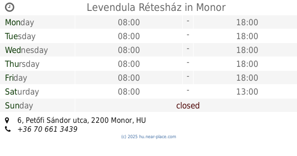
Levendula Rétesház
Monor, Petőfi Sándor utca 6
Restaurant
read more
15.426 km
Nicolette Étterem-Panzió
Monor, Ady Endre utca 38
Restaurant
read more
15.602 km
Tündi mama hamburgerezője
Monor, Vasadi út 1
Restaurant
read more
16.261 km
La Via Étterem
Monor, Ország út 11
Restaurant
read more
16.263 km
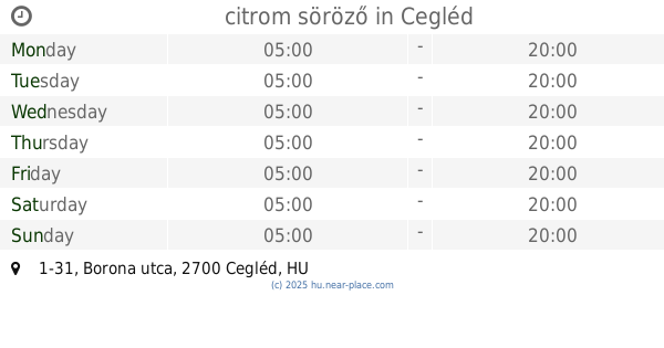
citrom söröző
Cegléd, Borona utca 1-31
Restaurant
read more
16.359 km
Gesztenyés Büfé
Monor, Ország út 19
Restaurant
read more
16.509 km
KétSzabó Pince és Fogadó
Monor, Strázsa hegy, Kadarka sor
Restaurant
read more
17.818 km
Piszkos Fred Étterem
Cegléd, Várkonyi István utca 49
Restaurant
read more
18.018 km
Gerje Vendéglő
Cegléd, Várkonyi István utca 39
Restaurant
read more
📑
all categories
Accounting
Administrative area level 1
Administrative area level 2
Airport
Amusement park
Aquarium
Art gallery
Atm
Bakery
Bank
Bar
Beauty salon
Bicycle store
Book store
Bowling alley
Bus station
Cafe
Campground
Car dealer
Car rental
Car repair
Car wash
Casino
Cemetery
Church
City hall
Clothing store
Colloquial area
Convenience store
Country
Courthouse
Dentist
Department store
Doctor
Electrician
Electronics store
Embassy
Finance
Fire station
Florist
Food
Funeral home
Furniture store
Gas station
General contractor
Grocery or supermarket
Gym
Hair care
Hardware store
Health
Hindu Temple
Home goods store
Hospital
Insurance agency
Intersection
Jewelry store
Laundry
Lawyer
Library
Light rail station
Liquor store
Local government office
Locality
Locksmith
Lodging
Meal delivery
Meal takeaway
Mosque
Movie rental
Movie theater
Moving company
Museum
Natural feature
Neighborhood
Night club
Painter
Park
Parking
Pet store
Pharmacy
Physiotherapist
Place of worship
Plumber
Point of interest
Police
Political
Post office
Premise
Real estate agency
Restaurant
Roofing contractor
Route
Rv park, camping
School
Shoe store
Shopping mall
Spa
Stadium
Storage
Store
Subpremise
Subway station
Supermarket
Synagogue
Taxi stand
Train station
Transit station
Travel agency
University
Veterinary care
Zoo
administrative area level 3
sublocality level 1
↑